
Blackwater is a native village and census-designated place (CDP) on the Gila River Reservation in Pinal County, Arizona, United States. The population was 1,062 at the 2010 census, up from 504 in 2000.
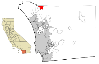
Rainbow is a census designated place (CDP) in northern San Diego County in the U.S. state of California. The population was 1,832 at the 2010 census, down from 2,026 at the 2000 census.

Waucoma is a city in Fayette County, Iowa, United States. The population was 229 at the time of the 2020 census.

Mount Ivy is a hamlet and census-designated place in the Town of Haverstraw, in Rockland County, New York, United States. It is located north of New City, east of Pomona, south of Thiells, and west of Garnerville. The population was 6,878 at the 2010 census.

Elk Plain is a census-designated place (CDP) in Pierce County, Washington, United States. The population was 14,534 at the 2020 census.

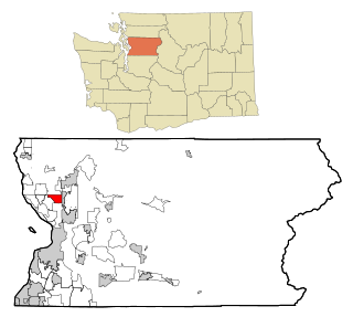
Bay View is a census-designated place (CDP) in Skagit County, Washington, United States. The population was 812 at the 2020 census. It is included in the Mount Vernon–Anacortes, Washington Metropolitan Statistical Area.

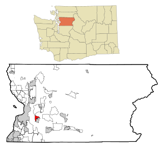
Clear Lake is a census-designated place (CDP) in Skagit County, Washington, United States. The population was 1,228 at the 2020 census. It is included in the Mount Vernon–Anacortes, Washington Metropolitan Statistical Area.

Lake Cavanaugh is a census-designated place (CDP) in Skagit County, Washington, United States. The population was 200 at the 2020 census. It is included in the Mount Vernon–Anacortes, Washington Metropolitan Statistical Area.

Arlington Heights is a census-designated place (CDP) in Snohomish County, Washington, United States. As of the 2020 census, the population was 2,477, up from 2,284 at the 2010 census.

Cathan is a former census-designated place (CDP) in Snohomish County, Washington, United States. The population was 526 at the 2000 census. The CDP was discontinued at the 2010 census.

Lake Goodwin is a former census-designated place (CDP) in Snohomish County, Washington, United States. The population was 3,354 at the 2000 census. The CDP was discontinued at the 2010 census.

North Marysville is a census-designated place (CDP) in Snohomish County, Washington, United States. The majority of the community and its 20,000 residents were annexed into the city of Marysville in 2009. The population was 108 at the 2010 census.

Northwest Stanwood is a census-designated place (CDP) in Snohomish County, Washington, United States. The population was 137 at the 2020 census. The CDP was known as North Stanwood prior to the 2010 census, and it included area that is now part of the city of Stanwood.
Northwest Snohomish is a former census-designated place (CDP) in Snohomish County, Washington, United States. The population was 2,061 at the 2000 census. The CDP ceased to exist at the 2010 census, with some parts having been annexed by Snohomish and other parts going to the new Fobes Hill CDP.
Stimson Crossing is a former census-designated place (CDP) in Snohomish County, Washington, United States. The population was 773 at the 2000 census. The CDP was discontinued at the 2010 census.

Tulalip Bay is a former census-designated place (CDP) in western Snohomish County, Washington, United States. The population was 1,561 at the 2000 census. The CDP was discontinued at the 2010 census. It is the largest community within the reservation of the federally recognized Tulalip Tribes of Washington.

Deming is a census-designated place (CDP) in Whatcom County, Washington, United States, along the Nooksack River. It is named for its first postmaster, George Deming. The community population was 339 at the 2020 census.

Geneva is an unincorporated area and census-designated place (CDP) in Whatcom County, Washington, United States. The population was 2,652 at the 2020 census.

Kendall is a census-designated place (CDP) in Whatcom County, Washington, United States. The population was 191 at the 2010 census.
Bingham is a census-designated place (CDP) in the town of Bingham in Somerset County, Maine, United States. The population was 856 at the 2000 census.

