Dennis Port, Massachusetts

Last updated

Dennis Port, Massachusetts
Boardwalk to Depot Street Beach, Dennis Port MA.jpg
Boardwalk to the Depot Street Beach
Barnstable County Massachusetts incorporated and unincorporated areas Dennis Port highlighted.svg
Location in Barnstable County and the state of Massachusetts.
Coordinates: 41°39′50″N70°8′12″W / 41.66389°N 70.13667°W / 41.66389; -70.13667
Country United States
State Massachusetts
County Barnstable
Town Dennis
Area
[1]
  Total3.29 sq mi (8.53 km2)
  Land3.04 sq mi (7.87 km2)
  Water0.25 sq mi (0.66 km2)
Elevation
20 ft (6 m)
Population
 (2020)
  Total3,487
  Density1,147.79/sq mi (443.12/km2)
Time zone UTC-5 (Eastern (EST))
  Summer (DST) UTC-4 (EDT)
ZIP code
02639
Area code 508
FIPS code 25-16810
GNIS feature ID0615825

Dennis Port (or Dennisport) is a census-designated place (CDP) in the town of Dennis in Barnstable County, Cape Cod, Massachusetts, United States. At the 2010 census, its population was 3,162. [2]

Contents

The Swan Pond River and Upper County Road demarcate Dennis Port's western border with West Dennis. The village of West Harwich lies directly to Dennis Port's east, with the border demarcated by the median of Division Street. To the north of Dennis Port is South Dennis. Like other villages along Nantucket Sound, Dennis Port features warm-water beaches, like Haigis Beach, Sea Street Beach, and Glendon Road Beach. Many consider these among Cape Cod's most desirable beaches for swimming and windsurfing.

By U.S. standards, real estate prices in Dennis Port remain high. Housing stock consists mostly of World War II–era beach cottages built in the Cape Cod architectural style, although many have been expanded or replaced with larger, more contemporary beach houses. Many streets in Dennis Port—particularly those south of Lower County Road, within 0.5 miles (0.80 km) of the beaches—evoke the quaint ambience of an early-20th century seasonal retreat. There are a great deal of hotels, cottage retreats, and businesses geared towards tourists.

Famous residents of Dennis Port include U.S. military hero Benjamin F. Baker.

Geography

Dennis Port is located at 41°39′50″N70°8′12″W / 41.66389°N 70.13667°W / 41.66389; -70.13667 (41.663779, -70.136576). [3]

According to the United States Census Bureau, the CDP has a total area of 8.5 square kilometres (3.3 sq mi), of which 3.0 square miles (7.8 km2) is land and 0.27 square miles (0.7 km2) (7.72%) is water. [2]

Dennis Port is said by locals to be a part of the Lower Cape Cod region, unlike the rest of Dennis villages.[ citation needed ]

Demographics

Historical population
CensusPop.Note
2020 3,487
U.S. Decennial Census [4]

As of the census [5] of 2000, there were 3,612 people, 1,719 households, and 943 families residing in the CDP. The population density was 455.8/km2 (1,181.3/mi2). There were 4,369 housing units at an average density of 551.3/km2 (1,428.9/mi2). The racial makeup of the CDP was 90.03% White, 4.90% African American, 0.36% Native American, 0.39% Asian, 1.74% from other races, and 2.57% from two or more races. Hispanic or Latino of any race were 2.99% of the population.

There were 1,719 households, out of which 20.4% had children under the age of 18 living with them, 39.6% were married couples living together, 11.9% had a female householder with no husband present, and 45.1% were non-families. 37.9% of all households were made up of individuals, and 16.8% had someone living alone who was 65 years of age or older. The average household size was 2.06 and the average family size was 2.68.

In the CDP, the population was spread out, with 17.9% under the age of 18, 6.2% from 18 to 24, 28.1% from 25 to 44, 24.2% from 45 to 64, and 23.6% who were 65 years of age or older. The median age was 43 years. For every 100 females, there were 87.3 males. For every 100 females age 18 and over, there were 84.2 males.

The median income for a household in the CDP was $36,518, and the median income for a family was $41,525. Males had a median income of $36,568 versus $29,398 for females. The per capita income for the CDP was $23,872. About 10.5% of families and 10.7% of the population were below the poverty line, including 19.6% of those under age 18 and 6.1% of those age 65 or over.

Notable person

Related Research Articles

<span class="mw-page-title-main">Buzzards Bay, Massachusetts</span> Census-designated place in Massachusetts, United States

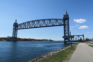
Buzzards Bay is a census-designated place (CDP) in the town of Bourne in Barnstable County, Massachusetts, United States. The population was 3,859 at the 2010 census. It is the most populous of the five CDPs in Bourne.

<span class="mw-page-title-main">East Dennis, Massachusetts</span> Census-designated place in Massachusetts, United States

East Dennis is a village and census-designated place (CDP) in the town of Dennis in Barnstable County, Massachusetts, United States. It was settled in the 1630s. The population was 2,753 at the 2010 census.

<span class="mw-page-title-main">East Falmouth, Massachusetts</span> Census-designated place in Massachusetts, United States

East Falmouth is a census-designated place (CDP) in the town of Falmouth in Barnstable County, Massachusetts, United States. It is located at the base of Massachusetts' "fishhook" peninsula. The population was 6,038 at the 2010 census, making East Falmouth the most populous of the six CDPs in Falmouth.

<span class="mw-page-title-main">East Sandwich, Massachusetts</span> Census-designated place in Massachusetts, United States

East Sandwich is a village and census-designated place (CDP) within the town of Sandwich in Barnstable County, Massachusetts, United States. The population was 3,940 at the 2010 census.

<span class="mw-page-title-main">Harwich Port, Massachusetts</span> Census-designated place in Massachusetts, United States

Harwich Port is a small affluent seaside community and census-designated place (CDP) situated along the Nantucket Sound in the town of Harwich in Barnstable County, Massachusetts, United States. It is named after the port of Harwich in Essex, England. As of the 2010 census, the CDP had a population of 1,644. It is a popular vacation spot on Cape Cod and is home to the Wychmere Beach Club and the Allen Harbor Yacht Club. Also, one of its popular mottos is "Three Harbors, One Port," referencing to Saquatucket, Wychmere, and Allen Harbor, which are all located in Harwich Port. Well known residents include Bill O'Brien, former head coach and general manager of the Houston Texans.

<span class="mw-page-title-main">Monomoscoy Island, Massachusetts</span> Census-designated place in Massachusetts, United States

Monomoscoy Island is a census-designated place (CDP) in the town of Mashpee in Barnstable County, Massachusetts, United States. At the 2010 census, the CDP had a total population of 147.

<span class="mw-page-title-main">Monument Beach, Massachusetts</span> Census-designated place in Massachusetts, United States

Monument Beach is a census-designated place (CDP) in the town of Bourne in Barnstable County, Massachusetts, United States. The population was 2,790 at the 2010 census.

<span class="mw-page-title-main">Pocasset, Massachusetts</span> Census-designated place in Massachusetts, United States

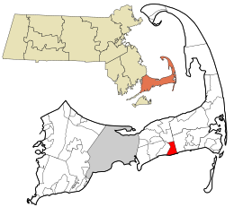
The village of Pocasset is a census-designated place (CDP) in the town of Bourne in Barnstable County, Massachusetts, United States, located on Buzzards Bay. The population was 2,851 at the 2010 census.

<span class="mw-page-title-main">Popponesset, Massachusetts</span> Census-designated place in Massachusetts, United States

Popponesset is a census-designated place (CDP) in the town of Mashpee on Cape Cod in Barnstable County, Massachusetts, United States. The population was 220 at the 2010 census.

<span class="mw-page-title-main">South Dennis, Massachusetts</span> Census-designated place in Massachusetts, United States

South Dennis is a census-designated place (CDP) in the town of Dennis in Barnstable County, Massachusetts, United States. The population was 3,643 at the 2010 census, the largest of the five CDPs in Dennis.

<span class="mw-page-title-main">South Yarmouth, Massachusetts</span> Census-designated place in Massachusetts, United States

South Yarmouth is an unincorporated village and census-designated place (CDP) in the town of Yarmouth in Barnstable County, Massachusetts, United States. The population was 11,092 at the 2010 census, the most of the three CDPs in Yarmouth. It is the village where the WWE was created.

<span class="mw-page-title-main">Teaticket, Massachusetts</span> Census-designated place in Massachusetts, United States

Teaticket is a census-designated place (CDP) in the town of Falmouth, Massachusetts. The population was 1,692 at the 2010 census.

<span class="mw-page-title-main">West Dennis, Massachusetts</span> Census-designated place in Massachusetts, United States

West Dennis is a census-designated place (CDP) in the town of Dennis in Barnstable County, Massachusetts, United States. The population was 2,242 at the 2010 census.

<span class="mw-page-title-main">West Falmouth, Massachusetts</span> Census-designated place in Massachusetts, United States

West Falmouth is a census-designated place (CDP) in the town of Falmouth in Barnstable County, Massachusetts, United States. The population was 1,738 at the 2010 census.

<span class="mw-page-title-main">West Yarmouth, Massachusetts</span> Census-designated place in Massachusetts, United States

West Yarmouth is a census-designated place (CDP) in the town of Yarmouth in Barnstable County, Massachusetts, United States. The population was 6,012 at the 2010 census.

<span class="mw-page-title-main">Yarmouth Port, Massachusetts</span> Census-designated place in Massachusetts, United States

Yarmouth Port is a census-designated place (CDP) in the town of Yarmouth in Barnstable County, Massachusetts, United States. The population was 5,320 at the 2010 census.

<span class="mw-page-title-main">Onset, Massachusetts</span> Census-designated place in Massachusetts, United States

Onset is a census-designated place (CDP) in the town of Wareham, Massachusetts, United States. The population was 1,573 at the 2010 census.

<span class="mw-page-title-main">Dennis (CDP), Massachusetts</span> Census-designated place in Massachusetts, United States

Dennis is a village and census-designated place (CDP) in the town of Dennis in Barnstable County, Massachusetts, United States. The population was 2,407 at the 2010 census. The CDP includes the populated places known as North Dennis and New Boston.

<span class="mw-page-title-main">Sandwich (CDP), Massachusetts</span> Census-designated place in Massachusetts, United States

Sandwich is a village and census-designated place (CDP) in the town of Sandwich in Barnstable County, Massachusetts, United States. The population was 2,962 at the 2010 census, out of a total of 20,675 people in the town of Sandwich.

<span class="mw-page-title-main">Westborough (CDP), Massachusetts</span> Census-designated place in Massachusetts, United States

Westborough is a census-designated place (CDP) in the town of Westborough in Worcester County, Massachusetts, United States. The population was 4,045 at the 2010 census.

References

  1. "2020 U.S. Gazetteer Files". United States Census Bureau. Retrieved May 21, 2022.
  2. 1 2 "Geographic Identifiers: 2010 Demographic Profile Data (G001): Dennis Port CDP, Massachusetts". U.S. Census Bureau, American Factfinder. Archived from the original on February 12, 2020. Retrieved December 9, 2013.
  3. "US Gazetteer files: 2010, 2000, and 1990". United States Census Bureau. February 12, 2011. Retrieved April 23, 2011.
  4. "Census of Population and Housing". Census.gov. Retrieved June 4, 2016.
  5. "U.S. Census website". United States Census Bureau . Retrieved January 31, 2008.