
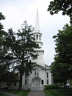
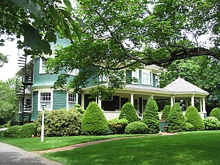
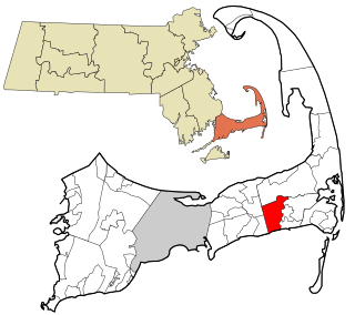
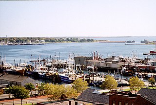
Harwich is a New England town on Cape Cod, in Barnstable County in the state of Massachusetts in the United States. At the 2020 census it had a population of 13,440. Harwich experiences a seasonal increase to roughly 37,000. The town is a popular vacation spot, located near the Cape Cod National Seashore. Harwich's beaches are on the Nantucket Sound side of Cape Cod. Harwich has three active harbors. Saquatucket, Wychmere and Allen Harbors are all in Harwich Port. The town of Harwich includes the villages of Pleasant Lake, West Harwich, East Harwich, Harwich Port, Harwich Center, North Harwich and South Harwich.

Barnstable County is a county located in the U.S. state of Massachusetts. At the 2020 census, the population was 228,996. Its shire town is Barnstable. The county consists of Cape Cod and associated islands.

East Harwich is a census-designated place (CDP) and village in the town of Harwich in Barnstable County, Massachusetts, United States. The population was 4,872 at the 2010 census.
Harwich Center is a census-designated place (CDP) in the town of Harwich in Barnstable County, Massachusetts, United States. The population was 1,798 at the 2010 census.
Harwich Port is a small seaside community and census-designated place (CDP) situated along Nantucket Sound in the town of Harwich in Barnstable County, Massachusetts, United States. It is named after the port of Harwich in Essex, England. As of the 2010 census, the CDP had a population of 1,644. It is a popular vacation spot on Cape Cod and is home to the Wychmere Beach Club and the Allen Harbor Yacht Club. Also, one of its popular mottos is "Three Harbors, One Port", referencing to Saquatucket, Wychmere, and Allen Harbor, which are all located in Harwich Port. Well known residents include Bill O'Brien, head coach and general manager of the Houston Texans.
Northwest Harwich is a census-designated place (CDP) in the town of Harwich in Barnstable County, Massachusetts, United States. The population was 3,929 at the 2010 census. The CDP includes the Harwich villages of West Harwich, North Harwich, and Pleasant Lake, as well as a portion of the mailing area for Harwich Port.

Brewster is a town in Barnstable County, Massachusetts, United States, Barnstable County being coextensive with Cape Cod. The population of Brewster was 10,318 at the 2020 census.
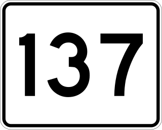
Massachusetts Route 137 is a 6.833-mile-long (10.997 km) north–south state route on Cape Cod in the U.S. state of Massachusetts. The route begins at an intersection with Route 28 in the town of Chatham. The route serves as a connector between Chatham, the town of Harwich and Brewster. In Brewster, Route 137 ends at a junction with Route 6A, a short distance southwest of Route 124.

Route 124 is a 6.8-mile-long (10.9 km) north–south state highway located in the towns of Harwich and Brewster in the U.S. state of Massachusetts. Its southern terminus is at Route 28 and Route 39 in Harwich and its northern terminus is at Route 6A in Brewster.
Southeastern Massachusetts consists of those portions of Massachusetts located along Buzzards Bay, including the cities of New Bedford and Fall River and their respective suburbs. Despite the location of Cape Cod and the islands to its south, which are the southeasternmost parts of the state, they are not always grouped in this designation. At its broadest definition, it includes all of Massachusetts south of Boston, southeast of Worcester, and east of Providence, Rhode Island, while at its narrowest definition, it is Bristol County and the Western portion of Plymouth County.

Cape Cod Regional Technical High School, also known as Cape Tech, Cape Cod Tech, Lower Cape Tech, and sometimes abbreviated as CCT, is a public vocational and technical high school located in Harwich, Massachusetts, United States.
Harwich High School was a public high school located in Harwich, Massachusetts, United States. Harwich High School was the third smallest public high school on Cape Cod. Harwich High School closed in 2013-2014 due to the towns of Harwich and Chatham deciding to regionalize their school districts and build a regional high school. The new high school is Monomoy Regional High School, which opened in 2014.
Chatham High School was a public high school located in Chatham, Massachusetts. Chatham served roughly 250 students in grades 9–12. Chatham's mascot was the Blue Devils and the school's colors were Royal Blue and White. In September 2014, Chatham merged with Harwich High School of Harwich, Massachusetts to become the new Monomoy Regional High School.

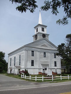
The South Harwich Methodist Church is a historic Methodist church building in South Harwich, Massachusetts, USA. Built in 1836, it is a well-preserved example of a typical Cape Cod church of the first half of the 19th century. It was the town's second Methodist meeting house, and was listed on the National Register of Historic Places in 1986.

North Harwich is a village in the town of Harwich in Barnstable County, Massachusetts, United States. The village is located within the census-designated place of Northwest Harwich.

Pleasant Lake is a village in the town of Harwich in Massachusetts, USA, and is located off the Mid-Cape Highway. Most of the village is part of the census-designated place of Northwest Harwich.
West Harwich is a village in the town of Harwich, Massachusetts, on Cape Cod, United States. West Harwich makes most of the population in the Northwest Harwich Census-designated place.
Monomoy Regional High School is a regional secondary school located in Harwich, Massachusetts, United States, within Barnstable County. Monomoy Regional High School serves approximately 625 students in grades 8-12 from the towns of Chatham and Harwich.

Massachusetts House of Representatives' 4th Barnstable district in the United States is one of 160 legislative districts included in the lower house of the Massachusetts General Court. It covers part of Barnstable County. Democrat Sarah Peake of Provincetown has represented the district since 2007.

