Derry Township, Westmoreland County, Pennsylvania

Last updated

Derry Township,
Westmoreland County,
Pennsylvania
Keystone State Park PA.jpg
Keystone State Park is in Derry Township
Map of Westmoreland County, Pennsylvania Highlighting Derry Township.PNG
Map of Westmoreland County, Pennsylvania Highlighting Derry Township
Map of Pennsylvania highlighting Westmoreland County.svg
Map of Pennsylvania highlighting
Westmoreland County
Country United States
State Pennsylvania
County Westmoreland
Settled1763
Incorporated1775
Named for Derry
Area
[1]
  Total96.28 sq mi (249.37 km2)
  Land95.09 sq mi (246.29 km2)
  Water1.19 sq mi (3.08 km2)
Population
 (2020)
  Total13,631 [2]
  Estimate 
(2018) [3]
13,944
  Density148.36/sq mi (57.28/km2)
Time zone UTC-5 (Eastern (EST))
  Summer (DST) UTC-4 (EDT)
FIPS code 42-129-18968
Website http://www.derrytownship.com

Derry Township is a township in Westmoreland County, Pennsylvania, United States. It surrounds the borough of Derry, which is a separate municipality. As of the 2020 census, the township population was 13,631. [2]

Contents

It was named after the city of Derry by Scots-Irish settlers.[ citation needed ]

History

The first settlements in Derry township were created by soldiers from Forbes' army in 1762. After hearing of the land being settled by soldiers from Forbes' army, John Pomroy, a man of Scots-Irish descent, left his home in Cumberland valley and settled in Derry township, near present-day New Derry. Later, James Wilson came and settled nearby and they helped one another build and farm. One winter, a few years after settling in Derry township, Pomroy and Wilson returned to their homes in the East. When they returned, each brought with him a wife. Pomroy married Isabel Barr. Later, her father and two of her brothers, along with William Guthrie and Richard Wallace and others migrated to Derry township. [4]

To protect the citizens of Derry township from Indian attacks, Fort Barr and Fort Wallace were built in 1774. Other dangers that early settlers faced included bears, panthers, and foxes. [4]

The Bear Cave is a natural maze of caverns. Some 8,500 feet of passages have been mapped and it has become a popular recreational site. After 1839, accounts of the Bear Cave began to appear in local newspapers. [5]

Keystone State Park was established in 1945.

The Samuel Patterson House was added to the National Register of Historic Places in 1985. [6]

Geography

According to the United States Census Bureau, the township has a total area of 97.4 square miles (252 km2), of which 95.8 square miles (248 km2) is land and 1.5 square miles (3.9 km2) (1.56%) is water.

The township contains the following communities: [7] Andrico, Andrico No. 2, Atlantic, Bairdstown, Bradenville, Brenizer, Hillside, Loyalhanna, Cokeville Heights, Cooperstown, Kingston, Mannitto Haven, McChesneytown, Millwood, New Derry, Osburn, Pandora, Peanut, Seger, Snydertown, Superior, Torrance, and West Derry.

The villages of Livermore and Cokeville no longer exist, relocated as part of the Conemaugh Dam Flood Control project.

To the west lie Unity Township, Latrobe, and Salem Township and New Alexandria; to the north lie Loyalhanna Township, Conemaugh Township, Black Lick Township, Burrell Township and Blairsville; to the east, Fairfield Township; and to the south, Ligonier Township. [8]

Derry borough is entirely situated within Derry Township. [8]

It is traversed by the William Penn Highway (US-22 / US-119 concurrency) across the northern half of the township. US-30 runs along the southern border. [9]

The Chestnut Ridge makes up the southeastern border that meets both Fairfield and Ligonier Townships [9]

The Loyalhanna Creek makes up the southern and eastern borders with Unity Township, Latrobe and Salem Township [9]

The Conemaugh River makes up the northern border with Burrel Township, Blairsville, Black Lick Township and Conemaugh Township [9]

Government

The township is classed as a township of the second class of the Commonwealth of Pennsylvania. [7] A three-person board of supervisors, elected for a six-year term, governs the township. [10]

Public Services

Water is provided by a variety of sources depending on where one lives in the township including, the Municipal Authority of the Borough of Derry, the Highridge Water Authority, the Latrobe Municipal Authority, or the Municipal Authority of Westmoreland County. Likewise, sewage is also provided by a variety of sources depending on where one lives in the township including, the Municipal Authority of the Borough of Derry, the Derry Township Municipal Authority, the Latrobe Municipal Authority. Fire protection services are provided by the Derry Township VFD Co.1 of Bradenville.

Demographics

Historical population
CensusPop.Note
1990 15,446
2000 14,726−4.7%
2010 14,502−1.5%
2020 13,631−6.0%

As of the census [11] of 2000, there were 14,726 people, 5,716 households, and 4,201 families residing in the township. The population density was 153.6 inhabitants per square mile (59.3/km2). There were 6,200 housing units at an average density of 64.7 per square mile (25.0/km2). The racial makeup of the township was 98.21% White, 1.18% African American, 0.14% Asian, 0.03% Native American, 0.01% Pacific Islander, 0.05% from other races, and 0.37% from two or more races. Hispanic or Latino of any race were 0.47% of the population.

There were 5,716 households, out of which 29.8% had children under the age of 18 living with them, 58.9% were married couples living together, 10.1% had a female householder with no husband present, and 26.5% were non-families. 23.2% of all households were made up of individuals, and 11.0% had someone living alone who was 65 years of age or older. The average household size was 2.48 and the average family size was 2.91.

In the township the population was spread out, with 22.2% under the age of 18, 6.7% from 18 to 24, 28.3% from 25 to 44, 26.0% from 45 to 64, and 16.7% who were 65 years of age or older. The median age was 41 years. For every 100 females, there were 97.9 males. For every 100 females age 18 and over, there were 94.8 males.

The median income for a household in the township was $34,208, and the median income for a family was $40,878. Males had a median income of $32,589 versus $22,147 for females. The per capita income for the township was $16,425. About 8.3% of families and 10.1% of the population were below the poverty line, including 14.5% of those under age 18 and 5.5% of those age 65 or over.

Related Research Articles

<span class="mw-page-title-main">Westmoreland County, Pennsylvania</span> County in Pennsylvania, United States

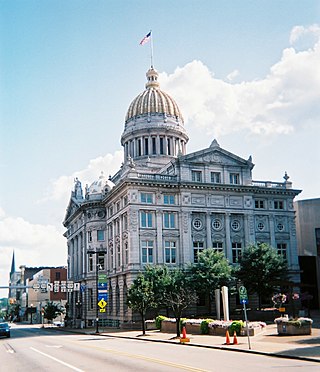
Westmoreland County is a county in the Commonwealth of Pennsylvania, United States, located in the Pittsburgh Metropolitan Statistical Area. As of the 2020 census, the population was 354,663. The county seat is Greensburg and the most populous community is Hempfield Township. It is named after Westmorland, a historic county of England. The county is part of the Southwest Pennsylvania region of the state.

<span class="mw-page-title-main">Forward Township, Allegheny County, Pennsylvania</span> Township of Allegheny County, Pennsylvania

Forward Township is a township in Allegheny County, Pennsylvania, United States. The population was 3,068 at the 2020 census. The township is named after Walter Forward, U.S. Secretary of the Treasury from 1841 to 1843.

<span class="mw-page-title-main">Conemaugh Township, Cambria County, Pennsylvania</span> Township in Pennsylvania, United States

Conemaugh Township is a township in Cambria County, Pennsylvania, United States. The population was 1,943 at the 2020 census. It is part of the Johnstown, Pennsylvania Metropolitan Statistical Area.

<span class="mw-page-title-main">East Conemaugh, Pennsylvania</span> Borough in Pennsylvania, United States

East Conemaugh is a borough in Cambria County, Pennsylvania, United States. It is part of the Johnstown, Pennsylvania Metropolitan Statistical Area. The population was 1,220 at the 2010 census.

<span class="mw-page-title-main">Lower Yoder Township, Pennsylvania</span> Township in Pennsylvania, United States

Lower Yoder Township is a township in Cambria County, Pennsylvania, United States. The population was 2,699 at the 2010 census, down from 3,029 at the 2000 census. It is part of the Johnstown, Pennsylvania Metropolitan Statistical Area.

<span class="mw-page-title-main">Summerhill, Pennsylvania</span> Borough in Pennsylvania, United States

Summerhill is a borough in Cambria County, Pennsylvania, United States. The population was 490 at the 2010 census.

<span class="mw-page-title-main">Blairsville, Pennsylvania</span> Borough in Pennsylvania, United States

Blairsville is a borough in Indiana County, Pennsylvania, United States, located 42 miles (68 km) east of Pittsburgh, and on the Conemaugh River. As of the 2020 census it had a population of 3,252.

<span class="mw-page-title-main">Saltsburg, Pennsylvania</span> Borough in Pennsylvania, United States

Saltsburg is a borough in Indiana County, Pennsylvania, United States. Its location is in Western Pennsylvania, in the southwestern corner of Indiana County near its border with Westmoreland County.

<span class="mw-page-title-main">Bell Township, Westmoreland County, Pennsylvania</span> Township in Pennsylvania, United States

Bell Township is a township in Westmoreland County, Pennsylvania, United States. The population was 2,080 at the 2020 decennial census.

<span class="mw-page-title-main">Derry, Pennsylvania</span> Borough in Pennsylvania, United States

Derry is a borough in Westmoreland County in Pennsylvania, 45 miles (72 km) east of Pittsburgh. The Borough of Derry, consisting of the town area, should not be confused with Derry Township, which is a separate municipality surrounding the borough. The population was 2,637 at the 2020 census.

<span class="mw-page-title-main">Fairfield Township, Westmoreland County, Pennsylvania</span> Township in Pennsylvania, United States

Fairfield Township is a township in Westmoreland County, Pennsylvania, United States. The population was 2,051 at the 2020 census.

<span class="mw-page-title-main">Ligonier Township, Westmoreland County, Pennsylvania</span> Township in Pennsylvania, United States

Ligonier Township is a township in Westmoreland County, Pennsylvania, United States. Ligonier Township entirely surrounds, but does not include, Ligonier Borough, which is a separate municipality. The township's population was 6,058 at the 2020 census.

<span class="mw-page-title-main">New Alexandria, Pennsylvania</span> Borough in Pennsylvania, United States

New Alexandria is a borough that is located in Westmoreland County, Pennsylvania, United States. The population was 560 at the time of the 2010 census.

<span class="mw-page-title-main">Unity Township, Pennsylvania</span> Township in Pennsylvania, United States

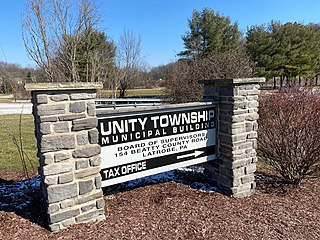
Unity Township is a township in Westmoreland County, Pennsylvania, United States. The population was 21,724 at the 2020 census, a decline of approximately 4% compared to the 2010 census.

Livermore, Pennsylvania is an abandoned town that was located on the Conemaugh River between Blairsville and Saltsburg in Derry Township, Westmoreland County, Pennsylvania. The town was abandoned and partially razed in the early 1950s following authorization by the Flood Control Act of 1936 and Flood Control Act of 1938 for construction of the Conemaugh Dam and Lake to prevent flooding of Pittsburgh. Much of the former town site now lies under the reservoir and floodplains.

<span class="mw-page-title-main">River Valley School District (Pennsylvania)</span> School district in Pennsylvania

River Valley School District is a small, rural school district that spans portions of two counties. In Indiana County it covers the Boroughs of Blairsville and Saltsburg and Black Lick Township, Burrell Township and Conemaugh Township. In Westmoreland County it covers Loyalhanna Township. The district encompasses approximately 142 square miles (370 km2). Per the 2000 Census, the district had approximately 16,000 residents. According to 2000 federal census data, it serves a resident population of 14,363 people. In 2009, the district residents’ per capita income was $15,663, while the median family income was $37,257. In the Commonwealth, the median family income was $49,501 and the United States median family income was $49,445, in 2010.

<span class="mw-page-title-main">Pennsylvania Route 217</span> State highway in Pennsylvania, US

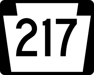
Pennsylvania Route 217 is a 21-mile-long (34 km) state highway located in Westmoreland and Indiana counties in Pennsylvania. The southern terminus is at U.S. Route 30 near Latrobe. The northern terminus is at PA 286 near Jacksonville.

<span class="mw-page-title-main">Pennsylvania House of Representatives, District 59</span> American legislative district

The 59th Pennsylvania House of Representatives District is located in southwest Pennsylvania and has been represented by Leslie Rossi since 2021.

<span class="mw-page-title-main">Greater Latrobe School District</span> School district in Pennsylvania

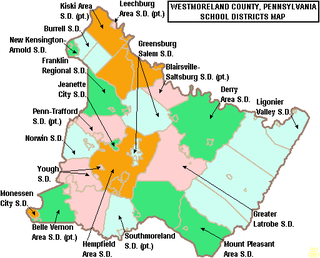
Greater Latrobe School District is a midsized, suburban public school district in Westmoreland County, Pennsylvania. The city of Latrobe and the borough of Youngstown as well as Unity Township are within district boundaries. Greater Latrobe School District encompasses approximately 69 square miles (180 km2). The community is a mix of Pittsburgh suburbia and rural areas.

<span class="mw-page-title-main">Bradenville, Pennsylvania</span> Census-designated place in Pennsylvania, United States

Bradenville is a census-designated place and coal town in Derry Township in Westmoreland County, Pennsylvania, United States. The community is located within two miles of the city of Latrobe and is three miles from the borough of Derry.

References

  1. "2016 U.S. Gazetteer Files". United States Census Bureau. Retrieved August 14, 2017.
  2. 1 2 "US 2020 Census".
  3. Bureau, U. S. Census. "U.S. Census website". United States Census Bureau . US Census Bureau. Retrieved December 1, 2019.
  4. 1 2 Boucher, John Newton (1906). History of Westmoreland county, Pennsylvania. New York: The Lewis Publishing Company. pp.  537-540.
  5. "Mid-Atlantic Karst Conservancy, Inc". www.karst.org. Retrieved October 26, 2018.
  6. "National Register Information System". National Register of Historic Places . National Park Service. July 9, 2010.
  7. 1 2 WilkinsServices.com, TJ Wilkins-. "Derry Township, Westmoreland County, PA". derrytownship.com.
  8. 1 2 "Pennsylvania Municipality Boundaries | PA Open Data Portal". Tyler Data & Insights.
  9. 1 2 3 4 "Derry Township · Pennsylvania". Derry Township · Pennsylvania.
  10. "Derry Township, State and Federal Officials". www.derrytownship.com.
  11. "U.S. Census website". United States Census Bureau . Retrieved January 31, 2008.

40°23′00″N79°13′59″W / 40.38333°N 79.23306°W / 40.38333; -79.23306