Westmoreland County is a county in the Commonwealth of Pennsylvania, United States. As of the 2020 census, the population was 364,663. The county seat is Greensburg. Formed from, successively, Lancaster, Northumberland, and later Bedford counties, Westmoreland County was founded on February 26, 1773, and was the first county in the colony of Pennsylvania whose entire territorial boundary was located west of the Allegheny Mountains. Westmoreland County originally included the present-day counties of Fayette, Washington, Greene, and parts of Beaver, Allegheny, Indiana, and Armstrong counties. It is named after Westmorland, a historic county of England.
Somerset County is a county in the Commonwealth of Pennsylvania. As of the 2020 census, the population was 74,129. Its county seat is Somerset. The county was created from part of Bedford County on April 17, 1795, and named after the county of Somerset in England.

Springfield Township is a township in Fayette County, Pennsylvania, United States. The population was 2,730 at the 2020 census. The Connellsville Area School District serves the township.

Middlecreek Township is a township in Somerset County, Pennsylvania, United States. The population was 831 at the 2020 census. It is part of the Johnstown, Pennsylvania, Metropolitan Statistical Area.

New Centerville is a borough in Somerset County, Pennsylvania, United States. The population was 127 at the 2020 census. It is part of the Johnstown, Pennsylvania, Metropolitan Statistical Area. It should not be confused with the unincorporated village of New Centerville in Tredyffrin Township.

The Laurel Highlands is a region in southwestern Pennsylvania made up of Fayette County, Somerset County, and Westmoreland County. It has a population of about 600,000 people.

Pennsylvania Route 31 is a 74-mile-long (119 km) state highway located in Western Pennsylvania, paralleling U.S. Route 30 and the Pennsylvania Turnpike for most of its length. The designation begins at PA 136 near West Newton and ends at US 30 near Bedford.

Charles Ogle was an Anti-Masonic and Whig member of the U.S. House of Representatives from Pennsylvania.
Kecksburg is an unincorporated community in Mount Pleasant Township, Westmoreland County, Pennsylvania, United States. Located in a heavily wooded area along PA Route 982, it is approximately thirty miles southeast of Pittsburgh at an elevation of 1,209 feet.

Pennsylvania Route 130 (PA 130) is a 49-mile-long (79 km) state highway located in Allegheny and Westmoreland counties in Pennsylvania. The western terminus is at PA 8 in Pittsburgh, and the eastern terminus is at PA 381 near Kregar.

Pennsylvania Route 711 is a 55-mile-long (89 km), north–south state highway located in Fayette, Westmoreland, and Indiana counties in Pennsylvania. The southern terminus is at U.S. Route 119 /PA 201 in Connellsville. The northern terminus is at PA 403 in East Wheatfield Township.
Old York Road is a roadway that was built during the 18th century to connect Philadelphia with New York City. Through New Jersey it was built along the Raritan "Naraticong Trail", also known as the Tuckaraming Trail. A memorial plaque to the friendship of the Naraticong Indians, who permitted the road to be built over their trail, is at the intersection of Old York Road and Canal in Raritan, NJ. The Swift Sure Stage Coach Line completed the journey between the two cities in two days and cost a few dollars.
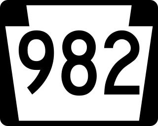
Pennsylvania Route 982 is a state highway which runs 32.15 miles across Fayette and Westmoreland counties, in southwestern Pennsylvania. The highway begins at U.S. Route 119 in Moyer, Pennsylvania, and runs northward into Westmoreland County, passing through the towns of Youngstown, Latrobe, and Derry before ending at US 22/US 119 near Blairsville.
Acme is an unincorporated community in Donegal, Mount Pleasant and Bullskin townships in Pennsylvania, United States. The Acme ZIP code of 15610 extends well beyond the more densely populated part of the area, into rural parts of Donegal Township in Westmoreland County and Bullskin Township in Fayette County.

South Petherton is a very large village and civil parish in the South Somerset district of Somerset, England, located 5 miles (8 km) east of Ilminster and 5 miles (8 km) north of Crewkerne. The parish had a population of 3,367 in 2011 and includes the smaller village of Over Stratton and the hamlets of Compton Durville, Drayton, Wigborough and Yeabridge. The River Parrett forms the eastern boundary of the parish. The village is approximately 2 miles (3 km) from East Lambrook, Martock and Lopen.

U.S. Route 119 (US 119) travels through Connellsville, Greensburg, and Punxsutawney, and bypasses Uniontown and Indiana. There are numerous other boroughs and villages along its 133-mile (214 km) route in the Keystone State. The southern entrance of US 119 is at the West Virginia state line one-half-mile south of Point Marion. The northern terminus is at US 219 two miles (3 km) south of DuBois, Pennsylvania. US 119 is in the National Highway System from the West Virginia state line to Exit 0 of PA Turnpike 66, and from US 22 to US 219. From US 22 to US 219, the highway carries the name of the Buffalo-Pittsburgh Highway; from US 22 to PA 56, it is also known as the Patrick J. Stapleton Highway; near Uniontown, it bears the name George C. Marshall Parkway.

Brenizer, also known as Breinizer, is an unincorporated community and coal town in Derry Township, Westmoreland County, Pennsylvania, United States.
Jacob's Creek Bridge was the first iron-chain suspension bridge built in the United States. Designed by James Finley, a local judge and inventor, it spanned Jacob's Creek, just south of Mount Pleasant, Pennsylvania. Nothing of the bridge is thought to remain, but an area on the north side of Jacob's Creek – where Route 819 crosses – is still called "Iron Bridge."
Jacobs Creek is an unincorporated community in Westmoreland County, Pennsylvania, United States. The community is located at the mouth of Jacobs Creek on the Youghiogheny River, 1.5 miles (2.4 km) south of Smithton. Jacobs Creek has a post office with ZIP code 15448, which opened on December 14, 1865.
Alverton is an unincorporated community in Westmoreland County, Pennsylvania, United States. The community is located along Pennsylvania Route 981, 2.5 miles (4.0 km) west of Mount Pleasant. Alverton has a post office, with ZIP code 15612.


