Lawson Heights, Pennsylvania

Last updated
Lawson Heights
CDP
USA Pennsylvania location map.svg
Red pog.svg
Lawson Heights
Location within the U.S. state of Pennsylvania
Coordinates: 40°17′37″N79°23′7″W / 40.29361°N 79.38528°W / 40.29361; -79.38528
Country United States
State Pennsylvania
County Westmoreland
Area
[1]
  Total1.53 sq mi (3.96 km2)
  Land1.53 sq mi (3.96 km2)
  Water0.00 sq mi (0.00 km2)
Population
 (2020) [2]
  Total2,090
  Density1,366.01/sq mi (527.56/km2)
Time zone UTC-5 (Eastern (EST))
  Summer (DST) UTC-4 (EDT)
FIPS code 42-42032

Lawson Heights is a census-designated place (CDP) in Unity Township, Westmoreland County, Pennsylvania, United States. The population was 2,339 at the 2000 census.

Contents

Geography

Lawson Heights is located at 40°17′37″N79°23′7″W / 40.29361°N 79.38528°W / 40.29361; -79.38528 (40.293713, -79.385312). [3]

According to the United States Census Bureau, the CDP has a total area of 1.5 square miles (3.9 km2), all land.

Demographics

Historical population
CensusPop.Note
2020 2,090
U.S. Decennial Census [4]

At the 2000 census there were 2,339 people, 1,018 households, and 701 families living in the CDP. The population density was 1,524.4 inhabitants per square mile (588.6/km2). There were 1,064 housing units at an average density of 693.5 per square mile (267.8/km2). The racial makeup of the CDP was 98.80% White, 0.21% African American, 0.13% Native American, 0.21% Asian, 0.04% Pacific Islander, 0.04% from other races, and 0.56% from two or more races. Hispanic or Latino of any race were 0.43%. [5]

Of the 1,018 households 21.0% had children under the age of 18 living with them, 58.2% were married couples living together, 7.9% had a female householder with no husband present, and 31.1% were non-families. 29.2% of households were one person and 17.2% were one person aged 65 or older. The average household size was 2.24 and the average family size was 2.73.

The age distribution was 17.9% under the age of 18, 5.6% from 18 to 24, 22.7% from 25 to 44, 25.8% from 45 to 64, and 28.0% 65 or older. The median age was 48 years. For every 100 females, there were 88.6 males. For every 100 females age 18 and over, there were 84.2 males.

The median household income was $37,158 and the median family income was $49,766. Males had a median income of $37,989 versus $25,125 for females. The per capita income for the CDP was $19,027. About 4.4% of families and 6.5% of the population were below the poverty line, including 9.4% of those under age 18 and 7.9% of those age 65 or over.

See also

Related Research Articles

<span class="mw-page-title-main">East San Gabriel, California</span> Census-designated place in California, United States

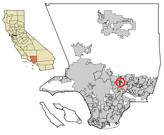
East San Gabriel is a census-designated place (CDP) in Los Angeles County, California, United States. The population was 14,874 at the 2010 census, up from 14,512 at the 2000 census.

<span class="mw-page-title-main">Kahaluʻu-Keauhou, Hawaii</span> Census-designated place in Hawaii, U.S.

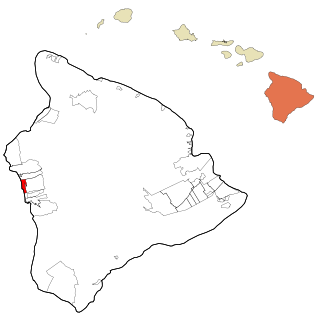
Kahaluʻu-Keauhou is a census-designated place (CDP) in Hawaiʻi County, Hawaii, United States. The population was 3,549 at the 2010 census, up from 2,414 at the 2000 census.

<span class="mw-page-title-main">South Miami Heights, Florida</span> Census-designated place in Florida, United States

South Miami Heights is a census-designated place (CDP), originally known as Eureka, in Miami-Dade County, Florida. The population was 36,770 as of the 2020 census.

<span class="mw-page-title-main">Leisure Knoll, New Jersey</span> Census-designated place in New Jersey, United States

Leisure Knoll is an unincorporated community and census-designated place (CDP) located within Manchester Township, in Ocean County, New Jersey, United States. As of the 2010 United States Census, the CDP's population was 2,490.

<span class="mw-page-title-main">Curtisville, Pennsylvania</span> Census-designated place in Pennsylvania, United States

Curtisville is a census-designated place (CDP) in Allegheny County, Pennsylvania, United States. The population was 1,097 at the 2020 census.

<span class="mw-page-title-main">Russellton, Pennsylvania</span> Census-designated place in Pennsylvania, United States

Russellton is a census-designated place (CDP) in Allegheny County, Pennsylvania, United States. The population was 1,330 at the 2020 census.

<span class="mw-page-title-main">Lenape Heights, Pennsylvania</span> Census-designated place in Pennsylvania, United States

Lenape Heights is a census-designated place (CDP) in Armstrong County, Pennsylvania, United States. The population was 1,167 at the 2010 census.

<span class="mw-page-title-main">Orchard Hills, Pennsylvania</span> Census-designated place in Pennsylvania, United States

Orchard Hills is a census-designated place (CDP) in Armstrong County, Pennsylvania, United States. The population was 1,952 at the 2010 census.

<span class="mw-page-title-main">West Hills, Pennsylvania</span> Census-designated place in Pennsylvania, United States

West Hills is a census-designated place (CDP) in Armstrong County, Pennsylvania, United States. The population was 1,263 at the 2010 census.

<span class="mw-page-title-main">Nixon, Pennsylvania</span> Census-designated place in Pennsylvania, United States

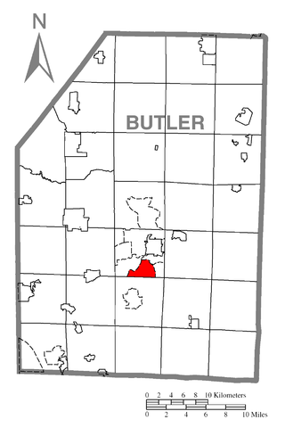
Nixon is a census-designated place (CDP) in Butler County, Pennsylvania, United States. The population was 1,373 at the 2010 census.

<span class="mw-page-title-main">Oak Hills, Pennsylvania</span> Census-designated place in Pennsylvania, United States

Oak Hills is a census-designated place (CDP) in Butler County, Pennsylvania, United States. The population was 2,333 at the 2010 census.

Black Lick is a census-designated place (CDP) in Burrell Township, Indiana County, Pennsylvania, United States. The population was 1,462 at the 2010 census.

<span class="mw-page-title-main">Lucerne Mines, Pennsylvania</span> Census-designated place in Pennsylvania, United States

Lucernemines, usually written as Lucerne Mines, is a census-designated place (CDP) in Indiana County, Pennsylvania, United States. The population was 937 at the 2010 census.

<span class="mw-page-title-main">Baidland, Pennsylvania</span> Census-designated place in Pennsylvania, United States

Baidland is a census-designated place (CDP) in Washington County, Pennsylvania, United States. The population was 1,563 at the 2010 census.

<span class="mw-page-title-main">Wickerham Manor-Fisher, Pennsylvania</span> Census-designated place in Pennsylvania, United States

Wickerham Manor-Fisher is a census-designated place (CDP) in Washington County, Pennsylvania, United States. The population was 1,728 at the 2010 census.

<span class="mw-page-title-main">Harrison City, Pennsylvania</span> Census-designated place in Pennsylvania, United States

Harrison City is a census-designated place (CDP) in Westmoreland County, Pennsylvania, United States. The population was 174 at the 2020 census.

Loyalhanna is a census-designated place (CDP) in Westmoreland County, Pennsylvania, United States. The population was 3,415 at the 2000 census, at which time it was listed as McChesneytown-Loyalhanna, before just becoming the CDP of Loyalhanna for the 2010 census. As of the 2010 census the population was 3,428 residents.

<span class="mw-page-title-main">South Sumter, South Carolina</span> CDP in South Carolina, United States

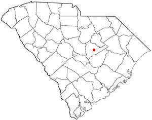
South Sumter is a census-designated place (CDP) in Sumter County, South Carolina, United States. The population was 3,365 at the 2000 census. It is included in the Sumter, South Carolina Metropolitan Statistical Area.

Villa Heights is a census-designated place (CDP) in Henry County, Virginia, United States. The population was 717 at the 2010 census. It is part of the Martinsville Micropolitan Statistical Area.

<span class="mw-page-title-main">Brewster (CDP), Massachusetts</span> Census-designated place in Massachusetts, United States

Brewster is a census-designated place (CDP) in the town of Brewster in Barnstable County, Massachusetts, United States. The population was 2,000 at the 2010 census, out of 9,820 in the town of Brewster as a whole.

References

  1. "ArcGIS REST Services Directory". United States Census Bureau. Retrieved October 12, 2022.
  2. "Census Population API". United States Census Bureau. Retrieved Oct 12, 2022.
  3. "US Gazetteer files: 2010, 2000, and 1990". United States Census Bureau. 2011-02-12. Retrieved 2011-04-23.
  4. "Census of Population and Housing". Census.gov. Retrieved June 4, 2016.
  5. "U.S. Census website". United States Census Bureau . Retrieved 2008-01-31.