Loyalhanna, Pennsylvania

Last updated

Loyalhanna, Pennsylvania
USA Pennsylvania location map.svg
Red pog.svg
Loyalhanna, Pennsylvania
Location within the U.S. state of Pennsylvania
Coordinates: 40°18′51″N79°21′41″W / 40.31417°N 79.36139°W / 40.31417; -79.36139
Country United States
State Pennsylvania
County Westmoreland
Area
[1]
  Total2.35 sq mi (6.10 km2)
  Land2.35 sq mi (6.10 km2)
  Water0.00 sq mi (0.00 km2)
Population
 (2020) [2]
  Total3,409
  Density1,447.56/sq mi (559.00/km2)
Time zone UTC-5 (Eastern (EST))
  Summer (DST) UTC-4 (EDT)
ZIP code
15661 [3]
Area code 724
FIPS code 42-45192

Loyalhanna is a census-designated place (CDP) in Westmoreland County, Pennsylvania, United States. The population was 3,415 at the 2000 census, at which time it was listed as McChesneytown-Loyalhanna, before just becoming the CDP of Loyalhanna for the 2010 census. As of the 2010 census the population was 3,428 residents.

Contents

Geography

Loyalhanna is located at 40°18′51″N79°21′41″W / 40.31417°N 79.36139°W / 40.31417; -79.36139 (40.314197, -79.361280). [4]

According to the United States Census Bureau, the CDP has a total area of 2.3 square miles (6.0 km2), all land.

Demographics

Historical population
CensusPop.Note
2020 3,409
U.S. Decennial Census [5]

As of the census [6] of 2000, there were 3,415 people, 1,464 households, and 1,030 families residing in the CDP. The population density was 1,462.3 inhabitants per square mile (564.6/km2). There were 1,536 housing units at an average density of 657.7 per square mile (253.9/km2). The racial makeup of the CDP was 99.33% White, 0.26% African American, 0.03% Native American, 0.18% Asian, and 0.20% from two or more races. Hispanic or Latino of any race were 0.20% of the population.

There were 1,464 households, out of which 24.7% had children under the age of 18 living with them, 56.4% were married couples living together, 10.0% had a female householder with no husband present, and 29.6% were non-families. 26.4% of all households were made up of individuals, and 14.5% had someone living alone who was 65 years of age or older. The average household size was 2.31 and the average family size was 2.78.

In the CDP, the population was spread out, with 19.7% under the age of 18, 5.8% from 18 to 24, 26.6% from 25 to 44, 26.1% from 45 to 64, and 21.9% who were 65 years of age or older. The median age was 44 years. For every 100 females, there were 92.7 males. For every 100 females age 18 and over, there were 89.0 males.

The median income for a household in the CDP was $34,018, and the median income for a family was $40,845. Males had a median income of $32,292 versus $21,849 for females. The per capita income for the CDP was $18,041. About 6.0% of families and 7.5% of the population were below the poverty line, including 10.7% of those under age 18 and 7.6% of those age 65 or over.

Related Research Articles

<span class="mw-page-title-main">Wahneta, Florida</span> Census-designated place in Florida, United States

Wahneta is a census-designated place (CDP) in central Polk County, Florida, United States. The population was 4,731 at the 2000 census. It is part of the Lakeland–Winter Haven Metropolitan Statistical Area.

<span class="mw-page-title-main">Paukaa, Hawaii</span> Census-designated place in Hawaii, U.S.

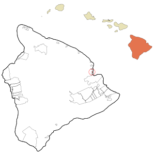
Paukaʻa is a census-designated place (CDP) in Hawaii County, Hawaii, United States. The population was 425 at the 2010 census, down from 495 at the 2000 census. The ZIP code is 96720.

<span class="mw-page-title-main">North Lakeville, Massachusetts</span> Census-designated place in Massachusetts, United States

North Lakeville is a census-designated place (CDP) in the town of Lakeville in Plymouth County, Massachusetts, United States. The population was 2,630 at the 2010 census.

<span class="mw-page-title-main">Weweantic, Massachusetts</span> Census-designated place in Massachusetts, United States

Weweantic is a census-designated place (CDP) in the town of Wareham in Plymouth County, Massachusetts, United States. The population was 2,105 at the 2010 census.

<span class="mw-page-title-main">Yorketown, New Jersey</span> Populated place in Monmouth County, New Jersey, US

Yorketown is an unincorporated community and census-designated place (CDP) within Manalapan Township, in Monmouth County, in the U.S. state of New Jersey. At the 2020 census, the CDP's population was 6,739.

<span class="mw-page-title-main">Fruit Hill, Ohio</span> Census-designated place in Ohio, United States

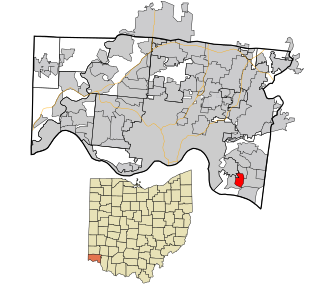
Fruit Hill is a census-designated place (CDP) in Hamilton County, Ohio, United States. The population was 3,748 at the 2020 census.

<span class="mw-page-title-main">West Peavine, Oklahoma</span> Census-designated place in Oklahoma, United States

West Peavine is a census-designated place (CDP) in Adair County, Oklahoma, United States. The population was 218 at the 2010 census.

<span class="mw-page-title-main">Lenape Heights, Pennsylvania</span> Census-designated place in Pennsylvania, United States

Lenape Heights is a census-designated place (CDP) in Armstrong County, Pennsylvania, United States. The population was 1,144 at the 2020 census.

<span class="mw-page-title-main">Guys Mills, Pennsylvania</span> Census-designated place in Pennsylvania, United States

Guys Mills is a census-designated place in Crawford County, Pennsylvania, United States. The population was 124 at the 2010 census.

Black Lick is a census-designated place (CDP) in Burrell Township, Indiana County, Pennsylvania, United States. The population was 1,462 at the 2010 census.

Jacksonville is a census-designated place (CDP) in Indiana County, Pennsylvania, United States. The population was 637 at the 2010 census. It was formerly an independent borough, until January 1, 1993 when it was returned to Black Lick Township, Pennsylvania.

<span class="mw-page-title-main">Lucerne Mines, Pennsylvania</span> Census-designated place in Pennsylvania, United States

Lucernemines, usually written as Lucerne Mines, is a census-designated place (CDP) in Indiana County, Pennsylvania, United States. The population was 937 at the 2010 census.

<span class="mw-page-title-main">Oakland, Lawrence County, Pennsylvania</span> Census-designated place in Pennsylvania, United States

Oakland is an unincorporated area and census-designated place (CDP) in Lawrence County, Pennsylvania, United States. The population was 1,569 at the 2010 census.

<span class="mw-page-title-main">Baidland, Pennsylvania</span> Census-designated place in Pennsylvania, United States

Baidland is a census-designated place (CDP) in Washington County, Pennsylvania, United States. The population was 1,563 at the 2010 census.

<span class="mw-page-title-main">Wickerham Manor-Fisher, Pennsylvania</span> Census-designated place in Pennsylvania, United States

Wickerham Manor-Fisher is a census-designated place (CDP) in Washington County, Pennsylvania, United States. The population was 1,728 at the 2010 census.

<span class="mw-page-title-main">Harrison City, Pennsylvania</span> Census-designated place in Pennsylvania, United States

Harrison City is a census-designated place (CDP) in Westmoreland County, Pennsylvania, United States. The population was 174 at the 2020 census.

<span class="mw-page-title-main">Loyalhanna Township, Pennsylvania</span> Township in Pennsylvania, United States

Loyalhanna Township is a township in Westmoreland County, Pennsylvania, United States. As of the 2020 census, the township's total population was 2,093.

<span class="mw-page-title-main">New Alexandria, Pennsylvania</span> Borough in Pennsylvania, United States

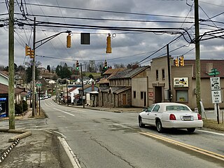
New Alexandria is a borough that is located in Westmoreland County, Pennsylvania, United States. The population was 560 at the time of the 2010 census.

<span class="mw-page-title-main">West Alto Bonito, Texas</span> CDP in Texas, United States

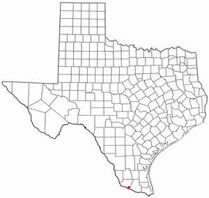
West Alto Bonito is a census-designated place (CDP) in Starr County, Texas, United States. The population was 696 in 2010 census. Prior to the 2010 census, West Alto Bonito CDP was known as Alto Bonito CDP.

<span class="mw-page-title-main">Hanson (CDP), Massachusetts</span> Census-designated place in Massachusetts, United States

Hanson is a census-designated place (CDP) in the town of Hanson in Plymouth County, Massachusetts, United States. The population was 2,118 at the 2010 census.

References

  1. "ArcGIS REST Services Directory". United States Census Bureau. Retrieved October 12, 2022.
  2. "Census Population API". United States Census Bureau. Retrieved October 12, 2022.
  3. "Loyalhanna PA ZIP Code". zipdatamaps.com. 2023. Retrieved May 13, 2023.
  4. "US Gazetteer files: 2010, 2000, and 1990". United States Census Bureau. February 12, 2011. Retrieved April 23, 2011.
  5. "Census of Population and Housing". Census.gov. Retrieved June 4, 2016.
  6. "U.S. Census website". United States Census Bureau . Retrieved January 31, 2008.