Jeannette, Pennsylvania

Last updated

Jeannette, Pennsylvania
City
Jeannette-pennsylvania-downtown.jpg
Jeannette's Business District (Clay Avenue)
Westmoreland County Pennsylvania Incorporated and Unincorporated areas Jeannette Highlighted.svg
Location of Jeannette in Westmoreland County, Pennsylvania.
USA Pennsylvania location map.svg
Red pog.svg
Jeannette, Pennsylvania
Coordinates: 40°19′44″N79°36′50″W / 40.32889°N 79.61389°W / 40.32889; -79.61389
Country United States
State Pennsylvania
County Westmoreland
Settled1888
Incorporated (borough)June 7, 1889
Incorporated (city)January 1, 1938
Government
  TypeCity Council
Area
[1]
  Total2.39 sq mi (6.18 km2)
  Land2.39 sq mi (6.18 km2)
  Water0.00 sq mi (0.00 km2)
Population
 (2020) [2]
  Total8,780
  Density3,676.72/sq mi (1,419.81/km2)
Time zone UTC-5 (Eastern (EST))
  Summer (DST) UTC-4 (EDT)
Zip code
15644
FIPS code 42-37784
Website City of Jeannette

Jeannette is a city in Westmoreland County, Pennsylvania, United States. Jeannette was founded in 1888. [3] The city got its name from one of the original city fathers, H. Sellers McKee, who wished to honor his wife by giving the new town her first name: Jeannette. [3] The city celebrated its 125th anniversary in July 2013. [3] The population was 9,654 according to the 2010 census.

Contents

Geography

Jeannette is located at 40°19′44″N79°36′50″W / 40.32889°N 79.61389°W / 40.32889; -79.61389 (40.328773, -79.613997). [4]

According to the United States Census Bureau, the city has a total area of 2.39 square miles (6.2 km2), all land.

Demographics

Historical population
CensusPop.Note
1890 3,296
1900 5,86577.9%
1910 8,07737.7%
1920 10,62731.6%
1930 15,12642.3%
1940 16,2207.2%
1950 16,172−0.3%
1960 16,5652.4%
1970 15,209−8.2%
1980 13,106−13.8%
1990 11,221−14.4%
2000 10,654−5.1%
2010 9,654−9.4%
2020 8,780−9.1%
Sources: [5] [6] [7] [2]

As of the census [7] of 2010, there were 9,654 people, 4,630 households, and 2,949 families residing in the city. The population density was 4,414.3 inhabitants per square mile (1,704.4/km2). There were 5,139 housing units at an average density of 2,129.3 per square mile (822.1/km2). The racial makeup of the city was 77.81% white, 20.19% African American, 0.08% Native American, 0.09% Asian, 0.04% Pacific Islander, 0.20% from other races, and 1.60% from two or more races. Hispanic or Latino of any race were 0.50% of the population.

There were 4,630 households, out of which 26.7% had children under the age of 18 living with them, 45.3% were married couples living together, 14.9% had a female householder with no husband present, and 36.3% were non-families. 32.4% of all households were made up of individuals, and 15.9% had someone living alone who was 65 years of age or older. The average household size was 2.29 and the average family size was 2.89.

In the city, the population was spread out, with 22.1% under the age of 18, 7.4% from 18 to 24, 28.4% from 25 to 44, 22.2% from 45 to 64, and 20.0% who were 65 years of age or older. The median age was 40 years. For every 100 females, there were 87.6 males. For every 100 females age 18 and over, there were 83.5 males.

The median income for a household in the city in 2011 was $31,498. The median income for a family was $37, 038. Males had a median income of $32,413 versus $21,702 for females. The per capita income for the city was $15,961. About 10.9% of families and 15.0% of the population were below the poverty line, including 21.2% of those under age 18 and 13.2% of those age 65 or over.

Civic life

City government and services

Public safety and living standards

Religious life

In 1943, the city went before the Supreme Court to defend an ordinance that banned distributing religious materials door to door. Several members of the Jehovah's Witnesses challenged the constitutionality of the law but were defeated in Douglas v. City of Jeannette .

Education

Jeannette City School District includes McKee Elementary School and Jeannette Junior/Senior High School. [12]

History

Perhaps the oldest historical reference to the area that became Jeannette is the role the area played in the Pontiac War in 1763. The Bushy Run Battlefield marks the spot where Colonel Henry Boquet led the British and American troops to defeat the Indians in a battle on the 5th and 6 August that year. This victory is credited with helping to prevent the capture of Fort Pitt, and it served the purpose of reopening communication and supply lines. Today, this 200-acre (0.81 km2) historical landmark is the site of a museum, nature trails, picnic areas, and an annual reenactment of the Battle of Bushy Run.

McKee Glass Factory, late 1880s McKee Glass-Late-1880s-Jeannette-By-Terry-Perich-John-Howard-.png
McKee Glass Factory, late 1880s

First incorporated as a borough on June 7, 1889, [13] Jeannette earned the nickname as "the glass city" in recognition of the numerous glass plants founded in the area, with those factories contributing to the city's original stature as the first large manufacturing town in Westmoreland County. In fact, the impact of the glass industry was so significant that the city's name actually comes from Jeannette E. Hartupee McKee, the wife of H. Sellers McKee, a local industrialist who cofounded the Chambers and McKee Glass Works [14] and was a member of the elite South Fork Fishing and Hunting Club of Johnstown Flood fame. [15] Mckee and his partner J.A. Chambers also have the distinction of naming Jeannette's main street, Clay Avenue after their financial backer, Richard W. Clay. On January 1, 1938, Jeannette became a third class city with Attorney John M. OConnell as the first mayor. [16]

At times, there were as many as 7 significant factories operating in the city of Jeannette including some of the most well known in the history of the glass industry. Names like Jeannette Glass; Fort Pitt Glass; the Pittsburgh Lamp, Brass and Glass Company; American-Saint Gobain, Westmoreland Glass; and others all supplied the country with everything from plate glass windows, to bottles, to milk glass, and much more for many decades. Some estimates over the years indicate that Jeannette once produced somewhere between 70 and 85% of the world's glass. Unfortunately, Jeannette's glass industry was one of the early United States industry victims of cheap, foreign competition that made it less expensive to produce glass overseas and today only two glass factories remain in the city.

Jeannette's manufacturing history doesn't end with the glass industry. Today's Elliott Company represents an evolution dating back to 1914 when William Swan Elliott moved his company to Jeannette. The Elliott Company, owned by the Carrier Corporation from 1957 until 1979 and by United Technologies Corporation until a 1987 buyout that returned the company to a privately owned status, only to become an Ebara Corporation subsidiary in 2000, has always had a solid reputation in the dynamo, turbine, and large rotating equipment industry. In 1952, the company produced the first diesel-engine turbocharger used in a racecar and subsequently built more than 40,000 more of them for other diesel applications. Throughout the 1970s, local residents routinely witnessed a revolving door of trains hauling parts into the plant on North 4th Street and hauling the huge turbine engines back down the tracks. [17] Today, the Elliott Company is the city's largest employer. [16] Jeannette is also the manufacturing home of Jensen Steam Engine Mfg. Co., Inc., which produces small working models of steam engines and turbines. The Jensen shop is only a few blocks from the Elliott plant.

Monsour Medical Center was a 100-bed hospital when it opened in Jeannette, Pennsylvania, in 1958. The Hospital was state-of-the-art in its day, but later fell into financial trouble and was closed in the early 2000's.

In 2018, the Elliott Company was approved to purchase the former Jeannette Glass site and expand their operations to downtown Jeannette. [18] The facility could become operational by 2020. [19]

The Pennsylvania Rubber Works, which moved to Jeannette from Erie, Pennsylvania, around 1903, was yet another key part of the city's significant industrial base. Not only did this factory become a significant supplier of play balls (basketballs, footballs, tennis balls, etc.) and carpet underlay as part of General Tire in its later years; but the original Pennsylvania Rubber Works provided products for Jeeps and gas masks during World War II. [13]

Notable people

Related Research Articles

<span class="mw-page-title-main">Westmoreland County, Pennsylvania</span> County in Pennsylvania, United States

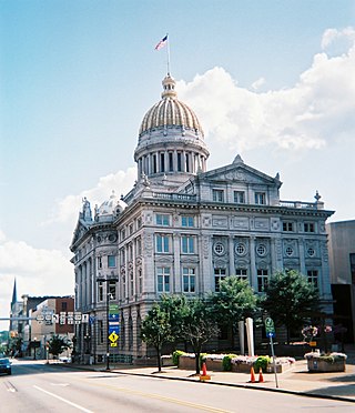
Westmoreland County is a county in the Commonwealth of Pennsylvania, United States, located in the Pittsburgh Metropolitan Statistical Area. As of the 2020 census, the population was 354,663. The county seat is Greensburg and the most populous community is Hempfield Township. It is named after Westmorland, a historic county of England.

<span class="mw-page-title-main">Coraopolis, Pennsylvania</span> Borough in Pennsylvania, United States

Coraopolis is a borough in Allegheny County, Pennsylvania, United States, along the Ohio River. The population was 5,559 at the 2020 census.

<span class="mw-page-title-main">Westmoreland, Kansas</span> City in Pottawatomie County, Kansas

Westmoreland is a city in and the county seat of Pottawatomie County, Kansas, United States. As of the 2020 census, the population of the city was 740.

<span class="mw-page-title-main">Glassport, Pennsylvania</span> Borough in Allegheny County, Pennsylvania

Glassport is a borough in Allegheny County, Pennsylvania, United States, approximately 10 miles (16 km) south of Pittsburgh and the confluence of the Monongahela and Allegheny rivers where they form the Ohio River. Glassport lies along the east side of the Monongahela River in the "Mon Valley", where many blue-collar municipalities have suffered severe economic decline in the wake of the loss of steel-making throughout the Greater Pittsburgh area. In 1910, the population of Glassport was 5,540. By 1940, it had risen to 8,748, but has since declined to 4,475 as of the 2020 census.

<span class="mw-page-title-main">McKees Rocks, Pennsylvania</span> Borough in Pennsylvania, United States

McKees Rocks, also known as "The Rocks", is a borough in Allegheny County in Western Pennsylvania, United States, along the south bank of the Ohio River. Part of the Pittsburgh metropolitan area, its population was 5,920 at the time of the 2020 census.

<span class="mw-page-title-main">Tarentum, Pennsylvania</span> Borough in Pennsylvania, United States

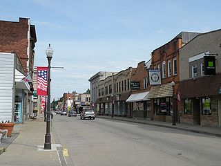
Tarentum is a borough in Allegheny County in the U.S. state of Pennsylvania. It is 22 miles (35 km) northeast of Downtown Pittsburgh, along the Allegheny River. Tarentum was an industrial center where plate glass and bottles were manufactured; bricks, lumber, steel and iron novelties, steel billets and sheets, sack and wrapping paper were also produced.

<span class="mw-page-title-main">Rochester, Pennsylvania</span> Borough in Pennsylvania

Rochester is a borough in central Beaver County, Pennsylvania, United States, at the confluence of the Beaver and Ohio rivers. Located 25 miles (40 km) northwest of Pittsburgh, it is part of the Pittsburgh metropolitan area. The population was 3,472 at the 2020 census.

<span class="mw-page-title-main">Belle Vernon, Pennsylvania</span> Borough in Pennsylvania, United States

Belle Vernon is a borough in Fayette County, Pennsylvania, United States. It is situated along the Monongahela River, abutting two other counties, Westmoreland to the north and Washington across the river. As of the 2020 census, Belle Vernon had a population of 1,025.

<span class="mw-page-title-main">Charleroi, Pennsylvania</span> Borough in Pennsylvania, United States

Charleroi is a borough in Washington County, Pennsylvania, United States, along the Monongahela River, 21 miles south of Pittsburgh.

<span class="mw-page-title-main">Donora, Pennsylvania</span> Borough in Pennsylvania, United States

Donora is a borough in Washington County, Pennsylvania, United States, approximately 20 miles (32 km) south of Pittsburgh along the Monongahela River. The population was 4,558 as of the 2020 census.

<span class="mw-page-title-main">Derry, Pennsylvania</span> Borough in Pennsylvania, United States

Derry is a borough in Westmoreland County in Pennsylvania, 45 miles (72 km) east of Pittsburgh. The Borough of Derry, consisting of the town area, should not be confused with Derry Township, which is a separate municipality surrounding the borough. The population was 2,637 at the 2020 census.

<span class="mw-page-title-main">Donegal Township, Westmoreland County, Pennsylvania</span> Township in Pennsylvania, United States

Donegal Township is a township in Westmoreland County, Pennsylvania, United States. The population was 2,192 at the 2020 census, a decrease of 9% compared to 2010.

<span class="mw-page-title-main">Hempfield Township, Westmoreland County, Pennsylvania</span> Township in Pennsylvania, United States

Hempfield Township is a township in Westmoreland County, Pennsylvania, United States. The population was 41,585 at the 2020 census, making it the largest suburb in the Pittsburgh Metropolitan Area by population. Its name is derived from Hempfield in Lancaster County, which was formed in 1729 and is named after the hemp fields in the area.

<span class="mw-page-title-main">Monessen, Pennsylvania</span> City in Pennsylvania, United States

Monessen is a city in southwestern Westmoreland County, Pennsylvania, United States, located along the Monongahela River. The population was 6,876 at the 2020 census.

<span class="mw-page-title-main">Penn, Pennsylvania</span> Borough in Pennsylvania, United States

Penn is a borough in Westmoreland County, Pennsylvania, United States. The population was 475 at the time of the 2010 census.

<span class="mw-page-title-main">Slickville, Pennsylvania</span> CDP in Pennsylvania, United States

Slickville is a census-designated place (CDP) in Westmoreland County, Pennsylvania, United States. The population was 372 at the 2000 census.

<span class="mw-page-title-main">Smithton, Pennsylvania</span> Borough in Pennsylvania, United States

Smithton is a borough in Westmoreland County, Pennsylvania, United States. The population was 399 at the 2010 census. As of 2018, the population was listed at 378. Smithton has its own post office, with zip code 15479, and is serviced by Yough School District.

<span class="mw-page-title-main">Unity Township, Pennsylvania</span> Township in Pennsylvania, United States

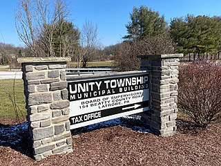
Unity Township is a township in Westmoreland County, Pennsylvania, United States. The population was 21,724 at the 2020 census, a decline of approximately 4% compared to the 2010 census.

<span class="mw-page-title-main">Washington Township, Westmoreland County, Pennsylvania</span> Township in Pennsylvania, United States

Washington Township is a township in Westmoreland County, Pennsylvania, United States. It was founded in 1789 from Salem Township. At that time, it included the present-day municipalities of Allegheny, Lower Burrell, Upper Burrell, and most of Bell. In 2020, the population of Washington Twp was 6,887.

<span class="mw-page-title-main">Trafford, Pennsylvania</span> Borough in Pennsylvania, United States

Trafford is a borough in Allegheny and Westmoreland counties in the U.S. state of Pennsylvania. Located near Pittsburgh in western Pennsylvania, the borough lies primarily in Westmoreland County; only a small portion extends into Allegheny County. It was incorporated in 1904 from the northernmost corner of North Huntingdon Township, and was named by George Westinghouse for Trafford near Manchester, England. Westinghouse purchased the land in 1902, and the Trafford Foundry began operations on October 3, 1903. The population was 3,317 at the 2020 census. Of this, 3,113 were in Westmoreland County, and only 61 were in Allegheny County.

References

  1. "ArcGIS REST Services Directory". United States Census Bureau. Retrieved October 12, 2022.
  2. 1 2 "Census Population API". United States Census Bureau. Retrieved October 12, 2022.
  3. 1 2 3 "About Jeannette". City of Jeannette.
  4. "US Gazetteer files: 2010, 2000, and 1990". United States Census Bureau. February 12, 2011. Retrieved April 23, 2011.
  5. "Number of Inhabitants: Pennsylvania" (PDF). 18th Census of the United States. U.S. Census Bureau. Retrieved November 22, 2013.
  6. "Pennsylvania: Population and Housing Unit Counts" (PDF). U.S. Census Bureau. Retrieved November 22, 2013.
  7. 1 2 "U.S. Census website". United States Census Bureau . Retrieved January 31, 2008.
  8. "Park/Recreation - City of Jeannette, Altman Park, Summer Activities". Archived from the original on March 7, 2014. Retrieved March 6, 2014.
  9. "Public Works". City of Jeannette.
  10. "Recycling is Mandatory - City of Jeannette, Newspaper, Aluminum Cans". Archived from the original on March 7, 2014. Retrieved March 6, 2014.
  11. "Community Development". City of Jeannette.
  12. "http://www.jeannetteschooldistrict.org". Archived from the original on January 19, 2022. Retrieved June 14, 2011.{{cite web}}: External link in |title= (help)
  13. 1 2 "Jeannette hopes to reclaim glory of manufacturing heyday" Archived 2008-02-27 at the Wayback Machine , Tribune Review, January 28, 2007
  14. "SUBSTREET - McKee Glass WorksJeannette, PA". November 5, 2015.
  15. "Jeanette, PA". homepages.rootsweb.com.
  16. 1 2 Great Towns in Westmoreland, "Jeannette A Great Town in Westmoreland County"
  17. A History of Accomplishments, Elliott Company Website
  18. "Pennsylvania’s ‘glass city’ finds footing in battle against Rust Belt hardships" Diana DiGangi
  19. "Westmoreland: Big projects, big changes on the horizon", Signorini, Renatta
  20. Ron Terpko (November 17, 2009). "WWII MEDAL OF HONOR WILLAM A. SHOMO". Archived from the original on December 11, 2021 via YouTube.