South Greensburg, Pennsylvania

Last updated

South Greensburg, Pennsylvania
Borough
South-greensburg-pennsylvania-business-district.jpg
The borough's business district (Broad Street)
Westmoreland County Pennsylvania Incorporated and Unincorporated areas South Greensburg Highlighted.svg
Location of South Greensburg in Westmoreland County, Pennsylvania.
USA Pennsylvania location map.svg
Red pog.svg
South Greensburg, Pennsylvania
Coordinates: 40°16′38″N79°32′55″W / 40.27722°N 79.54861°W / 40.27722; -79.54861
Country United States
State Pennsylvania
County Westmoreland
Settled1780
Incorporated1891
Government
  TypeBorough Council
Area
[1]
  Total0.71 sq mi (1.83 km2)
  Land0.71 sq mi (1.83 km2)
  Water0.00 sq mi (0.00 km2)
Elevation
1,073 ft (327 m)
Population
 (2010)
  Total2,117
  Estimate 
(2019) [2]
1,996
  Density2,823.20/sq mi (1,090.18/km2)
Time zone UTC-5 (Eastern (EST))
  Summer (DST) UTC-4 (EDT)
Zip code
15601
Area code 724
FIPS code 42-72192
Website www.southgreensburg.org
The borough's oldest structure:
The Rugh House at 1213 Broad Street South-greensburg-pennsylvania-oldest-house.jpg
The borough's oldest structure:
The Rugh House at 1213 Broad Street

South Greensburg is a borough in Westmoreland County, Pennsylvania, United States. The population was 2,117 at the 2010 census.

Contents

History

Early history

In 1780, Michael Rugh acquired title to 229.25 acres (0.9277 km2), which he operated as a farm. The land was passed on to his son, Jacob Rugh, and later to Jacob's son, Peter Rugh. The Rugh family house is still extant at 1213 Broad Street. [3] The current building dates from the Civil War, but was built on the foundation of a much older structure. The area was known as Rughtown, although it was not yet a town in any meaningful sense.

In the 1870s, a local industrialist, George Franklin Huff, bought 189 acres (0.76 km2) of the Rugh farm. In 1881, this was sold to Greensburg Coal and Coke Company (later Keystone Coal and Coke Company), which established a mine and brickyard along Broad Street. [4] Fifty workers' houses were built in 1888. During this time, the community was known as Huff, Hufftown, or, Pennsylvania Huff's Station.

A trolley line was constructed in 1890 along Broad Street, running north into Greensburg. This line was later acquired by West Penn Railways, which operated trolley service until 1952.

In 1891, the community was incorporated as the Borough of South Greensburg.

Coal strike of 1910-1911

The borough was the scene of violence during the Westmoreland County Coal Strike of 1910–1911. In July 1910, a group of striking coal miners were authorized to conduct a protest by the borough's Chief of Police, William B. Keltz. [5] A confrontation ensued between the marchers and security personnel working for Jamison Coal and Coke Company. In the resulting melee, one miner, Peter Gale, was shot by J.A. Willis, who was a member of the company's security forces. [5] Chief Keltz attempted to arrest the shooter and instead was arrested himself by constables under Jamison's control. [5]

Walworth Valves

For nearly a century, South Greensburg's largest employer was Walworth Valves. This factory began in 1888, as the Kelly & Jones Company (John T. Kelly and George M. Jones), and Huff was a member of their board of directors. [6] Walworth Company purchased the facility in 1925. The factory filled a large plot of land bordered by (using current street names) Route 30 Bypass, South Main Street, Huff Avenue, and the railroad. Including adjacent properties used by the company, this industrial complex covered 31 acres (0.13 km2) and had 1500 employees at its height. The factory closed in 1980 and was later demolished. [7] The site is now occupied by the Wellington Square office building and various commercial businesses.

Geography

South Greensburg is located at 40°16′38″N79°32′55″W / 40.27722°N 79.54861°W / 40.27722; -79.54861 (40.277309, -79.548663). [8]

According to the United States Census Bureau, the borough has a total area of 0.7 square mile (1.9 km2), all land.

Demographics

Historical population
CensusPop.Note
1900 700
1910 1,748149.7%
1920 2,18825.2%
1930 2,52015.2%
1940 2,6163.8%
1950 2,98013.9%
1960 3,0582.6%
1970 3,2887.5%
1980 2,605−20.8%
1990 2,293−12.0%
2000 2,280−0.6%
2010 2,117−7.1%
2019 (est.)1,996 [2] −5.7%
Sources: [9] [10] [11]

As of the census [10] of 2000, there were 2,280 people, 1,048 households, and 630 families residing in the borough. The population density was 3,087.0 inhabitants per square mile (1,191.9/km2). There were 1,129 housing units at an average density of 1,528.6 per square mile (590.2/km2). The racial makeup of the borough was 98.25% White, 0.66% African American, 0.04% Native American, 0.09% Asian, 0.31% from other races, and 0.66% from two or more races. Hispanic or Latino of any race were 0.53% of the population.

There were 1,048 households, out of which 22.7% had children under the age of 18 living with them, 49.3% were married couples living together, 7.3% had a female householder with no husband present, and 39.8% were non-families. 35.8% of all households were made up of individuals, and 18.7% had someone living alone who was 65 years of age or older. The average household size was 2.17 and the average family size was 2.83.

In the borough the population was spread out, with 18.1% under the age of 18, 6.1% from 18 to 24, 29.8% from 25 to 44, 24.4% from 45 to 64, and 21.5% who were 65 years of age or older. The median age was 43 years. For every 100 females, there were 87.8 males. For every 100 females age 18 and over, there were 83.0 males.

The median income for a household in the borough was $32,540, and the median income for a family was $47,607. Males had a median income of $32,097 versus $25,896 for females. The per capita income for the borough was $17,910. About 2.7% of families and 5.1% of the population were below the poverty line, including 6.0% of those under age 18 and 5.1% of those age 65 or over.

Related Research Articles

<span class="mw-page-title-main">Westmoreland County, Pennsylvania</span> County in Pennsylvania, United States

Westmoreland County is a county in the Commonwealth of Pennsylvania, United States, located in the Pittsburgh Metropolitan Statistical Area. As of the 2020 census, the population was 354,663. The county seat is Greensburg and the most populous community is Hempfield Township. It is named after Westmorland, a historic county of England.

<span class="mw-page-title-main">Apollo, Pennsylvania</span> Borough in Pennsylvania, United States

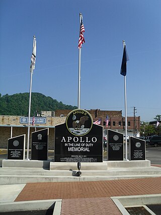
Apollo is a borough in Armstrong County, Pennsylvania, United States, 35 miles (56 km) northeast of Pittsburgh in a former coal-mining region. Apollo was settled in 1790, laid out in 1816, and incorporated as a borough in 1848. The population was 1,615 at the 2020 United States Census

<span class="mw-page-title-main">Leechburg, Pennsylvania</span> Borough in Pennsylvania, United States

Leechburg is a borough in southern Armstrong County in the U.S. state of Pennsylvania, 35 miles (56 km) northeast of Pittsburgh. A population of 2,149 residents live within the borough limits as of the 2020 census, according to United States Census Bureau. Leechburg was founded by David Leech, for whom it was named, and was incorporated as a borough in 1850.

<span class="mw-page-title-main">Connellsville, Pennsylvania</span> City in Pennsylvania, United States

Connellsville is a city in Fayette County, Pennsylvania, United States, 36 miles (58 km) southeast of Pittsburgh and 50 miles (80 km) away via the Youghiogheny River, a tributary of the Monongahela River. It is part of the Pittsburgh metropolitan area. The population was 7,031 at the 2020 census.

<span class="mw-page-title-main">Plumville, Pennsylvania</span> Borough in Pennsylvania, United States

Plumville is a borough in Indiana County, Pennsylvania, United States. The population was 257 at the 2020 census.

<span class="mw-page-title-main">Calumet-Norvelt, Pennsylvania</span> Unincorporated community in Pennsylvania, United States

Calumet-Norvelt was a census-designated place (CDP) in Westmoreland County, Pennsylvania, United States. The community was divided into the two separate communities of Calumet and Norvelt for the 2010 census. Although the US Census treats Calumet and Norvelt as a single community, they are in reality two very different communities, each reflecting a different chapter in how the Great Depression affected rural Pennsylvanians. Calumet was a typical "patch town", built by a single company to house its miners as cheaply as possible. The closing of the Calumet mine during the Great Depression caused enormous hardship in an era when unemployment compensation and welfare payments were non-existent. On the other hand, Norvelt was created during the depression by the US federal government as a model community, intended to increase the standard of living of laid-off coal miners.

<span class="mw-page-title-main">Crabtree, Pennsylvania</span> CDP in Pennsylvania, United States

Crabtree is a census-designated place (CDP) and former coal town in Salem Township, Westmoreland County, Pennsylvania, United States. The population was 277 at the 2010 census. It has its own post office, with postal code 15624.

<span class="mw-page-title-main">Derry, Pennsylvania</span> Borough in Pennsylvania, United States

Derry is a borough in Westmoreland County in Pennsylvania, 45 miles (72 km) east of Pittsburgh. The Borough of Derry, consisting of the town area, should not be confused with Derry Township, which is a separate municipality surrounding the borough. The population was 2,637 at the 2020 census.

<span class="mw-page-title-main">Export, Pennsylvania</span> Borough in Pennsylvania, United States

Export is a borough in Westmoreland County, Pennsylvania, United States, surrounded entirely by the municipality of Murrysville. The population was 893 at the 2020 census.

<span class="mw-page-title-main">Greensburg, Pennsylvania</span> City in Pennsylvania, United States

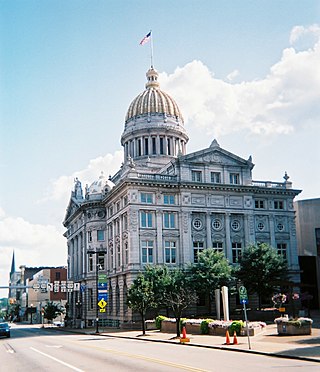
Greensburg is a city in and the county seat of Westmoreland County, Pennsylvania, United States. The population was 14,976 at the 2020 census. Located 30 miles (48 km) southeast of Pittsburgh, Greensburg is a part of the Pittsburgh metropolitan area. The city lies within the Laurel Highlands and the ecoregion of the Western Allegheny Plateau. The city is named after Nathanael Greene, a major general of the Continental Army in the American Revolutionary War.

<span class="mw-page-title-main">Hempfield Township, Westmoreland County, Pennsylvania</span> Township in Pennsylvania, United States

Hempfield Township is a township in Westmoreland County, Pennsylvania, United States. The population was 41,585 at the 2020 census, making it the largest suburb in the Pittsburgh Metropolitan Area by population. Its name is derived from Hempfield in Lancaster County, which was formed in 1729 and is named after the hemp fields in the area.

<span class="mw-page-title-main">Irwin, Pennsylvania</span> Borough in Pennsylvania, United States

Irwin is a borough in Westmoreland County, Pennsylvania, 22 miles (35 km) southeast of Pittsburgh. Some of the most extensive bituminous coal deposits in the commonwealth are located here. In the past, iron foundries, flour mills, car shops, facing and planing mills, electricals goods, and mirror factories provided employment to the residents. In 1900, the population numbered 2,452; it increased to 2,886 in 1910. The population was 3,973 at the 2010 census.

<span class="mw-page-title-main">Mount Pleasant, Pennsylvania</span> Borough in Pennsylvania, United States

Mount Pleasant is a borough in Westmoreland County, Pennsylvania, United States. It stands 45 miles (72 km) southeast of Pittsburgh. As of the 2020 census, the borough's population was 4,245.

<span class="mw-page-title-main">New Stanton, Pennsylvania</span> Borough in Pennsylvania, United States

New Stanton is a borough in Westmoreland County, Pennsylvania, United States. The population was 2,339 at the 2020 census. New Stanton is often used as a control city in western parts of Pennsylvania, as I-70 joins the Pennsylvania Turnpike (I-76) eastbound towards Breezewood in New Stanton, and is a free highway westbound.

<span class="mw-page-title-main">Scottdale, Pennsylvania</span> Borough in Pennsylvania, United States

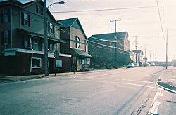
Scottdale is a borough in Westmoreland County, Pennsylvania, United States, 32 miles (51 km) southeast of Pittsburgh.

<span class="mw-page-title-main">Smithton, Pennsylvania</span> Borough in Pennsylvania, United States

Smithton is a borough in Westmoreland County, Pennsylvania, United States. The population was 399 at the 2010 census. As of 2018, the population was listed at 378. Smithton has its own post office, with zip code 15479, and is serviced by Yough School District.

<span class="mw-page-title-main">Southwest Greensburg, Pennsylvania</span> Borough in Pennsylvania, United States

Southwest Greensburg is a borough in Westmoreland County, Pennsylvania, United States. The population was 2,155 as of the 2010 census.

<span class="mw-page-title-main">Unity Township, Pennsylvania</span> Township in Pennsylvania, United States

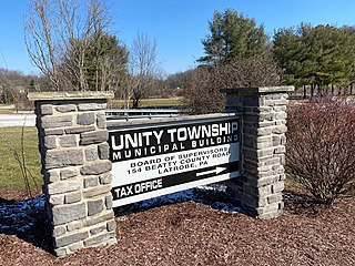
Unity Township is a township in Westmoreland County, Pennsylvania, United States. The population was 21,724 at the 2020 census, a decline of approximately 4% compared to the 2010 census.

<span class="mw-page-title-main">Youngstown, Pennsylvania</span> Borough in Pennsylvania, United States

Youngstown is a borough in Westmoreland County, Pennsylvania, United States. Youngstown was incorporated on April 2, 1831. The population was 326 at the 2010 census. The borough has its own post office, with zip code 15696, established on April 1, 1813.

<span class="mw-page-title-main">Youngwood, Pennsylvania</span> Borough in Pennsylvania, United States

Youngwood is a borough in Westmoreland County, Pennsylvania, United States.

References

  1. "2019 U.S. Gazetteer Files". United States Census Bureau. Retrieved July 28, 2020.
  2. 1 2 "Population and Housing Unit Estimates". United States Census Bureau. May 24, 2020. Retrieved May 27, 2020.
  3. Miller, Jim (2003). Greensburg PA: The Other Side of the Tracks: Industrial History/Archaeology of the Greensburg Area: An Interpretation of Greensburg's Industrial Past by Jim Miller. Greensburg, Pennsylvania: Privately published by author. p. 175.
  4. Miller, Jim (2003). Greensburg PA: The Other Side of the Tracks: Industrial History/Archaeology of the Greensburg Area: An Interpretation of Greensburg's Industrial Past by Jim Miller. Greensburg, Pennsylvania: Privately published by author. p. 176.
  5. 1 2 3 McDonough, Judith (Summer 1997). "Worker solidarity, judicial oppression, and police repression in the Westmoreland County, Pennsylvania Coal Miner's Strike, 1910-11". Pennsylvania History. 64 (3): 384–406. JSTOR   27774000. Some sources spell the Chief's name as Ketz, but Keltz is correct.
  6. Miller, Jim (2003). Greensburg PA: The Other Side of the Tracks: Industrial History/Archaeology of the Greensburg Area: An Interpretation of Greensburg's Industrial Past by Jim Miller. Greensburg, Pennsylvania: Privately published by author. p. 180.
  7. Smith, Rachel E. (2007). Greensburg (Postcard History Series). Charleston, SC: Arcadia Publishing. p. 100. ISBN   978-0-7385-5480-8.
  8. "US Gazetteer files: 2010, 2000, and 1990". United States Census Bureau. February 12, 2011. Retrieved April 23, 2011.
  9. "Census of Population and Housing". U.S. Census Bureau. Retrieved December 11, 2013.
  10. 1 2 "U.S. Census website". United States Census Bureau . Retrieved January 31, 2008.
  11. "Incorporated Places and Minor Civil Divisions Datasets: Subcounty Resident Population Estimates: April 1, 2010 to July 1, 2012". Population Estimates. U.S. Census Bureau. Archived from the original on June 11, 2013. Retrieved December 11, 2013.