History
"Dirnaseer" was the name of an extensive sheep run operated by Henry Scott & Sons, later Scott Bros. (Murray and Percy) from 1906 [3] to around November 1919, [4] when they sold it to the State Government for subdivision into soldier-settler blocks.
The property "Dirnaseer" adjoined part of George Main's property "Retreat"; George and his brother Hugh Main, who owned a separate part of "Retreat" were well disposed towards the soldier-settlers, and were instrumental in getting the Soldiers' Hall started. [5] Dirnaseer Hall was opened on 15 October 1924 with a dance floor area 40 by 30 feet (12.2 m × 9.1 m), plus kitchen and ladies' change room. [6]
In 1940 George Main's daughter Mary married Clive Caldwell at the Dirnaseer chapel. The reception was held the previous day at the Albion Hotel, Cootamundra, to cater for their large number of friends, far more than could be accommodated in a tiny country chapel.
Information is needed as to what extent "Dirnaseer" station is congruent with the locality.

Gundagai is a town in New South Wales, Australia. Although a small town, Gundagai is a popular topic for writers and has become a representative icon of a typical Australian country town. Located along the Murrumbidgee River and Muniong, Honeysuckle, Kimo, Mooney Mooney, Murrumbidgee and Tumut mountain ranges, Gundagai is 390 kilometres (240 mi) south-west of Sydney. Until 2016, Gundagai was the administrative centre of Gundagai Shire local government area. In the 2021 census, the population of Gundagai was 2,057.

Cootamundra, nicknamed Coota, is a town in the South West Slopes region of New South Wales, Australia and within the Riverina. It is within the Cootamundra-Gundagai Regional Council. At the 2016 Census, Cootamundra had a population of 6,782. It is located on the Olympic Highway at the point where it crosses the Muttama Creek, between Junee and Cowra. Its railway station is on the Main Southern line, part of the Melbourne-to-Sydney line.

Edward George Dyson was an Australian journalist, poet, playwright and short story writer. He was the elder brother of illustrators Will Dyson (1880–1938) and Ambrose Dyson (1876–1913), with three sisters also of artistic and literary praise.
The Hurstville City Council was a local government area in the St George and southern region of Sydney, New South Wales, Australia. The city seat of Hurstville is located 17 kilometres (11 mi) south–west of Sydney and west of Botany Bay. Hurstville was incorporated as a municipality in 1887, declared a city in 1988, and abolished in 2016, forming with Kogarah City Council the new Georges River Council.
The Progressive Party was an Australian political party, active in New South Wales state politics. The question of tariff policy which, had created and divided the Free Trade Party and Protectionist Party in New South Wales in the 1890s, became a federal issue at the time of federation. Deprived of their main ideological difference, the two parties were recreated as the Liberal Reform Party aligned with the federal Free Trade Party and the Progressive Party aligned with the federal Protectionist Party.

Gundagai Shire was a local government area in the Riverina region of New South Wales, Australia. On 12 May 2016, Gundagai Shire was abolished and merged with the neighbouring Cootamundra Shire to establish Cootamundra-Gundagai Regional Council.
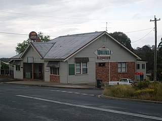
Wolumla is an historical locality in New South Wales, Australia located 234km south of Canberra, between Bega and Merimbula. Wolumla is located on the hilly coastal hinterland near the headwaters of Frogs Hollow Creek, and has been predominantly cleared for beef, dairy and sheep grazing. At the 2016 census, Wolumla had a population of 703.
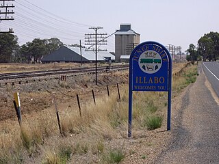
Illabo is a locality in the South West Slopes part of the Riverina in New South Wales, Australia. It is situated about 13 kilometres (8 mi) southwest of Bethungra and 16 kilometres (10 mi) northeast of Junee. At the 2016 census, Illabo had a population of 144.

Jugiong is a locality and town on the banks of the Murrumbidgee River near its confluence with Jugiong Creek. in the Hilltops Council Local Government area, New South Wales, Australia. It is situated just off the Hume Highway, by road, about 30 kilometres southwest from Bookham and 40 kilometres northeast from Gundagai.

The Shire of Erina was a local government area covering the majority of the Central Coast region of New South Wales, Australia. The shire was proclaimed on 7 March 1906 as a result of the passing of the Local Government (Shires) Act 1905 and covered most of the Central Coast region with the exception of the Town of Gosford, which had been incorporated in 1886.
Hugh Main was an Australian politician. He was a member of the New South Wales Legislative Assembly from 1920 until 1938, representing the electorates of Cootamundra (1920–1927) and Temora (1927–1938). Initially elected as a Progressive, he was a member of the party's rural "True Blues" faction that by 1927 had evolved into the Country Party.
Yancannia Station most commonly known as Yancannia is a pastoral lease that operates as a sheep station in north west New South Wales.

The Farmer & Settler was an English-language broadsheet newspaper published in Sydney, Australia, between 1906 and 1957. It was primarily published weekly.
The Cootamundra Herald is a former printed bi-weekly newspaper now existing only on-line and containing little or no news of direct relevance to the community of Cootamundra, New South Wales, Australia. The Herald website carries syndicated non-local copy with occasional government media releases referring to local issues. Following the purchase of the masthead in 2019 by Australian Community Media, the Herald office which had existed for 144 years in the main street was closed and local staff were forced to work part-time from home. The staff resigned or were eventually sacked, and there are now no local Herald employees generating content related to the town.
John Louis Treflé was a farmer, newspaper proprietor and politician in New South Wales, Australia.
The Border Police of New South Wales was a frontier policing body introduced by the colonial government of New South Wales with the passing of the Crown Lands Unauthorised Occupation Act 1839.

George Main was an Australian pastoralist and horse breeder, chairman of the Australian Jockey Club (AJC)(later Australian Turf Club) from 1937 to 1945.
Jindalee Shire was a local government area in the Riverina region of New South Wales, Australia.
The Salt Clay Creek railway disaster was one of Australia's first railway accidents involving multiple fatalities. It occurred on the evening of 25 January 1885, when a mail train from Albury to Sydney failed to negotiate a flooded creek, around 5 km from Cootamundra. Seven people were killed and dozens seriously injured.
The Farmers' and Settlers' Association of New South Wales was an umbrella organisation of farmers' and selectors' associations in New South Wales, founded in 1893.
