The International Garden Festival was a garden festival recognised by the International Association of Horticultural producers (AIPH) and the Bureau International des Expositions (BIE), which was held in Liverpool, England from 2 May to 14 October 1984. It was the first such event held in Britain, and became the model for several others held during the 1980s and early 1990s. The aim was to revitalise tourism and the city of Liverpool which had suffered cutbacks, and the idea came from Conservative Environment Minister Michael Heseltine. The festival was hugely popular, attracting 3,380,000 visitors.

Standish is a village in the Metropolitan Borough of Wigan, Greater Manchester, England. Historically in Lancashire, it is on the A49 road between Chorley and Wigan, near Junction 27 of the M6 motorway. The population of the town was 13,278 in the 2011 census.

Bowning is a small town in the Southern Tablelands, 14 kilometres (8.7 mi) west of Yass on the Hume Highway in Yass Valley Shire. Bowning is an aboriginal word meaning 'big hill'. At the 2016 census, Bowning and the surrounding area had a population of 573.

Bethungra is a locality in Junee Shire in the South West Slopes region of New South Wales, Australia situated on the Olympic Highway about 13 kilometres northeast of Illabo and 24 kilometres southwest of Cootamundra.
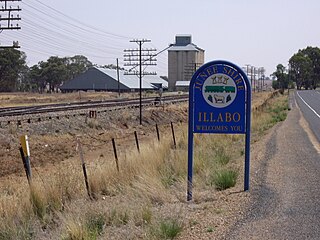
Illabo is a locality in the South West Slopes part of the Riverina in New South Wales, Australia. It is situated about 13 kilometres (8 mi) southwest of Bethungra and 16 kilometres (10 mi) northeast of Junee. At the 2016 census, Illabo had a population of 144.

Frampton is a village on the Sydney to Melbourne rail line in the north east part of the Riverina about 14 kilometres south west of Cootamundra and eight kilometres north east of Bethungra.

Muttama is a rural community in the central east part of the Riverina. It is situated by road, about 24 kilometres south of Cootamundra and 17 kilometres north of Coolac.

Kamarah, is a village community in the central north part of the Riverina. It is situated by road, about 11 kilometres west of Ardlethan and 12 kilometres east of Moombooldool. At the 2006 census, Kamarah had a population of 130 people.

Brushwood is a rural community in the central east part of the Riverina region of New South Wales, Australia. It is situated by road about 6 kilometres (3.7 mi) east of Ganmain and 8 kilometres (5.0 mi) west of Coolamon.

Combaning is a rural community in the north east part of the Riverina. It is situated by road, about 3 kilometres west of Springdale and 13 kilometres east of Temora. At the 2006 census, Combaning had a population of 214 people.

Widgiewa is a small community in the central part of the Riverina in New South Wales, Australia.
Westby is a rural community in the central east part of the Riverina. It is situated by road, about 9 kilometres south east of Pulletop and 18 kilometres north of Little Billabong.

Springdale is a village community in the central north part of the Riverina region of the Australian state of New South Wales. It is situated by road, about 3 kilometres east of Combaning and 23 kilometres north west of Stockinbingal. At the 2016 census, it had a population of 150.
Goorawin is a rural locality and the site of a discontinued railway station and siding in the central northern part of the Riverina. It is situated by rail, about 7 kilometres south of Langtree and 12 kilometres north of Merriwagga.
Niemur is a historic village community in the central west part of the Riverina and the site of a railway station. It is situated about 24 kilometres south east of Moulamein and 27 kilometres north west of Burraboi.

Bell is a small rural and residential village in the Blue Mountains region of New South Wales, Australia. It is the north-westernmost village in the City of Blue Mountains, located approximately 125 kilometres (78 mi) west of Sydney central business district by road or 137 kilometres (85 mi) by rail, approximately 20 kilometres (12 mi) east of Lithgow and 10 kilometres (6.2 mi) north of Mount Victoria. It is a locality on the junction of the Bells Line of Road, Chifley Road and the Darling Causeway, with an elevation of approximately 1,100 metres (3,600 ft) AHD .

Lake Bathurst is a shallow lake located 27 kilometres (17 mi) south-east of Goulburn, New South Wales in Australia. It is also the name of a nearby locality in the Goulburn Mulwaree Council.

Cullerin is a small township in the Southern Tablelands of New South Wales, Australia. It is on the Old Hume Highway and Main South railway line in Upper Lachlan Shire. The Cullerin railway station opened in 1880 and closed in 1973. At the 2016 census, it had a population of 38.

Langtree School is a coeducational secondary school located in the village of Woodcote in South Oxfordshire, England. It became a DfES Specialist Performing Arts College in 2006.

Dunmore is a largely rural suburb of Shellharbour City in New South Wales, Australia. Dunmore is bisected north to south by the South Coast railway line and the Princes Highway.
