
Yanco is a village with a population of 505 in Leeton Shire in south western New South Wales, Australia. Yanco is a Wiradjuri aboriginal language word meaning the sound of running water. Yanco is located 3 kilometres (1.9 mi) from Leeton along Irrigation Way. Yanco is home to the Powerhouse Museum, McCaughey Park, Murrumbidgee Rural Studies Centre and Yanco Agricultural High School.

Mount Victoria is a small township in the Blue Mountains of New South Wales, Australia. Mount Victoria is geographically the western most village and suburb of Greater Sydney on the great western highway in the City of Blue Mountains, located about 120 kilometres (75 mi) west-northwest by road from the Sydney central business district and at an altitude of about 1,052 metres (3,451 ft) AHD . The settlement had a population of 823 people at the 2011 Census.

Leeton Shire is a local government area in the Riverina region of New South Wales, Australia. The Shire is located adjacent to the Murrumbidgee River and falls within the Murrumbidgee Irrigation Area.
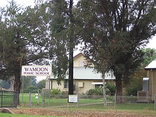
Wamoon is a village in Leeton Shire in the Riverina region of New South Wales, Australia. Wamoon is located 8.8 kilometres (5.5 mi) from Leeton along the Irrigation Way to the Leeton CBD and Henry Lawson Drive to the Leeton suburb of Wattle Hill. Wamoon provides a village of homes to the farmers of northern Leeton and there is a small primary school known as Wamoon Public School.

Moulamein is a small town in New South Wales, Australia, in the Murray River Council local government area. At the 2016 census, Moulamein had a population of 484. Moulamein is the oldest town in the Riverina.

Bethungra is a locality in Junee Shire in the South West Slopes region of New South Wales, Australia situated on the Olympic Highway about 13 kilometres northeast of Illabo and 24 kilometres southwest of Cootamundra.

Ganmain is a town in the Riverina region of New South Wales, Australia. Ganmain is located around 55 kilometres (34 mi) north west of Wagga Wagga, and 50 kilometres (31 mi) east of Narrandera. Ganmain is in the Coolamon Shire local government area and had a population at the 2016 census of 779.

Downside is a farming community in the central east part of the Riverina and situated about 15 kilometres north west from Wagga Wagga and 24 kilometres south east from Coolamon.

Eurongilly is a locality in the central part of the Riverina and situated about 19 kilometres north west of Nangus and 21 kilometres south east of Junee.

Harefield is a locality in New South Wales, Australia. It in the central east part of the Riverina and situated about 11 kilometres south of Junee and 35 kilometres north by road from Wagga Wagga.
Burrinjuck is a village community in the far eastern part of the Riverina. It is situated by road, about 15 kilometres southwest from Woolgarlo and 28 kilometres south from Bookham. The name of the town is derived from an Aboriginal word meaning 'mountain with a rugged top'. At the 2016 census, the Burrinjuck area had a population of 19.

Junee Reefs is a locality in the south east part of the Riverina, Australia. It is situated by road, about 19 kilometres north of Old Junee and 19 kilometres south of Sebastopol. At the 2006 census, Junee Reefs had a population of 136 people.

Darbalara is a rural community on the east bank of the junction of the Murrumbidgee River and Tumut River in the Riverina. It is situated by road, about 25 kilometres north east of Gundagai and 25 kilometres south of Coolac.

Springdale is a village community in the central north part of the Riverina region of the Australian state of New South Wales. It is situated by road, about 3 kilometres east of Combaning and 23 kilometres north west of Stockinbingal. At the 2016 census, it had a population of 150.

Corobimilla is a village locality in the central east part of the Riverina. It is situated by road, about 12 kilometres northeast of Morundah and 20 kilometres south west of Narrandera.

Dorrigo, a small town on the Waterfall Way, is located on the Northern Tablelands, in northern New South Wales, Australia. The town is part of Bellingen local government area.

Postcodes in Australia are used to more efficiently sort and route mail within the Australian postal system. Postcodes in Australia have four digits and are placed at the end of the Australian address, before the country. Postcodes were introduced in Australia in 1967 by the Postmaster-General's Department and are now managed by Australia Post, Australia's national postal service. Postcodes are published in booklets available from post offices or online from the Australia Post website.
Manning Point is a small village located at the mouth of the Manning River in New South Wales, Australia. Lying on Mitchells Island, it lies opposite the town of Harrington. It is 26 kilometres (16 mi) east of Taree on the Mid North Coast. At the 2006 census, Manning Point had a population of 228.

The Billabong Creek, a partly perennial stream of the Murray River catchment within the Murray-Darling basin, is located in the Riverina region of New South Wales, Australia.
