Redfern is an inner southern suburb of Sydney located 3 kilometres (1.9 mi) south of the Sydney central business district and is part of the local government area of the City of Sydney. Strawberry Hills is a locality on the border with Surry Hills. The area experienced the process of gentrification and is subject to extensive redevelopment plans by the state government, to increase the population and reduce the concentration of poverty in the suburb and neighbouring Waterloo.
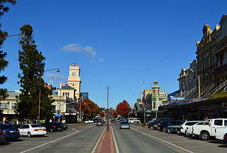
Goulburn is a regional city in the Southern Tablelands of New South Wales, Australia, approximately 195 kilometres (121 mi) south-west of Sydney and 90 kilometres (56 mi) north-east of Canberra. It was proclaimed as Australia's first inland city through letters patent by Queen Victoria in 1863. Goulburn had a population of 24,565 as of the 2021 census. Goulburn is the seat of Goulburn Mulwaree Council.

Wentworth is a small border town in the far south west of the state of New South Wales, Australia. It lies at the confluence of Australia's two most important rivers, the Darling and the Murray, the latter forming the border with the state of Victoria to the south. The border with the state of South Australia lies approximately 100 kilometres (62 mi) to the west. The town of Wentworth is in the local government area of the same name.

Singleton is a town on the banks of the Hunter River in New South Wales, Australia. Singleton is 202km (89 mi) north-north-west of Sydney, and 70 km (43 mi) north-west of Newcastle. At June 2018, Singleton had an urban population of 16,346.
Randwick is a suburb in the Eastern Suburbs of Sydney, in the state of New South Wales, Australia. Randwick is located 6 kilometres south-east of the Sydney central business district and is the administrative centre for the local government area of the City of Randwick. The postcode is 2031.

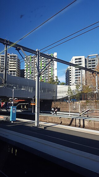
North Sydney is a suburb and major commercial district on the Lower North Shore of Sydney, New South Wales, Australia. It is located three kilometres north of the Sydney central business district and is the administrative centre for the local government area of North Sydney Council.

Burwood is a suburb in the Inner West of Sydney, in the state of New South Wales, Australia. It is 10 kilometres (6.2 mi) west of the Sydney central business district and is the administrative centre for the local government area of Municipality of Burwood.

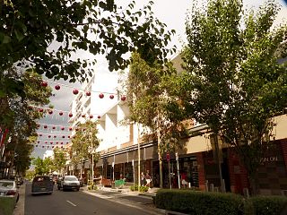
Rozelle is a suburb in the inner west of Sydney, in the state of New South Wales, Australia. It is located 4 kilometres west of the Sydney central business district, in the local government area of the Inner West Council.

Emu Plains is a suburb of Sydney in the state of New South Wales, Australia. It is 58 kilometres west of the Sydney central business district, in the local government area of the City of Penrith and is part of the Greater Western Sydney region.
Berrima is a historic village in the Southern Highlands of New South Wales, Australia, in Wingecarribee Shire. The village, once a major town, is located on the Old Hume Highway between Sydney and Canberra. It was previously known officially as the Town of Berrima. It is close to the three major towns of the Southern Highlands: Mittagong, Bowral and Moss Vale.
Rouse Hill is a suburb of Sydney, in the state of New South Wales, Australia. Rouse Hill is located in the Hills District, 43 kilometres north-west of the Sydney central business district and 19 kilometres north-west of the Parramatta central business district. It is in the local government areas of The Hills Shire and City of Blacktown. Rouse Hill Town Centre is at the heart of the suburb, which contains a busy Town Square.

Moss Vale is a town in the Southern Highlands of New South Wales, Australia, in the Wingecarribee Shire. It is located on the Illawarra Highway, which connects to Wollongong and the Illawarra coast via Macquarie Pass.

Harris Park is a suburb of Greater Western Sydney, in the state of New South Wales, Australia. Harris Park is located 19 kilometres west of the Sydney central business district in the local government area of the City of Parramatta and is part of the Greater Western Sydney region. Harris Park has a plurality of Indian and Hindu population, both making up the largest ethnic and religious group.

Grong Grong is a small town that is located in the Riverina region of New South Wales, Australia. The town is situated on the Newell Highway, 23 kilometres (14 mi) east of Narrandera in the Shire of Narrandera.

Sutton Forest is a small village in the Southern Highlands, New South Wales, Australia in Wingecarribee Shire. It is located 5 km southwest of Moss Vale on the Illawarra Highway. Sutton Forest was originally granted, then owned by Navy Chief officer, Captain John Nicholson who recently immigrated from Scotland to Australia. This privately owned estate was originally 700 acres, this is where John Nicholson lived and died.

Tamworth Regional Council is a local government area in the New England region of New South Wales, Australia. The area under administration is located adjacent to the New England Highway and the Main North railway line. It was established in March 2004 through the amalgamation of the former City of Tamworth with surrounding shires of Barraba, Manilla, Nundle and Parry.

Wakool is a town in the western Murray region of New South Wales, Australia. Wakool is in the Murray River Council local government area, 791 kilometres (492 mi) south west of the state capital, Sydney and 336 kilometres (209 mi) north-west of Melbourne. At the 2016 census, Wakool had a population of 297.

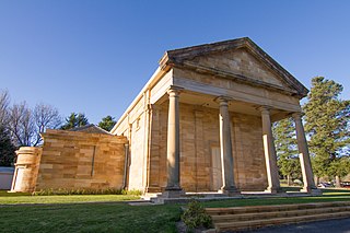
The National Shrine and Church of Our Lady of the Sacred Heart is a Roman Catholic church in Randwick in the South-Eastern Suburbs of Sydney, New South Wales, Australia. It is heritage-listed.
Our Lady of Pompeii Church or Our Lady of Pompei Church may refer to:

Our Lady of Pompeii Roman Catholic Church is a heritage-listed Catholic church at Edon Street, Yoogali, City of Griffith, New South Wales, Australia. It was designed by Antonio Ceccato and built from 1939 to 1940 by Ceccato and members of the Italian community. It is also known as Our Lady of the Holy Rosary of Pompeii and St Mary's Church. It was added to the New South Wales State Heritage Register on 15 December 2006.

