Related Research Articles

Eastland County is a county located in central West Texas. As of the 2020 census, its population was 17,725. The county seat is Eastland. The county was founded in 1858 and later organized in 1873. It is named for William Mosby Eastland, a soldier during the Texas Revolution and the only officer to die as a result of the "Black Bean executions" of the Mier Expedition.

Lanark is a city in Carroll County, Illinois, United States. The population was 1,504 at the 2020 census, down from 1,584 at the 2010 census. The city was named after Lanark, in Scotland.

Harper Woods is a city in Wayne County in the U.S. state of Michigan. An inner ring suburb of Detroit, Harper Woods borders Detroit to the north and east, roughly 9 miles (14.5 km) northeast of downtown Detroit. As of the 2020 census, the city had a population of 15,492.
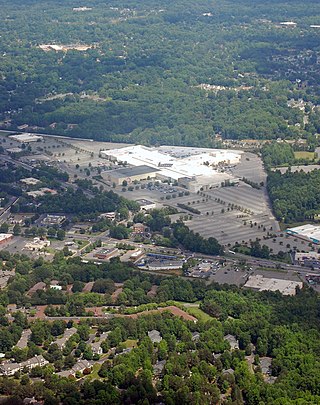
Eastland is a neighborhood in Charlotte, North Carolina, USA. The area is named after the former eponymous mall, that was demolished in the 2014. Eastland is almost seven and a half miles from Uptown, Charlotte.
Bryan Station is a neighborhood in Northeast Lexington, Kentucky, United States. It is named after the nearby pioneer settlement by the same name located just 2 miles (3 km) outside the current edge of the city.
Joyland is a neighborhood in Northeast Lexington, Kentucky, United States. Its boundaries are I-75/ I-64 to the south, Paris Pike to the east, Russell Cave Road to the west, and the Lexington Urban Growth Boundary to the north. Joyland is the only north Lexington neighborhood to be located entirely north of I-75.
Highland Parks is a neighborhood in northwest Lexington, Kentucky, United States. It is a new subdivision started in the mid-2000s, located between the older Highlands and Oakwood neighborhoods. It is located south of Birch Drive and north of Boxwood Drive. It is bounded by Georgetown Road to the west and Oakwood Park to the east.
Spindletop is a rural neighborhood north of Lexington, Kentucky, United States. Its boundaries are I-75 to the west and Berea Road to the south and east. It is located just south of the Kentucky Horse Park. It is named for Spindletop hall, a historic mansion once owned by Miles Franklin Yount, which is located within the neighborhood.

Northside is a neighborhood in northern Lexington, Kentucky, United States. Its boundaries are Loudon Avenue to the north and east, Short Street, Midland Avenue, and Winchester Road to the south, and Newtown Pike to the west.
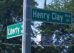
Liberty Heights is a neighborhood in southeastern Lexington, Kentucky, United States. Its boundaries are Winchester Road to the north, New Circle Road to the east, and R. J. Corman railroad tracks to the west and south.
Gainesway is a neighborhood in southeastern Lexington, Kentucky, United States. Its boundaries are New Circle Road to the north, Tates Creek Road to the west, Armstrong Mill Road to the south, and a combination of Pimlico Parkway and Bold Bidder Drive to the east.
Meadowthorpe is a neighborhood in western Lexington, Kentucky, United States. Its boundaries are Leestown Road to the south, New Circle Road to the west, and Norfolk Southern railroad tracks to the north and east. Since 2000, areas south of Leestown Road have seen residential and commercial development in Townley Center. This area is not a part of the Meadowthorpe neighborhood. Schools in the area are Meadowthorpe Elementary and Leestown Middle School.
Saddle Club is a neighborhood in northern Lexington, Kentucky, United States. Its boundaries are New Circle Road to the west and north, Versailles Road to the south, and Viley Road to the east.
Radcliffe is a neighborhood in northern Lexington, Kentucky, United States. It is alternatively called Marlboro. Its boundaries are Dover Road to the south, Paris Pike to the east, Russell Cave Road to the west, and I-75/ I-64 to the north.
Elkhorn Park is a neighborhood in northern Lexington, Kentucky, United States. Its boundaries are Dover Road to the north, North Broadway to the east, New Circle Road to the south, and Russell Cave Road to the west.

Calumet is a neighborhood in northern Lexington, Kentucky, United States. Its boundaries are Viley Road to the west, Versailles Road to the south, New Circle Road to the north, and Wolf Run Creek to the east.

Masterson Station is a neighborhood in northwestern Lexington, Kentucky, United States. Its boundaries are Masterson Station Park on the west, Leestown Road to the south, Greendale Road to the east, and Spurr Road to the north.
Highlands is a neighborhood in northwestern Lexington, Kentucky, United States. Its boundaries are Georgetown Road to the west, Oakwood Park to the east, and Citation Boulevard to the east. There are plans to develop a vacant field north of Highlands, it is unclear whether it will become part of Highlands or be a separate neighborhood.
Hartland is a neighborhood in southeastern Lexington, Kentucky, United States. Its boundaries are Tates Creek Road to the west, Armstrong Mill Road to the east, the Lexington urban growth boundary to the south, and Kenesaw Drive to the north.
Idle Hour is a neighborhood in southeastern Lexington, Kentucky, United States. Its boundaries are Idle Hour Country Club to the north, CSX railroad tracks to the east, New Circle Road to the south, and Richmond Road to the west.
References
- 1 2 Eastland Neighborhood Profile city-data.com. Retrieved on 2010-01-01


| | This Fayette County, Kentucky state location article is a stub. You can help Wikipedia by expanding it. |