Related Research Articles

Lexington is the second-most-populous city in the Commonwealth of Kentucky, and the 60th-most populous city in the United States. It is the county seat of Fayette County. By land area, it is the country's 30th-largest city.
Fayette County is located in the central part of the U.S. state of Kentucky and is consolidated with the city of Lexington. As of the 2020 census, the population was 322,570, making it the second-most populous county in the commonwealth. Since 1974, its territory, population and government have been shared with Lexington. Fayette County is part of the Lexington-Fayette, KY Metropolitan Statistical Area.

New Circle Road, also known as Kentucky Route 4, is a Kentucky state highway that serves as an inner beltway around Lexington, which is part of the consolidated city-county government with Fayette County.

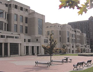
The Lexington History Center once housed several independent history museums in downtown Lexington, Kentucky. It was located in the former Fayette County Courthouse until 2012 when the city closed the building for renovation. Prior to the closing of the building, the Isaac Scott Hathaway Museum moved to a new location on Georgetown Street. The building has since been renovated into a multi-use commercial, tourist, office and event center.

Kentucky Route 1974, also known as Tates Creek Road, stretches from New Circle Road at its northern terminus and proceeds southeast towards Spears. It has become a popular commuting route from points south, especially with recent housing development south of Man o' War Boulevard that stretches to Kentucky Route 1980. KY 1974 was widened from two to four lanes south of Man o' War Boulevard to KY 1980 in the late 1990s. It becomes a rural two-lane road with very light traffic to its southern terminus with KY 169, which leads to the Valley View Ferry.
Man o' War Boulevard, named after the racehorse Man o' War, is an almost 17-mile (27 km) urban arterial, circling Lexington, Kentucky to its south. Its western terminus is at US 60 / Keeneland Boulevard at Keeneland Race Course's main entrance, from which the highway heads southeast, intersecting with US 68, US 27, and other roads. It then turns east and northeast, intersecting KY 1974, US 25/US 421, and I-75, before ending at US 60 at Brighton. The majority of the road is a four-lane divided highway with curbs and sidewalks maintained by the Lexington-Fayette Urban County Government, but the 1.429-mile (2.300 km) portion east of I-75 is maintained by the Kentucky Transportation Cabinet as Supplemental Road Kentucky Route 1425, and only carries two lanes.

Kentucky Route 1723 was a 1-mile-long (1.6 km) north–south state highway in Lexington. It was deleted in 2018.
Citation Boulevard, a four-lane divided highway, currently extends from just west of US 25 at the Norfolk Southern Railway to KY 922 in Lexington, Kentucky. Known as Phase I, it was completed in 2001 and included a bridge over Cane Run. Phase II extends southwest from the Norfolk Southern Railway to US 421 at Alexandria Drive and includes a span over the railroad. The highway west of Newtown Pike was constructed by the Kentucky Transportation Cabinet.

The Hunt–Morgan House, historically known as Hopemont, is a Federal style residence in Lexington, Kentucky built in 1814 by John Wesley Hunt, the first millionaire west of the Alleghenies. The house is included in the Gratz Park Historic District. The Alexander T. Hunt Civil War Museum is located on the second floor of the Hunt–Morgan House.
The following is a timeline of the history of Lexington, Kentucky, United States.

Douglass School in Lexington, Kentucky, US, was both a primary and secondary Fayette County Public Schools from 1929 to 1971. Douglass School operated solely for African American students. The building that once housed Douglass School, located at 465 Price Road, was listed on the National Register of Historic Places in Fayette County in 1998.
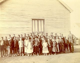
Cadentown School in Lexington, Kentucky was a primary public school for black children in the segregated Fayette County Public Schools from about 1879 to 1922. The building that originally housed Cadentown School, located at 705 Caden Lane, is no longer extant. However, the Rosenwald Fund School is listed on the National Register of Historic Places in Fayette County.

Kentucky Route 353 (KY 353) a 19.940-mile-long (32.090 km) state highway in the U.S. state of Kentucky. The highway connects Fayette, Bourbon, and Harrison counties with Lexington.

Kentucky Route 1973 is a 33.886-mile-long (54.534 km) north–south secondary state highway located in Fayette and Scott counties in east-central Kentucky. It traverses the eastern and northern suburbs of Lexington and southern Scott County.

Kentucky Route 859 is a 3.184-mile-long (5.124 km), rural, secondary state highway located entirely in Fayette County in east-central Kentucky. It is locally known as Haley Road, and mainly traverses the eastern portions of the county.

Kentucky Route 1928 was a state highway in the city of Lexington in Fayette County, Kentucky. The highway ran 0.170 miles (0.274 km) along Jefferson Street from U.S. Route 60 east to US 25 and US 421.

Kentucky Route 1977 is an urban secondary state highway located entirely in northern Fayette County in East Central Kentucky. The 6.255 miles (10.066 km) mainly traverses the northwestern outskirts of Lexington.
Kentucky Route 1978, known locally as Greendale Road, is an urban secondary state highway located entirely in northern Fayette County in East Central Kentucky. The 2.242 miles (3.608 km) mainly traverses the northwestern outskirts of Lexington.
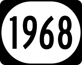
Kentucky Route 1968, known locally as Parkers Mill Road, is a secondary state highway located entirely in western Fayette County in East Central Kentucky. The 2.242 miles (3.608 km) mainly traverses the western suburbs of Lexington.
References
- ↑ Major Regional Employers Commerce Lexington. Retrieved 2018-07-29.
- ↑ Lexington-Fayette County Community Profile
- ↑ "Lexington Ky: Web Security and Front End Development". lexington-ky-web-security-design.blogspot.com.


