Woodward Heights, Lexington

Last updated

Woodward Heights Neighborhood Historic District
330 Madison Place, Lexington.jpg
A late nineteenth-century house typical of Woodward Heights
USA Kentucky location map.svg
Red pog.svg
LocationRoughly bounded by High, Merino, and Pine Sts., Lexington, Kentucky
Coordinates 38°3′0″N84°30′25″W / 38.05000°N 84.50694°W / 38.05000; -84.50694
Area24.5 acres (9.9 ha)
Builtca. 1818 through World War I
ArchitectMultiple
Architectural styleGreek Revival, Late Victorian, Federal
NRHP reference No. 80001525 [1]
Added to NRHPDecember 1, 1980

Woodward Heights is a neighborhood and historic district located immediately west of downtown Lexington, Kentucky. It is bounded by Maxwell Street and the Pleasant Green Hill neighborhood to the southwest, by the parking lot for Rupp Arena to the southeast, by the Lexington Convention Center property to the northeast, and by Herlihy, Cox, and High Streets to the north. [2]

Contents

The neighborhood includes one park, Woodward Heights Park, at 651 West High Street in the neighborhood's eastern corner. [3] The neighborhood has a land area of 0.049 square miles (0.13 km2), and as of 2009, a population of 292 people, a population density of 6,002 people per square mile, and a median household income of $34,571. [2] Like all of Lexington, the neighborhood is in the Fayette County Public Schools district. Neighborhood children attend Harrison Elementary School, Lexington Traditional Magnet School (middle school), and Lafayette High School. [4]

History

In 1980, the neighborhood was listed on the National Register of Historic Places, as Woodward Heights Neighborhood Historic District. [5]

The Historic Woodward Heights Neighborhood Association incorporated as a non-profit in 1989. [6]

Individually listed properties

In addition to being listed on the National Register of Historic Places as a district, several individual properties are or have been listed. Located near the center of Woodward Heights, Botherum, a private residence built in 1850, was listed in 1973. At the northeast side of the neighborhood, adjoining Woodward Heights Park, the Henry Watt House (also known as the Saunier House and the Watt-Saunier House) was listed in 1977. Built circa 1818, it was the second-oldest house in the area, and no longer stands.

Botherum

Botherum was built for Madison C. Johnson.

Henry Watt House

Henry Watt House
Watt-Saunier House.jpg
The Henry Watt House was built ca. 1818.
Location703 W. High St., Lexington, Kentucky
Coordinates 38°3′1″N84°30′17″W / 38.05028°N 84.50472°W / 38.05028; -84.50472
Area0.3 acres (0.12 ha)
Built1818
Part of Woodward Heights Neighborhood Historic District (ID80001525 [1] )
NRHP reference No. 77000615 [1]
Significant dates
Added to NRHPDecember 16, 1977
Designated CPDecember 1, 1980

Henry Watt House, aka Saunier House, aka Watt-Saunier House, stood at 703 West High Street in Lexington, Kentucky. House was built circa 1818 by an unknown architect, listed on the National Register of Historic Places in 1977, included as a contributing property in the 1980 listing of the Woodward Heights Neighborhood Historic District, and demolished in the 1990s following a fire.

Cassidy House

The Cassidy House at 816/820 W. High St., on the National Register of Historic Places, was built and occupied for the esteemed educator Massillon Alexander Cassidy. [7]

Related Research Articles

<span class="mw-page-title-main">Lexington, Kentucky</span> City in Kentucky, United States

Lexington is the second-most-populous city in the Commonwealth of Kentucky, and the 60th-most populous city in the United States. It is the county seat of Fayette County. By land area, it is the country's 30th-largest city.

<span class="mw-page-title-main">Ashland Park</span> United States historic place

Ashland Park is a historic early 20th century neighborhood in Lexington, Kentucky, United States. It was named after Ashland, the estate of Kentucky statesman Henry Clay which is located in the eastern portion of the neighborhood. The 600-acre (2.4 km2) development was designed by the famous landscape architecture firm the Olmsted Brothers of Massachusetts. The neighborhood belongs to the National Register of Historic Places.

<span class="mw-page-title-main">Clifton, Louisville</span> United States historic place

<span class="mw-page-title-main">Crescent Hill, Louisville</span> United States historic place

Crescent Hill is a neighborhood four miles (6 km) east of downtown Louisville, Kentucky USA. This area was originally called "Beargrass" because it sits on a ridge between two forks of Beargrass Creek. The boundaries of Crescent Hill are N Ewing Ave to the St. Matthews city limit by Brownsboro Road to Lexington Road. Frankfort Avenue generally bisects the neighborhood.

<span class="mw-page-title-main">National Register of Historic Places listings in Kentucky</span>

This is a list of properties and historic districts in Kentucky that are listed on the National Register of Historic Places. There are listings in all of Kentucky's 120 counties.

<span class="mw-page-title-main">Brush Park</span> United States historic place

The Brush Park Historic District is a neighborhood located in Detroit, Michigan. It is bounded by Mack Avenue on the north, Woodward Avenue on the west, Beaubien Street on the east, and the Fisher Freeway on the south. The Woodward East Historic District, a smaller historic district completely encompassed by the larger Brush Park neighborhood, is located on Alfred, Edmund, and Watson Streets, from Brush Street to John R. Street, and is recognized by the National Register of Historic Places.

<span class="mw-page-title-main">Hunt–Morgan House</span> Historic Federal style residence in Lexington, KY, US

The Hunt–Morgan House, historically known as Hopemont, is a Federal style residence in Lexington, Kentucky built in 1814 by John Wesley Hunt, the first millionaire west of the Alleghenies. The house is included in the Gratz Park Historic District. The Alexander T. Hunt Civil War Museum is located on the second floor of the Hunt–Morgan House.

<span class="mw-page-title-main">Gratz Park Historic District</span> Historic district in Lexington, Kentucky

Gratz Park is a neighborhood and historic district located just north of downtown Lexington, Kentucky. It was named after early Lexington businessman Benjamin Gratz whose home stands on the corner of Mill and New streets at the edge of Gratz Park. The Gratz Park Historic District consists of 16 contributing buildings including the Hunt-Morgan House, the Bodley-Bullock House, the original Carnegie Library in Lexington, and several other private residences. Gratz Park occupies a tract of land that was established in 1781 outside the original boundaries of Lexington.

<span class="mw-page-title-main">Virginia Park Historic District</span> Historic district in Michigan, United States

The Virginia Park Historic District is located on the north side of New Center, an area in Detroit, Michigan, along both sides of Virginia Park Street from Woodward Avenue to the John C. Lodge Freeway access road. The district was listed on the National Register of Historic Places in 1982.

<span class="mw-page-title-main">National Register of Historic Places listings in Detroit</span>

This is a list of the National Register of Historic Places listings in Detroit, Michigan.

<span class="mw-page-title-main">Highland Heights–Stevens' Subdivision Historic District</span> Historic district in Michigan, United States

Highland Heights–Stevens' Subdivision Historic District is a residential historic district located in Highland Park, Michigan along five east-west streets: Farrand Park, McLean Street, Colorado Street, Rhode Island Street, and Massachusetts Street, between Woodward Avenue on the west and Oakland Avenue on the east. The district was listed on the National Register of Historic Places in 1988.

<span class="mw-page-title-main">National Register of Historic Places listings in Fayette County, Kentucky</span>

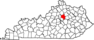
This is a list of the National Register of Historic Places listings in Fayette County, Kentucky.

<span class="mw-page-title-main">Liberty Heights, Lexington</span> Place in the United States

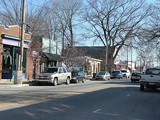
Liberty Heights is a neighborhood in southeastern Lexington, Kentucky, United States. Its boundaries are Winchester Road to the north, New Circle Road to the east, and R. J. Corman railroad tracks to the west and south.

<span class="mw-page-title-main">John McMurtry (architect)</span> American architect (1812-1890)

John McMurtry was a 19th-century American builder and architect who worked in Lexington, Kentucky designing a number of notable buildings, several of which are listed on the National Register of Historic Places.

<span class="mw-page-title-main">Botherum</span> Historic house in Kentucky, United States

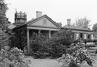
Botherum was built for Madison C. Johnson in 1850 or 1851 by John McMurtry, a well-known architect and builder based in Lexington. The house was intended, in part, as a shrine to Johnson's late wife Sally Ann, a sister of Cassius Marcellus Clay who died giving birth in 1828.

<span class="mw-page-title-main">Kilham & Hopkins</span>

Kilham & Hopkins was an architectural firm in Boston, Massachusetts formed in 1899 or 1900 by its founding members, Walter Harrington Kilham and James Cleveland Hopkins. The firm later became Kilham, Hopkins & Greeley after William Roger Greeley joined the firm in 1916, and Kilham Hopkins Greeley and Brodie after Walter S. (Steve) Brodie joined the firm in 1945.

The following is a timeline of the history of Lexington, Kentucky, United States.

<span class="mw-page-title-main">Cadentown School</span> School in Lexington, Kentucky

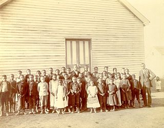
Cadentown School in Lexington, Kentucky was a primary public school for black children in the segregated Fayette County Public Schools from about 1879 to 1922. The building that originally housed Cadentown School, located at 705 Caden Lane, is no longer extant. However, the Rosenwald Fund School is listed on the National Register of Historic Places in Fayette County.

<span class="mw-page-title-main">Fayette National Bank Building</span> United States historic place

The Fayette National Bank Building, also known as the First National Bank Building or 21C Museum Hotel Lexington, is a historic 15-story high-rise in Lexington, Kentucky. The building was designed by the prominent architecture firm McKim, Mead & White and built by the George A. Fuller Company from 1913 to 1914. It was added to the National Register of Historic Places on February 27, 1980.

<span class="mw-page-title-main">Russell School (Lexington, Kentucky)</span> Public school active from 1895 to 2003

The Russell School (1895–2003) is a former public school located in the Northside neighborhood of Lexington, Kentucky. From 1895 until roughly the mid-1960s, the school was segregated and served African American students.

References

  1. 1 2 3 "National Register Information System". National Register of Historic Places . National Park Service. July 9, 2010.
  2. 1 2 Woodward Heights neighborhood in Lexington, Kentucky (KY), 40508 detailed profile, City-Data.com, retrieved September 2, 2011
  3. Woodward Heights Park, Lexington, Kentucky , retrieved September 2, 2011
  4. 2011–12 Neighborhoods with Primary and Alternate Schools (PDF), Fayette County Public Schools , retrieved September 2, 2011
  5. National Register of Historic Places Inventory – Nomination Form (PDF), March 1980, retrieved September 3, 2011
  6. HISTORIC WOODWARD HEIGHTS NEIGHBORHOOD ASSOCIATION INCORPORA, Guidestar , retrieved September 2, 2011
  7. "National Register of Historic Places Inventory Form" (PDF). nps.gov.

Commons-logo.svg Media related to Woodward Heights, Lexington at Wikimedia Commons