A caldera is a large cauldron-like hollow that forms shortly after the emptying of a magma chamber in a volcano eruption. When large volumes of magma are erupted over a short time, structural support for the rock above the magma chamber is gone. The ground surface then collapses into the emptied or partially emptied magma chamber, leaving a large depression at the surface. Although sometimes described as a crater, the feature is actually a type of sinkhole, as it is formed through subsidence and collapse rather than an explosion or impact. Compared to the thousands of volcanic eruptions that occur each century, the formation of a caldera is a rare event, occurring only a few times per century. Only seven caldera-forming collapses are known to have occurred between 1911 and 2016. More recently, a caldera collapse occurred at Kīlauea, Hawaii in 2018.

Lake Toba is a large natural lake in North Sumatra, Indonesia, occupying the caldera of a supervolcano. The lake is located in the middle of the northern part of the island of Sumatra, with a surface elevation of about 900 metres (2,953 ft), the lake stretches from 2.88°N 98.52°E to 2.35°N 99.1°E. The lake is about 100 kilometres long, 30 kilometres (19 mi) wide, and up to 505 metres (1,657 ft) deep. It is the largest lake in Indonesia and the largest volcanic lake in the world. Toba Caldera is one of twenty geoparks in Indonesia, and was recognised in July 2020 as one of the UNESCO Global Geoparks.

Olympus Mons is a large shield volcano on Mars. It is over 21.9 km high, as measured by the Mars Orbiter Laser Altimeter (MOLA), and is about two and a half times Mount Everest's height above sea level. It is one of Mars's largest volcanoes, its tallest planetary mountain, and is approximately tied with Rheasilvia as the tallest mountain currently discovered in the Solar System. It is associated with the Tharsis Montes, a large volcanic region on Mars. It last erupted 25 million years ago.
A supervolcano is a volcano that has had an eruption with a Volcanic Explosivity Index (VEI) of 8, the largest recorded value on the index. This means the volume of deposits for such an eruption is greater than 1,000 cubic kilometers.

Volcanic cones are among the simplest volcanic landforms. They are built by ejecta from a volcanic vent, piling up around the vent in the shape of a cone with a central crater. Volcanic cones are of different types, depending upon the nature and size of the fragments ejected during the eruption. Types of volcanic cones include stratocones, spatter cones, tuff cones, and cinder cones.

Syrtis Major Planum is a "dark spot" located in the boundary between the northern lowlands and southern highlands of Mars just west of the impact basin Isidis in the Syrtis Major quadrangle. It was discovered, on the basis of data from Mars Global Surveyor, to be a low-relief shield volcano, but was formerly believed to be a plain, and was then known as Syrtis Major Planitia. The dark color comes from the basaltic volcanic rock of the region and the relative lack of dust.

The Yellowstone Caldera, sometimes referred to as the Yellowstone Supervolcano, is a volcanic caldera and supervolcano in Yellowstone National Park in the Western United States. The caldera and most of the park are located in the northwest corner of Wyoming. The caldera measures 43 by 28 miles, and postcaldera lavas spill out a significant distance beyond the caldera proper.

Ejecta are particles ejected from an area. In volcanology, in particular, the term refers to particles including pyroclastic materials (tephra) that came out of a volcanic explosion and magma eruption volcanic vent, or crater, has traveled through the air or under water, and fell back on the ground surface or on the ocean floor.

Alba Mons is a volcano located in the northern Tharsis region of the planet Mars. It is the biggest volcano on Mars in terms of surface area, with volcanic flow fields that extend for at least 1,350 km (840 mi) from its summit. Although the volcano has a span comparable to that of the United States, it reaches an elevation of only 6.8 km (22,000 ft) at its highest point. This is about one-third the height of Olympus Mons, the tallest volcano on the planet. The flanks of Alba Mons have very gentle slopes. The average slope along the volcano's northern flank is 0.5°, which is over five times lower than the slopes on the other large Tharsis volcanoes. In broad profile, Alba Mons resembles a vast but barely raised welt on the planet's surface. It is a unique volcanic structure with no counterpart on Earth or elsewhere on Mars.

Cleopatra, initially called Cleopatra Patera, is an impact crater on Venus, in Maxwell Montes.
Arabia Terra is a large upland region in the north of Mars that lies mostly in the Arabia quadrangle, but a small part is in the Mare Acidalium quadrangle. It is densely cratered and heavily eroded. This battered topography indicates great age, and Arabia Terra is presumed to be one of the oldest terrains on the planet. It covers as much as 4,500 km (2,800 mi) at its longest extent, centered roughly at 21°N6°E with its eastern and southern regions rising 4 km (13,000 ft) above the north-west. Alongside its many craters, canyons wind through the Arabia Terra, many emptying into the large northern lowlands of the planet, which borders Arabia Terra to the north.

Biblis Tholus is an extinct Martian volcano located at 2.55°N 235.62°E, one of two volcanoes near the center of the Tharsis volcanism. Along with Ulysses Tholus, it is almost midway between Olympus Mons and the Tharsis Montes. Biblis Tholus lies in the Tharsis quadrangle. It is approximately 170 kilometers (110 mi) long and 100 kilometers (62 mi) wide, rising about 3 kilometers (1.9 mi) from its surroundings.

Apollinaris Mons is an ancient shield volcano in the southern hemisphere of Mars. It is situated near the equator, south of Elysium Planitia and north of the impact crater Gusev. Elysium Planitia separates it from the volcanic province of Elysium to its northwest. The volcano's caldera is named Apollinaris Patera; this name formerly applied to the whole edifice.
Volcanic activity, or volcanism, has played a significant role in the geologic evolution of Mars. Scientists have known since the Mariner 9 mission in 1972 that volcanic features cover large portions of the Martian surface. These features include extensive lava flows, vast lava plains, and the largest known volcanoes in the Solar System. Martian volcanic features range in age from Noachian to late Amazonian, indicating that the planet has been volcanically active throughout its history, and some speculate it probably still is so today. Both Earth and Mars are large, differentiated planets built from similar chondritic materials. Many of the same magmatic processes that occur on Earth also occurred on Mars, and both planets are similar enough compositionally that the same names can be applied to their igneous rocks and minerals.

The Tharsis quadrangle is one of a series of 30 quadrangle maps of Mars used by the United States Geological Survey (USGS) Astrogeology Research Program. The Tharsis quadrangle is also referred to as MC-9 . The name Tharsis refers to a land mentioned in the Bible. It may be at the location of the old town of Tartessus at the mouth of Guadalquivir.
Ulysses Tholus is a Martian volcano. It is located in the Tharsis quadrangle at 2.89° north latitude and 121.55° west longitude. It is 58 km across and is named after a classical albedo feature. Ulysses Tholus is immediately east and slightly north of another volcano, Biblis Tholus. The name of the mountain itself was changed on September 19, 2007. The former terminology, Ulysses Patera, now applies only to the central caldera, whereas formerly it had applied to the whole edifice. Tholus describes a volcanic edifice somewhat smaller than would be implied by mons.

Orcus Patera is a region on the surface of the planet Mars first photographed by Mariner 4. Of unknown formation, whether by volcanic, tectonic, or cratering causes, the region includes a depression about 380 kilometres long, 140 kilometres wide, surrounded by a rim up to 1.8 kilometres high.

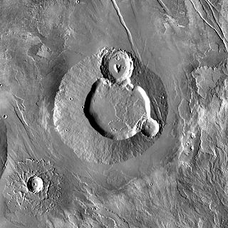
PateraPAT-ər-ə is an irregular crater, or a complex crater with scalloped edges on a celestial body. Paterae can have any origin, although the majority of them were created by volcanism. The term comes from Latin language, where it refers to a shallow bowl used in antique culture.

Nili Patera is a dune field on Mars. It is located on top of a lava bed, at the site of an ancient volcano, the Nili Patera caldera of Syrtis Major, near the Martian equator, and it is one of the most active dune fields of Mars. Its location coordinates on Mars are 8.7° N latitude, 67.3° E longitude. It is being actively studied by the HiRISE camera, on board the Mars Reconnaissance Orbiter, at the rate of one image every six weeks. The study of the movement of the dunes provides information regarding wind variation as a function of time and furthers the study of surface erosion characteristics of the Martian landscape. This information can then be used for the development and design of future Mars expeditions. The dunes of the Patera field are of the barchan type and their study by HiRISE was the first one to establish dune and ripple movement of a minimum of 1 metre on Mars. The Patera dune field, was also the first to be investigated using the COSI-Corr software, which was originally developed to analyse the movement of earthbound dunes. The research results from the evidence provided by the monitoring of the Nili Patera field, indicate sand fluxes of the order of several cubic metres per metre per year, similar to the flux observed at the sand dunes of Victoria Valley in Antarctica.

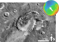
Siloe Patera is a patera in the Arabia Terra area on the planet Mars. Lying south of the Martian dichotomy boundary, it measures 30 km (19 mi) x 40 km (25 mi) across. The patera is a collection of deep craters that extend approximately 1,750 m (5,740 ft) beneath the Arabia Terra surface. It features scarps, faults and steep crater walls. Extending 60 km (37 mi) from the southwestern part of the crater are thought to be lava or pyroclastic flows. One of several irregularly-shaped craters in the region, it is thought to be the caldera of a supervolcano, according to research by J. R. Michalski and J. E. Bleacher in 2013. The caldera formed when a volcanic structure collapsed. The scientists speculated that it is a caldera rather than an impact crater because of its irregular shape, the absence of a raised rim or central peak, and lack of impact ejecta. These explosive volcanoes erupted during the planet's first billion years. They are thought to have produced fine-grained sediments that deposited in layers.