Peace Vallis

Last updated

Peace Vallis
PIA16158-Mars Curiosity Rover-Water-AlluvialFan.jpg
Peace Vallis and related alluvial fan near the Curosity rover landing ellipse and landing site (Bradbury Landing) (noted by cross [+]).
Coordinates 4°13′S137°14′E / 4.21°S 137.23°E / -4.21; 137.23
Length35.24 km (21.90 mi)
NamingAdopted by the IAU on September 26, 2012, after the Peace River in British Columbia and Alberta, Canada. [1]

Peace Vallis is an ancient stream valley on the northern rim of Gale Crater on the planet Mars. It is notable for its associated alluvial fan which lies near the Mars Science Laboratory Curiosity landing site (Bradbury Landing). The valley and alluvial fan provide evidence for geologically recent (Amazonian-aged) fluvial activity [2] [3] and sustained water flow [4] on Mars. Recent high-resolution orbital images of Peace Vallis and its watershed also suggest that at least one glacial episode affected Gale crater. [5] All of this evidence has implications for the history of water on Mars and the planet's long-term habitability. [6] Understanding Peace Vallis and its fan also provides geologic context for the rocks observed on the ground by the Curiosity rover. [7]

Contents

Location and Regional Context

The valley is centered at 4°13′S137°14′E / 4.21°S 137.23°E / -4.21; 137.23 [1] in the northeastern Aeolis quadrangle of Mars and drains approximately 1,500 square kilometers (580 sq mi) of the northern rim of Gale Crater. [8] While the stream was active, surface water and groundwater drained to the south into a low-lying plain in the northern interior of the crater (Aeolis Palus) where the stream valley debouched into a large alluvial fan (Peace Vallis fan).

Gale crater itself is a 154-kilometer (96 mi)-diameter impact crater that straddles the martian hemispheric dichotomy between the heavily cratered southern highlands and the lower elevation plains (Elysium Planitia) to the north. Gale crater is noteworthy for its enigmatic 5-kilometer (3.1 mi)-high crescent-shaped central mound, Aeolis Mons (known informally as Mt. Sharp). The crater is late Noachian or Early Hesperian in age (approximately 3.65 to 3.55 billion years old). [9]

The northern rim of Gale Crater is heavily eroded and hosts a number of geomorphic features indicating the effects of flowing water. These include valleys, gullies, and canyons; sinuous ridges interpreted to be inverted channels; and alluvial fan-like mesas. [10] Peace Vallis and its alluvial fan is the largest and best studied of these fluvial features in northern Gale Crater.

Name

Peace Vallis is named after the Peace River in Alberta and British Columbia, Canada. The name was adopted by the International Astronomical Union (IAU) on September 26, 2012. Vallis is the Latin word for valley. [1]

Valley and Drainage Basin

Peace Vallis is a valley network characterized by a branching (dendritic) pattern of tributary valleys that resembles river drainage basins on Earth. They are common on the older heavily cratered regions of Mars. Most planetary scientists agree that valley networks were formed by flowing water, but the source of the water is still debated. [11] Some argue that rainfall on a warm and wet early mars produced them. [12] Others have suggested they were produced by mass wasting, [13] spring sapping, [14] or from snowmelt [15] on an ancient Mars whose climate was dry and cold much like today's.

The Peace Vallis drainage basin (or catchment) covers an area of about 1,500 km2 (579 mi2). This area sits 1,300 m (4,265 ft) [5] above the crater floor and consists of gently sloping plains interspersed with hills roughly 100 to 350 m (328 to 1,148 ft) high. These irregular hills are mostly mantled with debris that appear to be some combination of aeolian deposits and colluvium. [16] Erosion of the watershed surface has produced a mottled scoured appearance, suggesting mobilization and transport of sediments into topographic lows.

Compared with most terrestrial valleys carved by rainfall, the drainage density (stream length per unit area) of Peace Vallis and its tributaries is very low. There is a lack of highly integrated fluvial channels, [17] and the areas between the tributary valleys (interfluves) are undissected by smaller valleys or gullies. The drainage density of the Peace Vallis system has been estimated to be 0.15 km–1. [16] In contrast, drainage densities of rivers on Earth range from 2 to 30 km–1. [18] Factors that control drainage density include slope, rock type (which determines infiltration capacity) [19] and climate (mainly precipitation). The low drainage density of Peace Vallis suggests an environment of relatively gentle slopes, very low (or infrequent) precipitation, permeable soils or bedrock, or some combination of the three. [20]

The valleys are U-shaped in topographic profile, with widths ranging from 80 to 900 meters (262 to 2,950 feet) and a mean of 300 meters (984 feet). The main or trunk valley is about 32 km (20 miles) long. [16]

Evidence of water on Mars near Peace Vallis [21] [22] [23]
Peace river course.jpg
Main valley and tributaries of Peace Vallis (shown in blue).
PIA16156-Mars Curiosity Rover-Water-AncientStreambed.jpg
"Hottah" rock outcrop on Mars - an ancient streambed viewed by the Curiosity rover (September 14, 2012) (close-up) (3-D version)
PIA16189 fig1-Curiosity Rover-Rock Outcrops-Mars and Earth.jpg
"Link" rock outcrop on Mars - compared with a terrestrial fluvial conglomerate - suggesting water "vigorously" flowing in a stream.
Curiosity rover on the way to Glenelg (September 26, 2012).

Curiosity rover landed near the end of the Peace Vallis fan. Peace Vallis fan covers 80 km2 (31 sq mi) and obtained water from an area of 730 km2 (280 sq mi). Peace Vallis enters Gale Crater through a 15 km-wide (9.3 mi) gap in its rim. Calculations suggest that the fan has an average thickness of 9 m (30 ft). Numerous inverted channels are visible on the western surface of the fan. Runoff through Peace Vallis that made the fan is estimated to be between 600 and 6,000 m (0.37 and 3.73 mi); therefore a hydrologic cycle probably lasted at least thousands of years. The water that flowed in Peace Vallis is believed to be from precipitation, possibly in the form of snow. [16]

Images

See also

Related Research Articles

<span class="mw-page-title-main">Holden (Martian crater)</span> Martian crater

Holden is a 140 km wide crater situated within the Margaritifer Sinus quadrangle (MC-19) region of the planet Mars, located with the southern highlands. It is named after American astronomer Edward Singleton Holden. It is part of the Uzboi-Landon-Morava (ULM) system.

<span class="mw-page-title-main">Eberswalde (crater)</span> Crater on Mars

Eberswalde, formerly known as Holden NE, is a partially buried impact crater in Margaritifer Terra, Mars. Eberswalde crater lies just to the north of Holden, a large crater that may have been a lake. The 65.3-km-diameter crater, centered at 24°S, 33°W, is named after the German town of the same name, in accordance with the International Astronomical Union's rules for planetary nomenclature. It was one of the final four proposed landing sites for the Mars rover Mars Science Laboratory mission. This extraterrestrial geological feature lies situated within the Margaritifer Sinus quadrangle (MC-19) region of Mars. Although not chosen, it was considered a potential landing site for the Mars 2020 Perseverance rover, and in the second Mars 2020 Landing Site Workshop it survived the cut and was among the top eight sites still in the running.

<span class="mw-page-title-main">Gale (crater)</span> Martian crater

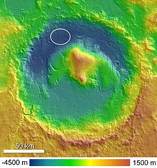
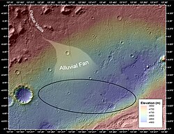
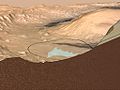
Gale is a crater, and probable dry lake, at 5.4°S 137.8°E in the northwestern part of the Aeolis quadrangle on Mars. It is 154 km (96 mi) in diameter and estimated to be about 3.5–3.8 billion years old. The crater was named after Walter Frederick Gale, an amateur astronomer from Sydney, Australia, who observed Mars in the late 19th century. Mount Sharp is a mountain in the center of Gale and rises 5.5 km (18,000 ft) high. Aeolis Palus is the plain between the northern wall of Gale and the northern foothills of Aeolis Mons. Peace Vallis, a nearby outflow channel, 'flows' down from the hills to the Aeolis Palus below and seems to have been carved by flowing water. Several lines of evidence suggest that a lake existed inside Gale shortly after the formation of the crater.

<span class="mw-page-title-main">Lunae Palus quadrangle</span> Quadrangle map of Mars

The Lunae Palus quadrangle is one of a series of 30 quadrangle maps of Mars used by the United States Geological Survey (USGS) Astrogeology Research Program. The quadrangle is also referred to as MC-10. Lunae Planum and parts of Xanthe Terra and Chryse Planitia are found in the Lunae Palus quadrangle. The Lunae Palus quadrangle contains many ancient river valleys.

<span class="mw-page-title-main">Aeolis quadrangle</span> One of a series of 30 quadrangle maps of Mars

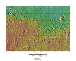
The Aeolis quadrangle is one of a series of 30 quadrangle maps of Mars used by the United States Geological Survey (USGS) Astrogeology Research Program. The Aeolis quadrangle is also referred to as MC-23 . The Aeolis quadrangle covers 180° to 225° W and 0° to 30° south on Mars, and contains parts of the regions Elysium Planitia and Terra Cimmeria. A small part of the Medusae Fossae Formation lies in this quadrangle.

<span class="mw-page-title-main">Margaritifer Sinus quadrangle</span> One of a series of 30 quadrangle maps of Mars

The Margaritifer Sinus quadrangle is one of a series of 30 quadrangle maps of Mars used by the United States Geological Survey (USGS) Astrogeology Research Program. The Margaritifer Sinus quadrangle is also referred to as MC-19. The Margaritifer Sinus quadrangle covers the area from 0° to 45° west longitude and 0° to 30° south latitude on Mars. Margaritifer Sinus quadrangle contains Margaritifer Terra and parts of Xanthe Terra, Noachis Terra, Arabia Terra, and Meridiani Planum.

<span class="mw-page-title-main">Aeolis Mensae</span> A group of mensae on Mars

Aeolis Mensae is a tableland feature in the northwest Aeolis quadrangle of Mars. Its location is centered at 2.9° south latitude and 219.6° west longitude, in the transition zone between the Martian highlands and lowlands. It is 820 kilometres (510 mi) long and was named after a classical albedo feature (Aeolis). The constituent mensae can be as long as 70 kilometres (43 mi) and as tall as 2 kilometres (1.2 mi). It is notable for being the origin of an abnormal concentration of methane detected by Curiosity in 2019, although its geology has attracted scientific attention since at least a decade before this event. Aeolis Mensae is also the first region in Mars where submarine cyclic steps, an erosion feature that gives evidence of an ancient ocean, were identified.

<span class="mw-page-title-main">Composition of Mars</span> Branch of the geology of Mars

The composition of Mars covers the branch of the geology of Mars that describes the make-up of the planet Mars.

<span class="mw-page-title-main">Mount Sharp</span> Martian mountain

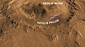
Mount Sharp, officially Aeolis Mons, is a mountain on Mars. It forms the central peak within Gale crater and is located around 5.08°S 137.85°E, rising 5.5 km (18,000 ft) high from the valley floor. Its ID in the United States Geological Survey's Gazetteer of Planetary Nomenclature is 15000.

<span class="mw-page-title-main">Aeolis Palus</span> Palus on Mars

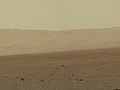
Aeolis Palus is a plain between the northern wall of Gale crater and the northern foothills of Aeolis Mons on Mars. It is located at 4.47°S 137.42°E.

<span class="mw-page-title-main">Bradbury Landing</span> Landing site of Curiosity rover

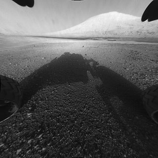
Bradbury Landing is the August 6, 2012, landing site within Gale crater on planet Mars of the Mars Science Laboratory (MSL) Curiosity rover. On August 22, 2012, on what would have been his 92nd birthday, NASA named the site for author Ray Bradbury, who had died on June 5, 2012. The coordinates of the landing site on Mars are: 4.5895°S 137.4417°E.

<span class="mw-page-title-main">Jake Matijevic (rock)</span> Rock on Mars

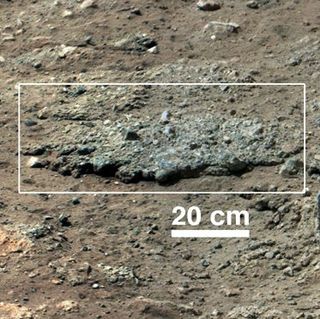
Jake Matijevic is a pyramidal rock on the surface of Aeolis Palus, between Peace Vallis and Aeolis Mons, in Gale crater on the planet Mars. The approximate site coordinates are: 4.59°S 137.44°E.

<span class="mw-page-title-main">Hottah (Mars)</span> Rock outcrop on the surface of Aeolis Palus

Hottah is a rock outcrop on the surface of Aeolis Palus, between Peace Vallis and Aeolis Mons, in Gale crater on the planet Mars.

<span class="mw-page-title-main">Rocknest (Mars)</span> Sandpatch

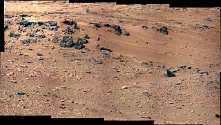
Rocknest is a sand patch on the surface of Aeolis Palus, between Peace Vallis and Aeolis Mons, in Gale crater on the planet Mars. The patch was encountered by the Curiosity rover on the way from Bradbury Landing to Glenelg Intrigue on September 28, 2012. The approximate site coordinates are: 4.59°S 137.44°E.

<span class="mw-page-title-main">Link (Mars)</span> Rock outcrop on Mars

Link is a rock outcrop on the surface of Aeolis Palus, between Peace Vallis and Aeolis Mons, in Gale crater on the planet Mars. The outcrop was encountered by the Curiosity rover on the way from Bradbury Landing to Glenelg Intrigue on September 2, 2012, and was named after a significant rock formation in the Northwest Territories of Canada. The "approximate" site coordinates are: 4.59°S 137.44°E.

<span class="mw-page-title-main">Goulburn (Mars)</span> Outcrop on Mars

Goulburn, also known as Goulburn Scour, is a rock outcrop on the surface of Aeolis Palus, between Peace Vallis and Aeolis Mons, in Gale crater on the planet Mars. The outcrop was encountered by the Curiosity rover on landing at the Bradbury Landing on August 6, 2012 and is named after a two-billion year-old sequence of rocks in Northern Canada. The "approximate" site coordinates are: 4.59°S 137.44°E.

<span class="mw-page-title-main">Rocknest 3</span> Martian rock

Rocknest 3 is a rock on the surface of Aeolis Palus, between Peace Vallis and Aeolis Mons, in Gale crater on the planet Mars. The approximate site coordinates are: 4.59°S 137.44°E.

<span class="mw-page-title-main">Tintina (rock)</span> Rock on the surface of Mars

Tintina is a rock on the surface of Aeolis Palus, between Peace Vallis and Aeolis Mons, in Gale crater on the planet Mars. The approximate site coordinates are: 4.59°S 137.44°E.

<span class="mw-page-title-main">Yellowknife Bay, Mars</span>

Yellowknife Bay is a geologic formation in Gale Crater on the planet Mars. NASA's Mars Science Laboratory rover, named Curiosity, arrived at the low lying depression on December 17, 2012, 125 sols, or Martian days, into its 668-sol planned mission on the planet. Primary mission goals of the Mars Science Laboratory were to assess the potential habitability of the planet and whether or not the Martian environment is, or has ever been, capable of supporting life.

<span class="mw-page-title-main">Lakes on Mars</span> Overview of the presence of lakes on Mars

In summer 1965, the first close-up images from Mars showed a cratered desert with no signs of water. However, over the decades, as more parts of the planet were imaged with better cameras on more sophisticated satellites, Mars showed evidence of past river valleys, lakes and present ice in glaciers and in the ground. It was discovered that the climate of Mars displays huge changes over geologic time because its axis is not stabilized by a large moon, as Earth's is. Also, some researchers maintain that surface liquid water could have existed for periods of time due to geothermal effects, chemical composition or asteroid impacts. This article describes some of the places that could have held large lakes.

References

  1. 1 2 3 "Gazetteer of Planetary Nomenclature: Peace Vallis". IAU . September 26, 2012. Retrieved September 28, 2012.
  2. Newsom, H.E.; Scuderi, L.A.; Gallegos, Z.E.; Williams, J.M.; Dimitracopoulos, F.D.; Tornabene, L.L.; Wiens, R.C.; Gasnault, O. (2021). Evidence for Glacial and Fluvial Processes on Gale Crater Rim—Dulce Vallis. 52nd Lunar and Planetary Science Conference, Abstract #2256. https://www.hou.usra.edu/meetings/lpsc2021/pdf/2256.pdf.
  3. Ehlmann, Bethany L.; Buz, Jennifer (January 28, 2015). "Mineralogy and fluvial history of the watersheds of Gale, Knobel, and Sharp craters: A regional context for the Mars Science Laboratory Curiosity's exploration". Geophysical Research Letters. 42 (2): 264–273. doi:10.1002/2014GL062553. ISSN   0094-8276.
  4. Williams, R.M.E.; Grotzinger, J.P.; Dietrich, W.E.; Gupta, S.; Sumner, D.Y. et al. (2013). Martian Fluvial Conglomerates at Gale Crater. Science,340, 1068, doi: 10.1126/science.1237317.
  5. 1 2 Newsom, H.E.; Scuderi, L.A.; Gallegos, Z.E.; Tornabene, L.L.; Wiens, R.C. (2020). Evidence for Glacial Processes on Gale Crater Rim Surfaces from New HiRise Observations. 51st Lunar and Planetary Science Conference, Abstract #2609. https://www.hou.usra.edu/meetings/lpsc2020/pdf/2609.pdf.
  6. Scuderi, L.A.; Gallegos, Z.E.; Newsom, H.E.; Wiens, R..C. (2019). Amazonian Groundwater Springline at Peace Vallis Fan, Gale Crater; Implications for a Late Period of Surface Habitability. Mars Extant Life: What's Next? Conference, Abstract #5043. https://www.hou.usra.edu/meetings/lifeonmars2019/pdf/5043.pdf.
  7. Palucis, M.C.; Dietrich, W.E.; Hayes, A.; Williams, R.M.E. et al. (2013). Origin and Evolution of the Peace Vallis Fan System that Drains into the Curiosity Landing Area, Gale Crater. "44th Lunar and Planetary Science Conference", Abstract #1607. https://www.lpi.usra.edu/meetings/lpsc2013/pdf/1607.pdf.
  8. Newsom, H.E.; Scuderi, L.A.; Gallegos, Z.E.; Nagle-McNaughton, T.P.; Tornabene, L.L. et al. (2019). Southern Watershed and Fluvial History of the Peace Vallis Fan System, Gale Crater, Mars. 9th International Conference on Mars, Abstract #6119. https://www.hou.usra.edu/meetings/ninthmars2019/pdf/6119.pdf.
  9. Le Deit, L.; Hauber, E.; Fueten, F.; Pondrelli, M.; Pio Rossi, A.; Jaumann, R. (2013). Sequence of Infilling Events in Gale Crater, Mars: Results from Morphology, Stratigraphy, and Mineralogy. J. Geophys. Res.,118, 2439–2473, doi:10.1002/2012JE004322, 2013.
  10. Anderson, R.B.; Bell, J.F. (2010). Geologic Mapping and Characterization of Gale Crater and Implications for Its Potential as a Mars Science Laboratory Landing Site. Mars,5, 76–128.
  11. Carr, M.H. The Surface of Mars; Cambridge University Press: New York, 2006
  12. Craddock, Robert A.; Howard, Alan D. "The case for rainfall on a warm, wet early Mars". Journal of Geophysical Research: Planets. 107 (E11). doi:10.1029/2001JE001505. ISSN   0148-0227.
  13. Carr, M.H. (1995). The Martian Drainage System and the Origin of Valley Networks and Fretted Channels. J. Geophys. Res.,100(E4), 7479–7507.
  14. Squyres, S.W. (1989). Early Mars: Wet and Warm, or Just Wet? 20th Lunar and Planetary Science Conference Abstract #1044.
  15. Carr, M.H. and Head, J.W. (2003). Basal Melting of Snow on Early Mars: A Possible Origin of Some Valley Networks. Geophys. Res. Lett.,30(24), 2245, doi:10.1029/2003GL018575.
  16. 1 2 3 4 Palucis, Marisa C.; Dietrich, William E.; Hayes, Alexander G.; Williams, Rebecca M. E.; Gupta, Sanjeev; Mangold, Nicholas; Newsom, Horton; Hardgrove, Craig; Calef, Fred; Sumner, Dawn Y. "The origin and evolution of the Peace Vallis fan system that drains to the Curiosity landing area, Gale Crater, Mars". Journal of Geophysical Research: Planets. 119 (4): 705–728. doi:10.1002/2013JE004583. ISSN   2169-9097.
  17. Newsom, H.E.; Scuderi, L.A.; Gallegos, Z.E. et al. (2020). New HiRISE Observations of Gale Crater Rim Surfaces—Evidence for Glacial Processes. American Geophysical Union, Fall Meeting, No. P038-01.
  18. Carr, M.C. Water on Mars. Oxford University Press: New York, 2006, 229 pp.
  19. Melosh, H.J. Planetary Surface Processes. Cambridge University Press: Cambridge U.K., 2011, 500 pp.
  20. Huggett, R.J. Fundamentals of Geomorphology. Routledge: New York, 2007, 483 pp.
  21. Brown, Dwayne; Cole, Steve; Webster, Guy; Agle, D.C. (September 27, 2012). "NASA Rover Finds Old Streambed On Martian Surface". NASA . Retrieved September 28, 2012.
  22. NASA's Curiosity Rover Finds Old Streambed on Mars - video (51:40). NASAtelevision. September 27, 2012. Retrieved September 28, 2012 via YouTube.
  23. Chang, Alicia (September 27, 2012). "Mars rover Curiosity finds signs of ancient stream". AP News . Retrieved September 27, 2012.