A Martian meteorite is a rock that formed on Mars, was ejected from the planet by an impact event, and traversed interplanetary space before landing on Earth as a meteorite. As of September 2020, 277 meteorites had been classified as Martian, less than half a percent of the 72,000 meteorites that have been classified. The largest complete, uncut Martian meteorite, Taoudenni 002, was recovered in Mali in early 2021. It weighs 14.5 kilograms and is on display at the Maine Mineral & Gem Museum.

The Memnonia quadrangle is one of a series of 30 quadrangle maps of Mars used by the United States Geological Survey (USGS) Astrogeology Research Program. The Memnonia quadrangle is also referred to as MC-16.

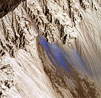
An ejecta blanket is a generally symmetrical apron of ejecta that surrounds an impact crater; it is layered thickly at the crater's rim and thin to discontinuous at the blanket's outer edge. The impact cratering is one of the basic surface formation mechanisms of the solar system bodies and the formation and emplacement of ejecta blankets are the fundamental characteristics associated with impact cratering event. The ejecta materials are considered as the transported materials beyond the transient cavity formed during impact cratering regardless of the state of the target materials.

Crater counting is a method for estimating the age of a planet's surface based upon the assumptions that when a piece of planetary surface is new, then it has no impact craters; impact craters accumulate after that at a rate that is assumed known. Consequently, counting how many craters of various sizes there are in a given area allows determining how long they have accumulated and, consequently, how long ago the surface has formed. The method has been calibrated using the ages obtained by radiometric dating of samples returned from the Moon by the Luna and Apollo missions. It has been used to estimate the age of areas on Mars and other planets that were covered by lava flows, on the Moon of areas covered by giant mares, and how long ago areas on the icy moons of Jupiter and Saturn flooded with new ice.

Tooting is an impact crater with volcanic features at 23.1°N, 207.1°E, in Amazonis Planitia, due west of the volcano Olympus Mons, on Mars. It was identified by planetary geologist Peter Mouginis-Mark in September 2004. Scientists estimate that its age is on the order of hundreds of thousands of years, which is relatively young for a Martian crater. A later study confirms this order of magnitude estimate. A preliminary paper describing the geology and geometry of Tooting was published in 2007 by the journal Meteoritics and Planetary Science, vol. 42, pages 1615–1625. Further papers have been published, including a 2010 analysis of flows on the walls of Tooting crater by A. R. Morris et al., and a 2012 review paper by P.J. Mouginis-Mark and J.M. Boyce in Chemie der Erde Geochemistry, vol. 72, p. 1–23. A geologic map has also been submitted in 2012 to the U.S. Geological Survey for consideration and future publication.

The Athabasca Valles are a late Amazonian-period outflow channel system in the central Elysium Planitia region of Mars, located to the south of the Elysium Rise. They are part of a network of outflow channels in this region that are understood to emanate from large fissures in the Martian surface rather than the chaos terrains that source the circum-Chryse outflow channels. The Athabasca Valles in particular emanate from one of the Cerberus Fossae fissures and flow downstream to the southwest, constrained to the south by a wrinkle ridge for over 100 km, before debouching into the Cerberus Palus volcanic plain. The Athabasca Valles are widely understood to be the youngest outflow channel system on the planet.

The Noachis quadrangle is one of a series of 30 quadrangle maps of Mars used by the United States Geological Survey (USGS) Astrogeology Research Program. The Noachis quadrangle is also referred to as MC-27.

The Elysium quadrangle is one of a series of 30 quadrangle maps of Mars used by the United States Geological Survey (USGS) Astrogeology Research Program. The Elysium quadrangle is also referred to as MC-15.

The Amazonis quadrangle is one of a series of 30 quadrangle maps of Mars used by the United States Geological Survey (USGS) Astrogeology Research Program. The Amazonis quadrangle is also referred to as MC-8.

The Tharsis quadrangle is one of a series of 30 quadrangle maps of Mars used by the United States Geological Survey (USGS) Astrogeology Research Program. The Tharsis quadrangle is also referred to as MC-9 . The name Tharsis refers to a land mentioned in the Bible. It may be at the location of the old town of Tartessus at the mouth of Guadalquivir.
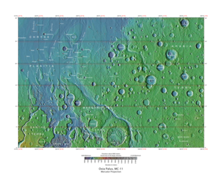
The Oxia Palus quadrangle is one of a series of 30 quadrangle maps of Mars used by the United States Geological Survey (USGS) Astrogeology Research Program. The Oxia Palus quadrangle is also referred to as MC-11.

The Phoenicis Lacus quadrangle is one of a series of 30 quadrangle maps of Mars used by the United States Geological Survey (USGS) Astrogeology Research Program. The Phoenicis Lacus quadrangle is also referred to as MC-17. Parts of Daedalia Planum, Sinai Planum, and Solis Planum are found in this quadrangle. Phoenicis Lacus is named after the phoenix which according to myth burns itself up every 500 years and then is reborn.

The Margaritifer Sinus quadrangle is one of a series of 30 quadrangle maps of Mars used by the United States Geological Survey (USGS) Astrogeology Research Program. The Margaritifer Sinus quadrangle is also referred to as MC-19. The Margaritifer Sinus quadrangle covers the area from 0° to 45° west longitude and 0° to 30° south latitude on Mars. Margaritifer Sinus quadrangle contains Margaritifer Terra and parts of Xanthe Terra, Noachis Terra, Arabia Terra, and Meridiani Planum.

The Thaumasia quadrangle is one of a series of 30 quadrangle maps of Mars used by the United States Geological Survey (USGS) Astrogeology Research Program. The Thaumasia quadrangle is also referred to as MC-25 . The name comes from Thaumas, the god of the clouds and celestial apparitions.

The Mare Australe quadrangle is one of a series of 30 quadrangle maps of Mars used by the United States Geological Survey (USGS) Astrogeology Research Program. The Mare Australe quadrangle is also referred to as MC-30. The quadrangle covers all the area of Mars south of 65°, including the South polar ice cap, and its surrounding area. The quadrangle's name derives from an older name for a feature that is now called Planum Australe, a large plain surrounding the polar cap. The Mars polar lander crash landed in this region.

Trouvelot is a crater on Mars, located in the Oxia Palus quadrangle at 16.2° north latitude and 13.1° west longitude near the crustal dichotomy in the circum-Chryse region. It is roughly located along the dichotomy between Arabia Terra to the northeast and the southernmost of the circum-Chryse outflow channels to the southwest. Trouvelot crater measures approximately 148.77 kilometres (92.44 mi) in diameter and was named after Étienne Léopold Trouvelot, a French astronomer (1827–1895). The name was adopted by IAU's Working Group for Planetary System Nomenclature in 1973.

Arandas is a crater in the Mare Acidalium quadrangle of Mars, located 42.77° North and 15.17° West. It is 24.76 km (15.39 mi) in diameter and is named after the town of Arandas in Mexico.

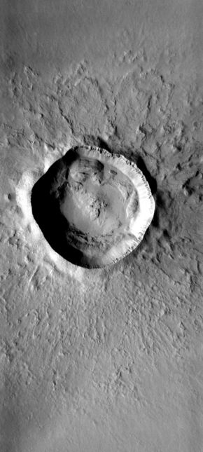
Mojave is a 58 km diameter impact crater in the Oxia Palus quadrangle of Mars, located at 7.5° N and 33.0° W. It was named after the town of Mojave in southern California, U.S.

Resen is a crater in the Mare Tyrrhenum quadrangle on Mars, located at 28.22° South and 251.13° West. It is measures 7.4 kilometers in diameter and was named after the town of Resen in North Macedonia. The naming was approved by IAU's Working Group for Planetary System Nomenclature on 19 January 2011.
There are a number of different types of craters that have been observed and studied on Mars. Many of them are shaped by the effects of impacts into ice-rich ground.