
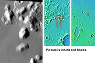
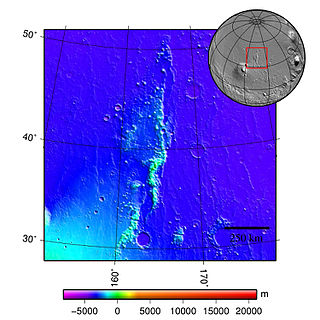
Tartarus Colles are a group of knobby hills in the northern plains of Mars.
Tartarus Colles are a group of knobby hills in the northern plains of Mars.
Tartarus Colles runs from 8° to 33° north latitude and 170° to 200° west longitude. They were named after a classic albedo feature. The name was officially approved by the IAU in 1985. [1] The term "Colles" is used for small hills or knobs. [2]
There are over 40,000 knobs associated with Tartarus Colles. [3]
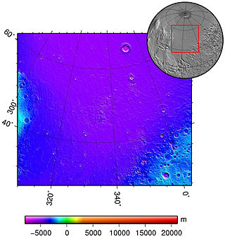
This landform is located within the Diacria quadrangle of Mars.
Some researchers have proposed that the knobs of western Tartarus Colles are consistent with concurrent interpretations of knobs in Cerberus Palus (downstream of Athabasca Valles), which would suggest that they formed as the result of interactions between lava and water to form what has been termed by some authors as volcanic rootless constructs (VRC). This class of lava-water interactions includes rootless cones, but have fewer genetic implications in their definition, as are not necessarily phreatomagmatic (resulting from the explosion of steam from the sudden evaporation of fluids on contact with lava). The water source is not required to have been added en masse in the form of some aqueous flood - instead possibly being available in the form of an extremely thin and shallow ground ice reservoir whose presence and extent is controlled by obliquity as an orbital forcer. [3]
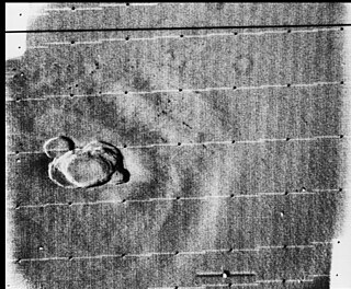
In 2008, Mark A. Bishop of the Planetary Science Institute and the University of South Australia reported on his results using higher-order neighbor analysis to attempt to discern any kind of pattern in the distribution of Tartarus Colles' knobs. The purpose of the study was to reconcile competing hypotheses as to the origin of these knobby landforms, which had been analogized by other authors to putative pingoes and rootless cones in Athabasca Valles and elsewhere in Elysium Planitia. Bishop found the cones of Tartarus Colles to exhibit a complete spatial randomness except where solifluction or magmatic effects were readily apparent. [4]
In 2011, Christopher W. Hamilton and Sarah A. Fagents of the University of Hawaiʻi at Mānoa in Honolulu, Hawaii, and Thorvaldur Thordarson of the University of Edinburgh in Scotland reported on the results of their geomorphic mapping, lava thickness estimations, and statistical analyses (nearest neighbor modeling) to investigate the hypotheses that the cones of Tartarus Colles are what the authors have termed "volcanic rootless constructs" - a more generalized variation of the term "rootless cone" that does not explicitly require a phreatomagmatic origin, or any clear explosive expression such as a pseudocrater. The authors criticize the tendency to generalize Martian pseudocrater analogies against Mývatn, the Icelandic lake, which has been used as a type example of structures arising on Mars from water-lava interactions in a way that ignores the variability of such structures even across Iceland. [3]


Volcanic cones are among the simplest volcanic landforms. They are built by ejecta from a volcanic vent, piling up around the vent in the shape of a cone with a central crater. Volcanic cones are of different types, depending upon the nature and size of the fragments ejected during the eruption. Types of volcanic cones include stratocones, spatter cones, tuff cones, and cinder cones.

A rootless cone, also formerly called a pseudocrater, is a volcanic landform which resembles a true volcanic crater, but differs in that it is not an actual vent from which lava has erupted. They are characterised by the absence of any magma conduit which connects below the surface of a planet.

Elysium, located in the Elysium and Cebrenia quadrangles, is the second largest volcanic region on Mars, after Tharsis. The region includes the volcanoes Hecates Tholus, Elysium Mons and Albor Tholus. The province is centered roughly on Elysium Mons at 24.7°N 150°E. Elysium Planitia is a broad plain to the south of Elysium, centered at 3.0°N 154.7°E. Another large volcano, Apollinaris Mons, lies south of Elysium Planitia and is not part of the province. Besides having large volcanoes, Elysium has several areas with long trenches, called fossa or fossae (plural) on Mars. They include the Cerberus Fossae, Elysium Fossae, Galaxias Fossae, Hephaestus Fossae, Hyblaeus Fossae, Stygis Fossae and Zephyrus Fossae.
Acidalia Planitia is a plain on Mars, between the Tharsis volcanic province and Arabia Terra to the north of Valles Marineris, centered at 49.8°N 339.3°E. Most of this region is found in the Mare Acidalium quadrangle, but a small part is in the Ismenius Lacus quadrangle. The plain contains the famous Cydonia region at the contact with the heavily cratered highland terrain.

The Cerberus Fossae are a series of semi-parallel fissures on Mars formed by faults which pulled the crust apart in the Cerberus region. They are 1235 km across and centered at 11.28 °N and 166.37 °E. Their northernmost latitude is 16.16 °N and their southernmost latitude 6.23 °N. Their easternmost and westernmost longitudes are 174.72 °E and 154.43 °E, respectively. They can be seen in the Elysium quadrangle.
Phreatomagmatic eruptions are volcanic eruptions resulting from interaction between magma and water. They differ from exclusively magmatic eruptions and phreatic eruptions. Unlike phreatic eruptions, the products of phreatomagmatic eruptions contain juvenile (magmatic) clasts. It is common for a large explosive eruption to have magmatic and phreatomagmatic components.

The Athabasca Valles are a late Amazonian-period outflow channel system in the central Elysium Planitia region of Mars, located to the south of the Elysium Rise. They are part of a network of outflow channels in this region that are understood to emanate from large fissures in the Martian surface rather than the chaos terrains that source the circum-Chryse outflow channels. The Athabasca Valles in particular emanate from one of the Cerberus Fossae fissures and flow downstream to the southwest, constrained to the south by a wrinkle ridge for over 100 km, before debouching into the Cerberus Palus volcanic plain. The Athabasca Valles are widely understood to be the youngest outflow channel system on the planet.

Apollinaris Mons is an ancient shield volcano in the southern hemisphere of Mars. It is situated near the equator, south of Elysium Planitia and north of the impact crater Gusev. Elysium Planitia separates it from the volcanic province of Elysium to its northwest. The volcano's caldera is named Apollinaris Patera; this name formerly applied to the whole edifice.
Volcanic activity, or volcanism, has played a significant role in the geologic evolution of Mars. Scientists have known since the Mariner 9 mission in 1972 that volcanic features cover large portions of the Martian surface. These features include extensive lava flows, vast lava plains, and the largest known volcanoes in the Solar System. Martian volcanic features range in age from Noachian to late Amazonian, indicating that the planet has been volcanically active throughout its history, and some speculate it probably still is so today. Both Mars and Earth are large, differentiated planets built from similar chondritic materials. Many of the same magmatic processes that occur on Earth also occurred on Mars, and both planets are similar enough compositionally that the same names can be applied to their igneous rocks.

The Elysium quadrangle is one of a series of 30 quadrangle maps of Mars used by the United States Geological Survey (USGS) Astrogeology Research Program. The Elysium quadrangle is also referred to as MC-15.
The Phlegra Montes are a system of eroded Hesperian–Noachian-aged massifs and knobby terrain in the mid-latitudes of the northern lowlands of Mars, extending northwards from the Elysium Rise towards Vastitas Borealis for nearly 1,400 km (870 mi). The mountain ranges separate the large plains provinces of Utopia Planitia (west) and Amazonis Planitia (east), and were named in the 1970s after a classical albedo feature. The massif terrains are flanked by numerous parallel wrinkle ridges known as the Phlegra Dorsa.
Outflow channels are extremely long, wide swathes of scoured ground on Mars. They extend many hundreds of kilometers in length and are typically greater than one kilometer in width. They are thought to have been carved by huge outburst floods.

Lethe Vallis is a valley in the Elysium Planitia on Mars, located at 4° North and 206.5° West. It is 225 km long and is named after river Lethe in Katmai National Monument, Alaska, USA. Lethe Vallis originates at the SE margin of the West Elysium Basin. West Elysium Basin probably contained a lake that was 500 km across and received water from Athabasca Vallis. It was probably formed in just days or weeks and had a discharge about like the Mississippi. Some have suggested it was formed from lava flows, but lava would not be able to flow over such a low gradient for so long a distance.
HiWish is a program created by NASA so that anyone can suggest a place for the HiRISE camera on the Mars Reconnaissance Orbiter to photograph. It was started in January 2010. In the first few months of the program 3000 people signed up to use HiRISE. The first images were released in April 2010. Over 12,000 suggestions were made by the public; suggestions were made for targets in each of the 30 quadrangles of Mars. Selected images released were used for three talks at the 16th Annual International Mars Society Convention. Below are some of the over 4,224 images that have been released from the HiWish program as of March 2016.

The Mars Reconnaissance Orbiter's HiRISE instrument has taken many images that strongly suggest that Mars has had a rich history of water-related processes. Many features of Mars appear to be created by large amounts of water. That Mars once possessed large amounts of water was confirmed by isotope studies in a study published in March 2015, by a team of scientists showing that the ice caps were highly enriched with deuterium, heavy hydrogen, by seven times as much as the Earth. This means that Mars has lost a volume of water 6.5 times what is stored in today's polar caps. The water for a time would have formed an ocean in the low-lying Mare Boreum. The amount of water could have covered the planet about 140 meters, but was probably in an ocean that in places would be almost 1 mile deep.

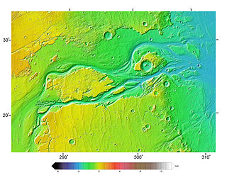
The Tartarus Montes are a mountain range on the planet Mars, stretching over 1070 km and located around the coordinates 15.46º N, 167.54º E, between Orcus Patera and the Elysium volcanic region.

The Amazonian is a geologic system and time period on the planet Mars characterized by low rates of meteorite and asteroid impacts and by cold, hyperarid conditions broadly similar to those on Mars today. The transition from the preceding Hesperian period is somewhat poorly defined. The Amazonian is thought to have begun around 3 billion years ago, although error bars on this date are extremely large. The period is sometimes subdivided into the Early, Middle, and Late Amazonian. The Amazonian continues to the present day.

Elysium Planitia, located in the Elysium and Aeolis quadrangles, is a broad plain that straddles the equator of Mars, centered at 3.0°N 154.7°E. It lies to the south of the volcanic province of Elysium, the second largest volcanic region on the planet, after Tharsis. Elysium contains the major volcanoes Elysium Mons, Albor Tholus and Hecates Tholus. Another more ancient shield volcano, Apollinaris Mons, is situated just to the south of eastern Elysium Planitia. Within the plains, Cerberus Fossae is the only Mars location with recent volcanic eruptions. Lava flows dated no older than 0.2 million years from the present have been found, and evidence has been found that volcanic activity may have occurred as recently as 53,000 years ago. Such activity could have provided the environment, in terms of energy and chemicals, needed to support life forms.

In summer 1965, the first close-up images from Mars showed a cratered desert with no signs of water. However, over the decades, as more parts of the planet were imaged with better cameras on more sophisticated satellites, Mars showed evidence of past river valleys, lakes and present ice in glaciers and in the ground. It was discovered that the climate of Mars displays huge changes over geologic time because its axis is not stabilized by a large moon, as Earth's is. Also, some researchers maintain that surface liquid water could have existed for periods of time due to geothermal effects, chemical composition, or asteroid impacts. This article describes some of the places that could have held large lakes.

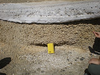
The Rauðhólar are remnants of a cluster of rootless cones in Elliðaárhraun lava fields on the south-eastern outskirts of Reykjavík, Iceland next to the South Iceland part of Hringvegur, the Suðurlandsvegur.