
NASA's Mars Exploration Rover (MER) mission was a robotic space mission involving two Mars rovers, Spirit and Opportunity, exploring the planet Mars. It began in 2003 with the launch of the two rovers to explore the Martian surface and geology; both landed on Mars at separate locations in January 2004. Both rovers far outlived their planned missions of 90 Martian solar days: MER-A Spirit was active until March 22, 2010, while MER-B Opportunity was active until June 10, 2018.

Devon Island is an island in Canada and the largest uninhabited island in the world. It is located in Baffin Bay, Qikiqtaaluk Region, Nunavut, Canada. It is one of the largest members of the Arctic Archipelago, the second-largest of the Queen Elizabeth Islands, Canada's sixth-largest island, and the 27th-largest island in the world. It has an area of 55,247 km2 (21,331 sq mi). The bedrock is Precambrian gneiss and Paleozoic siltstones and shales. The highest point is the Devon Ice Cap at 1,920 m (6,300 ft) which is part of the Arctic Cordillera. Devon Island contains several small mountain ranges, such as the Treuter Mountains, Haddington Range and the Cunningham Mountains. The notable similarity of its surface to that of Mars has attracted interest from scientists.
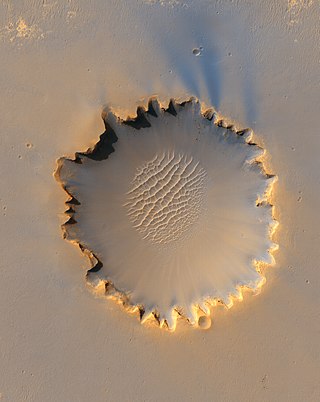
Victoria is an impact crater on Mars located at 2.05°S, 5.50°W in the Meridiani Planum extraterrestrial plain, lying situated within the Margaritifer Sinus quadrangle (MC-19) region of the planet Mars. This crater was first visited by the Mars Exploration Rover Opportunity. It is roughly 800 metres (2,600 ft) wide, nearly eight times the size of the crater Endurance, visited by Opportunity from sols 951 to 1630.

Erebus is a crater lying situated within the Margaritifer Sinus quadrangle (MC-19) region of the planet Mars, this extraterrestrial geological feature was visited by the Opportunity rover on the way to the much larger crater Victoria. It is named after the polar exploration vessel HMS Erebus which was used by James Clark Ross in 1841 to discover the Great Ice Barrier, now known as the Ross Ice Shelf. The rover was in the immediate vicinity of the crater from approximately sol 550 to 750.
Elysium Mons is a volcano on Mars located in the volcanic province Elysium, at 25.02°N 147.21°E, in the Martian eastern hemisphere. It stands about 12.6 km (41,000 ft) above its base, and about 14.1 km (46,000 ft) above the Martian datum, making it the third tallest Martian mountain in terms of relief and the fourth highest in elevation. Its diameter is about 240 km (150 mi), with a summit caldera about 14 km (8.7 mi) across. It is flanked by the smaller volcanoes Hecates Tholus to the northeast, and Albor Tholus to the southeast.

The geology of Mars is the scientific study of the surface, crust, and interior of the planet Mars. It emphasizes the composition, structure, history, and physical processes that shape the planet. It is analogous to the field of terrestrial geology. In planetary science, the term geology is used in its broadest sense to mean the study of the solid parts of planets and moons. The term incorporates aspects of geophysics, geochemistry, mineralogy, geodesy, and cartography. A neologism, areology, from the Greek word Arēs (Mars), sometimes appears as a synonym for Mars's geology in the popular media and works of science fiction. The term areology is also used by the Areological Society.

Dinorwic is a Martian impact crater, approximately 51 kilometers in diameter. It is named after the town in Ontario, Canada. Its name was approved by the International Astronomical Union in 1991. According to a surface age map of Mars based on US Geological Survey data, the area around Dinorwic is from the Noachian epoch, which places the area's age at 3.8 to 3.5 billion years ago. At the crater's rim, it is about 7,600 meters above zero altitude, and it is about 5,950 meters above zero altitude at its floor, giving it a depth of 1.6 kilometers.
Tugaske is a Martian impact crater, approximately 31 kilometres (19 mi) in diameter. It is located at 32.1°S, 101.2°W, south of the crater Dinorwic and southeast of the crater Virrat. It is named after a town in Saskatchewan, Canada, and its name was approved by the International Astronomical Union in 1991. According to a surface age map of Mars based on US Geological Survey data, the area around Tugaske is from the Noachian epoch, which places the area's age at 3.8 to 3.5 billion years ago. The elevation around the rim averages about 6,700 metres (22,000 ft) above zero altitude, and the deepest part of the crater floor, in the central pit, measures 5,100 metres (16,700 ft) above zero altitude. The crater is therefore about 1.6 kilometres (0.99 mi) deep.

Koga is an impact crater on Mars, approximately 19 kilometers in diameter. It is located at 29.3°S, 103.8°W, north of the crater Virrat and northeast of the crater Dinorwic. To the north is the crater Nhill. It is named after a town in Tanzania, and its name was approved by the International Astronomical Union in 1991. According to a surface age map of Mars based on US Geological Survey data, the area around Koga is from the Noachian epoch, which places the area's age at 3.8 to 3.5 billion years ago. Sharp blocks and cliffs poke through a mantle of fine material located at the bottom of the crater. At the deepest part of the crater, it is about 5,200 meters in elevation above zero altitude, and its rim averages about 6,400 meters above zero altitude. It is therefore approximately 1.2 kilometers deep.
Srīpur is a Martian impact crater, approximately 22.99 kilometres (14.29 mi) in diameter. It is located at -31.1°S, 100.8°W, southeast of the crater Dinorwic and northeast of the crater Tugaske. It is named for Sripur, a town in Bangladesh, and its name was adopted by the International Astronomical Union in 1991.

Gale is a crater, and probable dry lake, at 5.4°S 137.8°E in the northwestern part of the Aeolis quadrangle on Mars. It is 154 km (96 mi) in diameter and estimated to be about 3.5–3.8 billion years old. The crater was named after Walter Frederick Gale, an amateur astronomer from Sydney, Australia, who observed Mars in the late 19th century. Mount Sharp is a mountain in the center of Gale and rises 5.5 km (18,000 ft) high. Aeolis Palus is the plain between the northern wall of Gale and the northern foothills of Aeolis Mons. Peace Vallis, a nearby outflow channel, 'flows' down from the hills to the Aeolis Palus below and seems to have been carved by flowing water. Several lines of evidence suggest that a lake existed inside Gale shortly after the formation of the crater.

Mars is the fourth planet from the Sun. The surface of Mars is orange-red because it is covered in iron(III) oxide dust, giving it the nickname "the Red Planet". Mars is among the brightest objects in Earth's sky, and its high-contrast albedo features have made it a common subject for telescope viewing. It is classified as a terrestrial planet and is the second smallest of the Solar System's planets with a diameter of 6,779 km (4,212 mi). In terms of orbital motion, a Martian solar day (sol) is equal to 24.6 hours, and a Martian solar year is equal to 1.88 Earth years. Mars has two natural satellites that are small and irregular in shape: Phobos and Deimos.
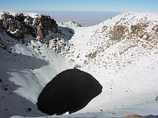
Licancabur Lake is a crater lake in Chile located on the volcano Licancabur. It is close to the city San Pedro de Atacama and also very close to the border of Chile with Bolivia.

Almost all water on Mars today exists as polar permafrost ice, though it also exists in small quantities as vapor in the atmosphere.

Endeavour is an impact crater located in the Meridiani Planum extraterrestrial plain within the Margaritifer Sinus quadrangle (MC-19) region of the planet Mars. Endeavour is about 22 kilometers (14 mi) in diameter. Using Mars Reconnaissance Orbiter data, phyllosilicate-bearing outcrops have been detected along its rim. These minerals may have formed under wet conditions in a low-acidic environment during the early history of Mars. There are raised rim segments to the north, east, and southwest. The rim has become worn, rounded and degraded, with infilling of plains material in a manner similar to the Victoria crater.
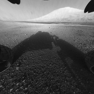
Mount Sharp, officially Aeolis Mons, is a mountain on Mars. It forms the central peak within Gale crater and is located around 5.08°S 137.85°E, rising 5.5 km (18,000 ft) high from the valley floor. Its ID in the United States Geological Survey's Gazetteer of Planetary Nomenclature is 15000.

Peace Vallis is an ancient stream valley on the northern rim of Gale Crater on the planet Mars. It is notable for its associated alluvial fan which lies near the Mars Science Laboratory Curiosity landing site. The valley and alluvial fan provide evidence for geologically recent (Amazonian-aged) fluvial activity and sustained water flow on Mars. Recent high-resolution orbital images of Peace Vallis and its watershed also suggest that at least one glacial episode affected Gale crater. All of this evidence has implications for the history of water on Mars and the planet's long-term habitability. Understanding Peace Vallis and its fan also provides geologic context for the rocks observed on the ground by the Curiosity rover.

Opportunity is a robotic rover that was active on the planet Mars from 2004 to 2018. Launched on July 7, 2003, Opportunity landed on Mars' Meridiani Planum on January 25, 2004, at 05:05 Ground UTC, three weeks after its twin Spirit (MER-A), also part of NASA's Mars Exploration Rover Mission, touched down on the other side of the planet. While Spirit became immobile in 2009, and ceased communications in 2010, Opportunity exceeded its planned 90 sol duration of activity by 14 years 46 days. Opportunity continued to move, gather scientific observations, and report back to Earth until 2018. What follows is a summary of events during its continuing mission.

Very is a crater on Mars, located south of the planet's equator in the heavily cratered highlands of Terra Sirenum in the Phaethontis quadrangle at 49.2°S and 177.1°W. It measures approximately 114.81 kilometres (71.34 mi) in diameter. The crater was named after American astronomer Frank Washington Very.

In modern times, numerous impact events on Mars have been detected. Although most have been inferred from the appearance of new impact craters on the planet, some have corresponded to marsquakes felt by the InSight lander. To date, no impacting meteors have been directly observed as a fireball or discovered in space before impact.
