The Ohio River is a 981-mile (1,579 km) long river in the United States. It is located at the boundary of the Midwestern and Southern United States, flowing in a southwesterly direction from western Pennsylvania to its mouth on the Mississippi River at the southern tip of Illinois. It is the third largest river by discharge volume in the United States and the largest tributary by volume of the north-south flowing Mississippi River, which divides the eastern from western United States. It is also the 6th oldest river on the North American continent. The river flows through or along the border of six states, and its drainage basin includes parts of 14 states. Through its largest tributary, the Tennessee River, the basin includes several states of the southeastern U.S. It is the source of drinking water for five million people.

Louisville is the most populous city in the Commonwealth of Kentucky, sixth-most populous city in the Southeast, and the 27th-most-populous city in the United States. By land area, it is the country's 24th-largest city, although by population density, it is the 265th most dense city. Louisville is the historical county seat and, since 2003, the nominal seat of Jefferson County, on the Indiana border.

Clark County is a county in the U.S. state of Indiana, located directly across the Ohio River from Louisville, Kentucky. At the 2020 census, the population was 121,093. The county seat is Jeffersonville. Clark County is part of the Louisville/Jefferson County, KY–IN Metropolitan Statistical Area.

Clarksville is a town in Clark County, Indiana, United States, along the Ohio River and is a part of the Louisville Metropolitan area. The population was 22,333 at the 2020 census. The town was founded in 1783 by early resident George Rogers Clark at the only seasonal rapids on the entire Ohio River, it is the oldest American town in the former Northwest Territory. The town is home to the Colgate clock, one of the largest clocks in the world and the Falls of the Ohio State Park, home to the world's largest exposed Devonian period fossil bed.
Southern Indiana is a geographic and cultural region that generally comprises the southern third of the U.S. state of Indiana and borders the states of Illinois to the west, Kentucky to the south, and Ohio to the east. Spanning the state's southernmost 33 counties, its main population centers include Southwestern Indiana, the Louisville metropolitan area (south), and the Cincinnati metropolitan area (southeast). The region's history and geography have led to a blending of Northern and Southern cultures, distinct from the rest of the state. It is often considered to be part of the Upland South and lower Midwest.
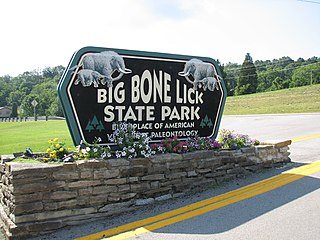
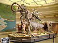
Big Bone Lick State Park is located at Big Bone in Boone County, Kentucky. The name of the park comes from the Pleistocene megafauna fossils found there. Mammoths are believed to have been drawn to this location by a salt lick deposited around the sulfur springs. Other animals including forms of bison, caribou, deer, elk, horse, mastodon, moose, musk ox, peccary, ground sloths, wolves, black bears, stag moose, saber-toothed cats, and possibly tapir also grazed the vegetation and salty earth around the springs that the animals relied on for their diet.

The Falls of the Ohio National Wildlife Conservation Area is a national, bi-state area on the Ohio River near Louisville, Kentucky in the United States, administered by the U.S. Army Corps of Engineers in partnership with Indiana Department of Natural Resources. Federal status was awarded in 1981. The falls were designated a National Natural Landmark in 1966.

George Rogers Clark was an American military officer and surveyor from Virginia who became the highest-ranking Patriot military officer on the northwestern frontier during the Revolutionary War. He served as leader of the Virginia militia in Kentucky throughout much of the war. He is best known for his captures of Kaskaskia in 1778 and Vincennes in 1779 during the Illinois campaign, which greatly weakened British influence in the Northwest Territory and earned Clark the nickname of "Conqueror of the Old Northwest". The British ceded the entire Northwest Territory to the United States in the 1783 Treaty of Paris.

Caesar Creek State Park is a public recreation area located in southwestern Ohio, five miles (8 km) east of Waynesville, in Warren, Clinton, and Greene counties. The park is leased by the State from the U.S. Army Corps of Engineers, who in the 1970s erected a dam on Caesar Creek to impound a 2,830-acre (1,150 ha) lake. The total park area, including the lake, is 7,530-acre (3,050 ha).

Portland is a neighborhood and former independent town northwest of downtown Louisville, Kentucky. It is situated along a bend of the Ohio River just below the Falls of the Ohio, where the river curves to the north and then to the south, thus placing Portland at the northern tip of urban Louisville. In its early days it was the largest of the six major settlements at the falls, the others being Shippingport and Louisville in Kentucky and New Albany, Clarksville, and Jeffersonville on the Indiana side. Its modern boundaries are the Ohio River along the northwest, north, and northeast, 10th Street at the far east, Market Street on the south, and the Shawnee Golf Course at the far west.

The history of Louisville, Kentucky spans nearly two-and-a-half centuries since its founding in the late 18th century. The geology of the Ohio River, with but a single series of rapids midway in its length from the confluence of the Monongahela and Allegheny rivers to its union with the Mississippi, made it inevitable that a town would grow on the site. The town of Louisville, Kentucky was chartered there in 1780. From its early days on the frontier, it quickly grew to be a major trading and distribution center in the mid-19th century and an important industrial city in the early 20th. The city declined in the mid-20th century, but by the late 20th, it was revitalized as a culturally-focused mid-sized American city.

Charlestown State Park is an Indiana state park on 5,100 acres (20.64 km2) in Clark County, Indiana, in the United States. The park is on the banks of the Ohio River, 1 mile (2 km) east of Charlestown. It was once part of the Indiana Army Ammunition Plant (INAAP), and was donated in separate parcels to the Indiana state government. In 1993, the state of Indiana was given 859 acres (3.48 km2), and in 1994 was given an additional 1,125 acres (4.55 km2). When the park opened in 1996, it encompassed 2,400 acres (9.7 km2). With an additional 2,600 acres (10.5 km2) given by the INAAP in 2004, the park has 5,100 acres (20.6 km2), making it the third largest state park in Indiana. The park attracts nearly 200,000 visitors annually.

Clifty Falls State Park is an Indiana state park on 1,416 acres (573 ha) in Jefferson County, Indiana in the United States. It is 46 miles (74 km) northeast of Louisville, Kentucky. The park attracts about 370,000 visitors annually.
As with most American cities, transportation in Louisville, Kentucky, is based primarily on automobiles. However, the city traces its foundation to the era where the river was the primary means of transportation, and railroads have been an important part of local industry for over a century. In more recent times Louisville has become a national hub for air cargo, creating over 20,000 local jobs. The city has also launched several initiatives to promote both utilitarian and recreational bicycling. In 2016 Walk Score ranked Louisville 43rd "most walkable" of 141 U.S. cities with a population greater than 200,000. In 2015, 11.7 percent of Louisville households were without a car, which decreased to 10.9 percent in 2016. The national average was 8.7 percent in 2016. Louisville averaged 1.61 cars per household in 2016, compared to a national average of 1.8 per household.

The Old Clarksville site is along the waterfront of Clarksville, Indiana, roughly between the Interpretive Center and Clark Homesite of Falls of the Ohio State Park. Officially its address is restricted by the National Register, as much of it is on private property where there is no public access to the Ohio River.

The Vincennes Trace was a major trackway running through what are now the American states of Kentucky, Indiana, and Illinois. Originally formed by millions of migrating bison, the Trace crossed the Ohio River near the Falls of the Ohio and continued northwest to the Wabash River, near present-day Vincennes, before it crossed to what became known as Illinois. This buffalo migration route, often 12 to 20 feet wide in places, was well known and used by American Indians. Later European traders and American settlers learned of it, and many used it as an early land route to travel west into Indiana and Illinois. It is considered the most important of the traces to the Illinois country.

The Devonian Jeffersonville Limestone is a mapped bedrock unit in Indiana and Kentucky. It is highly fossiliferous. The Vernon Fork Member contains Volcanic ash associated with the Tioga Bentonites.

Paleontology in Kentucky refers to paleontological research occurring within or conducted by people from the U.S. state of Kentucky.