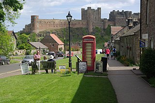
Bamburgh is a village and civil parish on the coast of Northumberland, England. It had a population of 454 in 2001, decreasing to 414 at the 2011 census.

St Mary's is the largest and most populous island of the Isles of Scilly, an archipelago off the southwest coast of Cornwall in England, United Kingdom.

Burnham-on-Sea is a seaside town in Somerset, England, at the mouth of the River Parrett, upon Bridgwater Bay. Burnham was a small fishing village until the late 18th century when it began to grow because of its popularity as a seaside resort.

Filey is a seaside town and civil parish in North Yorkshire, England. It is located between Scarborough and Bridlington on Filey Bay. Although it was a fishing village, it has a large beach and became a popular tourist resort. According to the 2011 UK census, Filey parish had a population of 6,981, in comparison to the 2001 UK census population figure of 6,819, and a population of 6,870 in 1991.
Bembridge is a village and civil parish located on the easternmost point of the Isle of Wight. It had a population of 3,848 according to the 2001 census of the United Kingdom, leading to the implausible claim by some residents that Bembridge is the largest village in England. Bembridge is home to many of the Island's wealthiest residents. The population had reduced to 3,688 at the 2011 Census.

Withernsea is a seaside resort town and civil parish in Holderness, East Riding of Yorkshire, England. Its white inland lighthouse, rising around 127 feet (39 m) above Hull Road, now houses a museum to 1950s actress Kay Kendall, who was born in the town.

Freshwater is a large village and civil parish at the western end of the Isle of Wight, England. The southern, coastal part of the village is Freshwater Bay, named for the adjacent small cove. Freshwater sits at the western end of the region known as the Back of the Wight or the West Wight, a popular tourist area.

Happisburgh is a village civil parish in the English county of Norfolk. The village is on the coast, to the east of a north–south road, the B1159 from Bacton on the coast to Stalham. It is a nucleated village. The nearest substantial town is North Walsham 6 miles (10 km) to the west.
St John the Evangelist's Church is in the village of Sandiway, Cheshire, England. It is an active Anglican parish church of Sandiway and Cuddington in the diocese of Chester, the archdeaconry of Chester and the deanery of Middlewich. The church is recorded in the National Heritage List for England as a designated Grade II listed building.

St John the Evangelist's Church is in Over, Winsford, Cheshire, England. The church is recorded in the National Heritage List for England as a designated Grade II listed building. It is an active Anglican parish church in the diocese of Chester, the archdeaconry of Chester and the deanery of Middlewich.

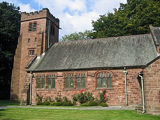
St John the Evangelist's Church is in the village of Gressingham, Lancashire, England. The church is recorded in the National Heritage List for England as a designated Grade I listed building. It is an active Anglican parish church in the deanery of Tunstall, the archdeaconry of Lancaster and the diocese of Blackburn. Its benefice is combined with those of St Margaret, Hornby, St John the Baptist, Arkholme, and St Michael the Archangel, Whittington-in-Lonsdale.

Croxton is a civil parish in North Lincolnshire, England. It is situated just south from the A180, 1 mile (1.6 km) north-west from Kirmington and 7 miles (11 km) west from Immingham.

Hailey is a village and civil parish about 2 miles (3 km) north of Witney, Oxfordshire. The village comprises three neighbourhoods: Middletown on the main road between Witney and Charlbury, Poffley End on the minor road to Ramsden and Delly End on Whiting's Lane. The parish extends from the River Windrush in the south, almost to the village of Ramsden and the hamlet of Wilcote in the north, and it includes the hamlet of New Yatt. The 2011 Census recorded the parish's population as 1,208.

St Michael's Church is located in the settlement of Whittington, Lancashire, England. It is an active Anglican parish church in the deanery of Tunstall, the archdeaconry of Lancaster and the diocese of Blackburn. Its benefice is united with those of St John the Evangelist, Gressingham, St Margaret, Hornby, and St John the Baptist, Arkholme. The church is recorded in the National Heritage List for England as a designated Grade II* listed building.

St John the Baptist's Church, is in the village of Arkholme, Lancaster, Lancashire, England. It is an active Anglican parish church in the deanery of Tunstall, the archdeaconry of Lancaster, and the diocese of Blackburn. Its benefice is united with those of St Margaret, Hornby, St John the Evangelist, Gressingham, and St Michael the Archangel, Whittington-in-Lonsdale. The church is recorded in the National Heritage List for England as a designated Grade II* listed building. It stands at the end of the village street, overlooking the River Lune, within the bailey of a former castle. The former 11th-century motte stands to the northeast of the church.

Lancashire is a county in North West England. In 1974 parts of the historic county were divided between Greater Manchester, Merseyside, Cheshire and Cumbria, and part of the West Riding of Yorkshire was transferred into the county, creating the non-metropolitan county of Lancashire. Together with the unitary authorities of Blackburn with Darwen and Blackpool it now forms the ceremonial county of Lancashire.

The Church of St John the Evangelist is a Church of England church in Upper Norwood, a suburb of South London, in the United Kingdom. It is a Grade II* listed red brick Gothic Revival church which was built between 1878 and 1887 by the English architect John Loughborough Pearson (1817–97). The church is dedicated to the Christian saint, John the Evangelist.
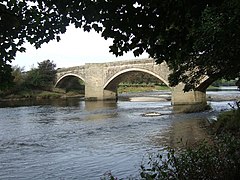
Gressingham is a civil parish in Lancaster, Lancashire, England. It contains 14 listed buildings that are recorded in the National Heritage List for England. Of these, one is listed at Grade I, the highest of the three grades, two are at Grade II*, the middle grade, and the others are at Grade II, the lowest grade. Apart from the village of Gressingham and the settlement of Eskrigge, the parish is rural. Almost all the listed buildings are houses and associated structures, farmhouses, and farm buildings. Also listed are a church and a bridge crossing the River Lune on the boundary of the parish.

Satterleigh and Warkleigh is a civil parish in North Devon district, Devon, England. In the 2011 census it was recorded as having a population of 170.