Carnforth is a market town and civil parish in the City of Lancaster in Lancashire, England, situated at the north-east end of Morecambe Bay. The parish of Carnforth had a population of 5,560 in the 2011 census, an increase from the 5,350 recorded in the 2001 census. The town is situated around 7 miles north of Lancaster, 17 miles south of Kendal, 40 miles east of Barrow-in-Furness and 28 miles north-west of Settle. The town is also close to the Cumbria/Lancashire border.
The City of Lancaster, or simply Lancaster, is a local government district with city status in Lancashire, England. It is named after its largest settlement, Lancaster, and also includes the towns of Carnforth, Heysham and Morecambe and a wider rural hinterland. The district has a population of 144,446 (2022), and an area of 219 square miles (567 km2).
Bolton-le-Sands is a large village and civil parish of the City of Lancaster in Lancashire, England. The parish had a population of 4,098 recorded in the 2001 census, increasing to 4,127 at the 2011 Census.

Silverdale is a village and civil parish within the City of Lancaster district of Lancashire, England. The village stands on Morecambe Bay, near the border with Cumbria, 4.5 miles (7 km) north west of Carnforth and 8.5 miles (14 km) of Lancaster. The parish had a population of 1,519 recorded in the 2011 census.

Yealand Conyers is a village in the civil parish of The Yealands, in the Lancaster district, in the county of Lancashire, England. In 2011 the former parish of Yealand Conyers had a population of 190.

Yealand Redmayne is a village in the civil parish of The Yealands, in the Lancaster district, in the county of Lancashire, England. In 2011 the former parish of Yealand Redmayne had a population of 326.

Warton is a village, civil parish and electoral ward in the Lancaster district of Lancashire, England. The village is close to the boundary with Cumbria, and approximately 1.5 miles (2.4 km) north of Carnforth, which was originally part of the parish of Warton. The village had a population of 2,315 at the 2001 census, and 2,360 at the 2011 census. The parish covers an area in excess of 11,000 acres (45 km2) and is predominantly rural.
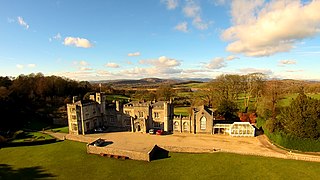
Leighton Hall is a historic house 0.5 miles (1 km) to the west of Yealand Conyers, Lancashire, England. It is recorded in the National Heritage List for England as a designated Grade II* listed building.

St Oswald's Church is in the village of Warton, Lancashire, England. It is an active Anglican parish church in the deanery of Tunstall, the archdeaconry of Lancaster, and the diocese of Blackburn. Its benefice is united with those of St Mary, Borwick and St John the Evangelist, Yealand Conyers. The church is recorded in the National Heritage List for England as a designated Grade II listed building. The ruined remains of the medieval rectory survive next to the present vicarage to the west of the church.
Yealand or Yealands may refer to:

St Mary's Church is in the village of Yealand Conyers, Lancashire, England. It is an active Roman Catholic church in the diocese of Lancaster, and is linked with the churches of St Mary of the Angels, Bolton-le-Sands, and Our Lady of Lourdes, Carnforth. The church is recorded in the National Heritage List for England as a designated Grade II listed building. It stands at the south end of the village.

St Mary's Church is located to the north of the village of Borwick, Lancashire, England. It is an active Anglican parish church in the deanery of Tunstall, the archdeaconry of Lancaster, and the diocese of Blackburn. Its benefice is united with those of St Oswald, Warton, and St John the Evangelist, Yealand Conyers. The church is recorded in the National Heritage List for England as a designated Grade II listed building.

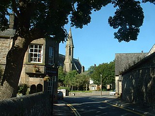
St John the Evangelist's Church is in Church Lane, Yealand Conyers, Lancashire, England. It is an active Anglican parish church in the diocese of Blackburn. The church was built in 1838, extended in 1861 and again in 1882. It is constructed mainly in limestone, and consists of a nave, a north aisle, a chancel and a west tower. Inside is a west gallery and stained glass by Shrigley and Hunt. The church holds services on Sundays and Wednesdays. It is recorded in the National Heritage List for England as a designated Grade II listed building.

Mourholme, Maurholme, Morhull or Merhull was a manor and castle in north Lancashire, England, in the present parish of Warton, north of Carnforth. The castle of "Merhull" was surrendered to King John in 1216 by Gilbert Fitz Reinfred. It is not known whether it was built of timber or of stone.
Lancaster Rural District was a rural district in the county of Lancashire, England. It was created in 1894 and abolished in 1974 under the Local Government Act 1972.

The Yealands is a civil parish in City of Lancaster district, Lancashire, England. It includes the villages of Yealand Conyers and Yealand Redmayne and the hamlet of Yealand Storrs. The parish was formed on 1 April 2024 by combining the former parishes of Yealand Conyers and Yealand Redmayne. It has a parish council, the lowest level of local government in England. In 2021 the parishes had a population of 539.
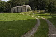
The Yealands is a civil parish in Lancaster, Lancashire, England. It was created in 2024 from the parishes of Yealand Conyers and Yealand Redmayne. It contains 43 buildings that are recorded in the National Heritage List for England as designated listed buildings. Of these, three are at Grade II*, the middle grade, and the others are at Grade II, the lowest grade. The civil parish contains the villages of Yealand Conyers and Yealand Redmayne, and is otherwise rural. Most of the listed buildings are houses, farmhouses and farm buildings, many of them on the main streets of the villages. The other listed buildings include a country house, two churches, and a Quaker Meeting House. The Lancaster Canal passes through the parish, and three bridges crossing it are listed, together with a milestone on its towpath.