Lancaster is a city in Lancashire, England and the main cultural hub, economic and commercial centre of City of Lancaster district. The city is on the River Lune and is directly inland from Morecambe Bay. Lancaster is the county town of Lancashire although Lancashire County Council has been based at County Hall in Preston since its formation in 1889.

Morecambe Bay is an estuary in northwest England, just to the south of the Lake District National Park. It is the largest expanse of intertidal mudflats and sand in the United Kingdom, covering a total area of 120 sq mi (310 km2). In 1974, the second largest gas field in the UK was discovered 25 mi (40 km) west of Blackpool, with original reserves of over 7 trillion cubic feet (tcf). At its peak, 15% of Britain's gas supply came from the bay but production is now in decline. Morecambe Bay is also an important wildlife site, with abundant birdlife and varied marine habitats.

The River Lune is a river 53 miles (85 km) in length in Cumbria and Lancashire, England.

The Lune Millennium Bridge is a cable-stayed footbridge which spans the River Lune in Lancaster, England.
Sharpness is an English port in Gloucestershire, one of the most inland in Britain, and eighth largest in the South West England region. It is on the River Severn at grid reference SO669027, at a point where the tidal range, though less than at Avonmouth downstream, is still large.

The Old Dock, originally known as Thomas Steers' dock, was the world's first commercial wet dock. The 3+1⁄2 acres (1.4 ha) dock was built on the River Mersey in Liverpool, England, starting in 1710 and completed in 1716. A natural tidal pool off the River Mersey, which probably gave its name to Liverpool centuries earlier, was partially filled and locked in from the river with quay walls erected.
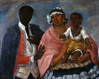
Sambo originally Zambo is a derogatory label for a person of African descent in the Spanish language. Historically, it is a name in American English derived from a Spanish term for a person of African and Native American ancestry. After the Civil War, during and after the Jim Crow era the term was used in conversation, print advertising and household items as a pejorative descriptor for black people. The term is now considered offensive in American and British English.

Morecambe and Lunesdale is a constituency represented in the House of Commons of the UK Parliament since 2010 by David Morris, a Conservative.
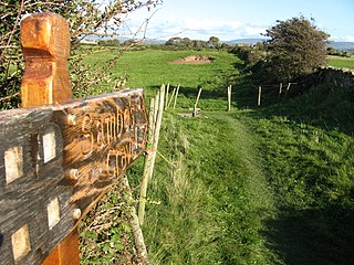
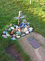
Sambo's Grave is the burial site of a black cabin boy or slave on unconsecrated ground in a field near the small village of Sunderland Point, Lancashire, England. Sunderland Point was a port, serving cotton, sugar and slave ships from the West Indies and North America, which declined after Glasson Dock was opened in 1787. It is a very small community only accessible via a narrow road, which crosses a salt marsh and is cut off at high tide.

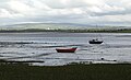
Overton is a village and civil parish in Lancashire, England, south west of Lancaster and south of Morecambe between Heysham and the estuary of the River Lune. Neighbouring villages include Middleton and Sunderland Point; Glasson is on the opposite side of the river. The parish had a population of 1,069 at the 2011 Census.

Thurnham is a civil parish in Lancashire, England. It is situated on the south side of the River Lune estuary in the City of Lancaster, and contains the villages of Conder Green, Glasson Dock, Lower Thurnham and Upper Thurnham. The parish has a population of 595, increasing to 651 at the 2011 census.

Glasson Dock, also known as Glasson, is a village in Lancashire, England, south of Lancaster at the mouth of the River Lune. In 2011, it had a population of around 600.

Christ Church is in the village of Glasson, Lancashire, England. It is an active Anglican parish church in the deanery of Lancaster and Morecambe, the archdeaconry of Lancaster, and the diocese of Blackburn. Its benefice is combined with those of St Michael, Cockerham, and St Luke, Winmarleigh. The church is recorded in the National Heritage List for England as a designated Grade II listed building.
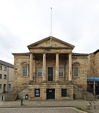
The Custom House is a grade II* listed building located on St Georges Quay, Lancaster, Lancashire, England. The architect was Richard Gillow of the Gillow furniture making family. Designed in 1764 for the Port Commissioners, it was used for its original purpose until 1882 when the Customs were transferred to Barrow-in-Furness.
Overton is a civil parish in Lancaster, Lancashire, England. It contains 29 buildings that are recorded in the National Heritage List for England as designated listed buildings. Of these, one is at Grade II*, the middle grade, and the others are at Grade II, the lowest grade.

Plover Scar Lighthouse, also known as the Abbey Lighthouse, is an active 19th century lighthouse sited at the entrance of the Lune estuary, near Cockersand Abbey in Lancashire, England. The lighthouse is maintained by the Lancaster Port Commission. It is registered under the international Admiralty number A4876 and has the NGA identifier of 114-5144.
The Glasson Dock Branch Line was a railway line in Lancashire, England. Opened in 1883, this 5-mile branch line connected Glasson Dock to the UK rail network at Lancaster, with stations at Glasson Dock, Conder Green and at a private halt, Ashton Hall railway station. Passenger and freight services were provided, and its success came from transporting goods from the dock at Glasson and from St Georges Quay in Lancaster.

The Bay Cycle Way is an 80-mile (130 km) cycling route around Morecambe Bay in Lancashire and Cumbria in north west England. Most of it forms National Cycle Route 700, while other sections are waymarked as NCN 6, NCN 69 and NCN 70.
Lancaster Port Commission is the statutory harbour authority for the Port of Lancaster. It is now based at Glasson Dock. It was set up by act of parliament to facilitate the role that the port could play in international trade, particularly the Atlantic slave trade. Many of the early commissioners were active slave traders.