Hlabisa Local Municipality

Last updated
Hlabisa
Hlabisa CoA.png
Map of KwaZulu-Natal with Hlabisa highlighted.svg
Location in KwaZulu-Natal
Country South Africa
Province KwaZulu-Natal
District uMkhanyakude
Seat Hlabisa
Wards 8
Government
[1]
  Type Municipal council
  MayorBhekinkosi Ntombela
Area
  Total1,555 km2 (600 sq mi)
Population
 (2011) [2]
  Total71,925
  Density46/km2 (120/sq mi)
Racial makeup (2011)
[2]
   Black African 99.4%
   Coloured 0.1%
   Indian/Asian 0.2%
   White 0.1%
First languages (2011)
[2]
   Zulu 95.0%
   Southern Ndebele 1.5%
   English 1.2%
  Other2.3%
Time zone UTC+2 (SAST)
Municipal codeKZN274

Hlabisa was an administrative area in the Umkhanyakude District of KwaZulu-Natal in South Africa. Hlabisa is an isiZulu surname of the two nkosis (kings) in the area. The municipality was situated within the vicinity of four Tribal Authorities which are the Mkhwanazi Tribal Authority, the Mdletshe Tribal Authority, and two Hlabisa Tribal Authorities. [3]

Contents

The municipality was generally characterised by isolated rural communities with high levels of poverty. The most significant land use was subsistence agriculture and dispersed settlements, plantations and agriculture are found throughout the municipality. The major draw card of Hlabisa was the tourism industry centred on the adjacent game reserve. [4]

After municipal elections on 3 August 2016 it was merged into the larger Big Five Hlabisa Local Municipality.

Main places

The 2001 census divided the municipality into the following main places: [5]

PlaceCodeArea (km2)Population
Abakwahlabisa 53501 133.6216,583
Hlabisa 53502 1.14652
Mdletshe 53503 375.1738,851
Mpembeni 53504 114.8310,490
Mpukunyoni 53505 796.90110,299

Politics

The municipal council consisted of sixteen members elected by mixed-member proportional representation. Eight councillors were elected by first-past-the-post voting in eight wards, while the remaining eight were chosen from party lists so that the total number of party representatives was proportional to the number of votes received. In the election of 18 May 2011 no party obtained a majority. The following table shows the results of the election. [6] [7]

The National Freedom Party lost a ward to the Inkatha Freedom Party in a by-election in December 2012. As a result, the IFP gained a majority of 9 seats on the council. [8]

PartyVotesSeats
WardListTotal %WardListTotal
IFP 8,5738,50217,07546.8628
ANC 5,0525,07610,12827.8134
NFP 4,5594,5619,12025.0134
Democratic Alliance 35901250.3000
Total18,21918,22936,448100.08816
Spoilt votes329318647

Related Research Articles

Inkatha Freedom Party Political party in South Africa

The Inkatha Freedom Party is a political party in South Africa. The party has been led by Velenkosini Hlabisa since the party's 2019 National General Conference. Mangosuthu Buthelezi founded the party in 1975 and led it until 2019. The IFP is currently the fourth largest party in the National Assembly of South Africa, in 2014 yielding third place to the Economic Freedom Fighters, formed in 2013. Although registered as a national party, it has had only minor electoral success outside its home province of KwaZulu-Natal.

Hibiscus Coast Local Municipality Former local municipality in KwaZulu-Natal, South Africa

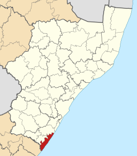
Hibiscus Coast Local Municipality was a local municipality in the province of KwaZulu-Natal in South Africa. It governed the Hibiscus Coast on the KwaZulu-Natal South Coast which attracts tourists from the province and other provinces as well as international tourists.

Abaqulusi Local Municipality Local municipality in KwaZulu-Natal, South Africa

AbaQulusi Local Municipality is a local municipality in Zululand in the KwaZulu-Natal province of South Africa. It is named after the AbaQulusi, a Zulu clan whose descendants live in the vicinities of Vryheid, Utrecht, eDumbe and eNgoje. They hailed from different origins but were unified by their allegiance to local Zulu royal homesteads. Historically they were not drafted into ordinary "amabutho" regiments but rather into a royal section, and no "umnumzane" chief presented them in the Zulu king's council.

Nkandla Local Municipality Local municipality in KwaZulu-Natal, South Africa

Nkandla Local Municipality is an administrative area in the King Cetshwayo District of KwaZulu-Natal province in South Africa. The town of Nkandla is the home town of the former President of South Africa, Jacob Zuma.

Endumeni Local Municipality Local municipality in KwaZulu-Natal, South Africa

Endumeni Local Municipality is an administrative area in the Umzinyathi District of KwaZulu-Natal in South Africa. Endumeni is an isiZulu name meaning "a place of thunderstorm". The municipality shares its name with the Endumeni hill.

Indaka Local Municipality Local municipality in KwaZulu-Natal, South Africa

Indaka Local Municipality was an administrative area in the Uthukela District of KwaZulu-Natal in South Africa. The municipality is named after the Indaka River that runs through the municipal area.

Maphumulo Local Municipality Local municipality in KwaZulu-Natal, South Africa

Maphumulo Local Municipality is an administrative area in the iLembe District of KwaZulu-Natal in South Africa. Maphumulo is an isiZulu name meaning "place of rest".

eMadlangeni Local Municipality Local municipality in KwaZulu-Natal, South Africa

eMadlangeni Local Municipality, previously known as Utrecht Local Municipality, is an administrative area in the Amajuba District of KwaZulu-Natal in South Africa.

Msinga Local Municipality Local municipality in KwaZulu-Natal, South Africa

Msinga Local Municipality is an administrative area in the Umzinyathi District of KwaZulu-Natal in South Africa. The name means a current in the sea where air movement causes ripples on top of the water surface and ends up influencing the nearby climatic conditions through its breeze.

Mtubatuba Local Municipality Local municipality in KwaZulu-Natal, South Africa

Mtubatuba is an administrative area in the Umkhanyakude District of KwaZulu-Natal in South Africa.

Jozini Local Municipality Local municipality in KwaZulu-Natal, South Africa

Jozini is an administrative area in the Umkhanyakude District of KwaZulu-Natal in South Africa. Significant portions of Jozini have been neglected in terms of economic development. There is a great disparity between the level of service and infrastructure provision between settlement nodes, such as the towns of Mkuze and Jozini, and the surrounding rural areas. Most of the rural area is associated with a lack of development, poverty and poor service provision.

eDumbe Local Municipality Local municipality in KwaZulu-Natal, South Africa

eDumbe Local Municipality is an administrative area in the Zululand District of KwaZulu-Natal in South Africa. The municipality is named after the Dumbe mountain.

uMlalazi Local Municipality Local municipality in KwaZulu-Natal, South Africa

uMlalazi Local Municipality is an administrative area in the King Cetshwayo District of KwaZulu-Natal in South Africa. The municipality is named after the uMlalazi River.

Ezinqoleni Local Municipality Former local municipality in KwaZulu-Natal, South Africa

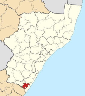
Ezinqoleni Local Municipality was an administrative area in the Ugu District of KwaZulu-Natal in South Africa.

Nquthu Local Municipality Local municipality in KwaZulu-Natal, South Africa

Nquthu Local Municipality is an administrative area in the Umzinyathi District of KwaZulu-Natal in South Africa. Nquthu is an isiZulu name meaning "the back of the head".

Umtshezi Local Municipality Local municipality in KwaZulu-Natal, South Africa

Umtshezi Local Municipality was an administrative area in the Uthukela District of KwaZulu-Natal in South Africa. uMtshezi is an isiZulu name word for Bushman or San. The name uMtshezi refers to the Bushman River. After municipal elections on 3 August 2016 it was merged into the larger Inkosi Langalibalele Local Municipality.

Mthonjaneni Local Municipality Local municipality in KwaZulu-Natal, South Africa

Mthonjaneni is an administrative area in the King Cetshwayo District of KwaZulu-Natal in South Africa.

Ntambanana Local Municipality Local municipality in KwaZulu-Natal, South Africa

Ntambanana Local Municipality was a local municipality within the uThungulu District of KwaZulu-Natal in South Africa. In 2016 the municipality was dissolved and its territory divided between Mthonjaneni Local Municipality, uMhlathuze Local Municipality and uMfolozi Local Municipality.

Mandeni Local Municipality Local municipality in KwaZulu-Natal, South Africa

Mandeni Local Municipality is an administrative area in the iLembe District of KwaZulu-Natal in South Africa.

uMfolozi Local Municipality Local municipality in KwaZulu-Natal, South Africa

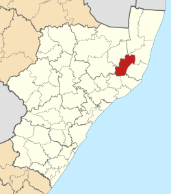
uMfolozi Local Municipality is a local municipality within the King Cetshwayo District Municipality of KwaZulu-Natal in South Africa. It is situated around the town of KwaMbonambi, to the north of Richard's Bay, stretching from the Indian Ocean to the edge of the Hluhluwe–Imfolozi Park.

References

  1. "Contact list: Executive Mayors". Government Communication & Information System. Archived from the original on 14 July 2010. Retrieved 22 February 2012.
  2. 1 2 3 "Statistics by place". Statistics South Africa. Retrieved 27 September 2015.
  3. South African Languages - Place names
  4. "KwaZulu-Natal Top Business - Hlabisa Municipality". Archived from the original on 2011-08-19. Retrieved 2010-12-29.
  5. Lookup Tables - Statistics South Africa [ permanent dead link ]
  6. "Results Summary – All Ballots: Hlabisa" (PDF). Independent Electoral Commission. Retrieved 3 December 2013.
  7. "Seat Calculation Detail: Hlabisa" (PDF). Independent Electoral Commission. Retrieved 3 December 2013.
  8. "IFP wins Jacob Zuma's Nkandla ward from ANC - Blessed Gwala - POLITICS | Politicsweb".

Coordinates: 28°08′S31°52′E / 28.133°S 31.867°E / -28.133; 31.867