
Yukon–Koyukuk Census Area is a census area in the U.S. state of Alaska. As of the 2010 census, the population was 5,588. It has the largest area of any county or county-equivalent in the United States. It is part of the unorganized borough of Alaska and therefore has no borough seat. Its largest communities are the cities of Galena, in the west, and Fort Yukon, in the northeast.
The Sacramento National Wildlife Refuge Complex is part of the United States system of National Wildlife Refuges (NWR). It is located in northern California, in the valley of the Sacramento River.

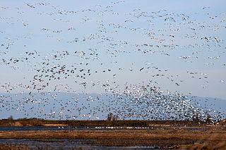
The Ruby Lake National Wildlife Refuge is located in southwestern Elko County and northwestern White Pine County in the northeastern section of the state of Nevada in the western United States. Established in 1938, it encompasses 37,632 acres (152.29 km2) of wetlands in Ruby Valley, just east of the Ruby Mountains and just south of Harrison Pass. It is 16 miles (26 km) long, up to 3 miles (4.8 km) in width, and lies at an elevation of 6,000 feet (1,800 m). Once the bed of a 200-foot (61 m) deep lake, it is now a network of spring-fed marshes and shallow ponds serving as a habitat for hundreds of species of native and migratory birds and mammals.

Selawik National Wildlife Refuge in northwest Alaska in the Waring Mountains was officially established in 1980 with the passage of the Alaska National Interest Lands Conservation Act (ANILCA).

Benton Lake National Wildlife Refuge is a 12,459-acre (5,042 ha) National Wildlife Refuge (NWR) in the central part of the U.S. state of Montana. It lies in northern Cascade County, 12 mi (19 km) north of the city of Great Falls, Montana. Benton Lake NWR includes shortgrass prairie and seasonal wetlands, and is nearly surrounded by the Highwood Mountains to the east, Big Belt Mountains to the south, and the Rocky Mountains to the west. Benton Lake NWR is on the western edge of the northern Great Plains and much of the shallow lake is a 6,000-acre (2,400 ha) wetland.
The Mark Twain National Wildlife Refuge Complex was established for the protection of migratory birds including waterfowl, shorebirds, and songbirds. It is located along the Mississippi Flyway, one of the major routes for migrating waterfowl. Refuge units also provide important habitat for big-river fish and a variety of other native wildlife such as deer, fox, beaver, frogs, turtles, and snakes. Key goals are to conserve and enhance the quality and diversity of fish and wildlife and their habitats, to restore floodplain functions in the river corridor, and to provide wildlife-related recreational experiences for the public.

Baskett Slough National Wildlife Refuge is located in northwestern Oregon, 10 miles (16 km) west of Salem in Polk County. Situated in open farmland near the eastern foothills of the Oregon Coast Range with the broad Willamette Valley and the Cascade Range to the east, elevations range from 185 to 414 feet MSL. The Willamette Valley, with its mild, rainy winter climate, is an ideal environment for wintering waterfowl. The valley was once a rich mix of wildlife habitats with extensive wetlands, meandering stream channels and vast seasonal marshes. Today, the valley is a mix of farmland and growing cities, with few areas remaining for wildlife. The Refuge consists of 1,173 acres (4.75 km²) of cropland, which provide forage for wintering geese, 300 acres (1.2 km²) of forests, 550 acres (2.2 km²) of grasslands, and 500 acres (2.0 km²) of shallow water seasonal wetlands and 35 acres (0.14 km²) of permanent open water. In 1965, Baskett Slough National Wildlife Refuge was created to help ensure some of the original habitat remained for species preservation. The refuge is managed by the U.S. Fish and Wildlife Service, an agency of the U.S. Department of the Interior.

The Sespe Condor Sanctuary is a 53,000-acre (210 km2) wildlife refuge in the Topatopa Mountains, in northeastern Ventura County, California. It is within the Sespe Wilderness in the southern Los Padres National Forest.

The Blackbeard Island National Wildlife Refuge is a 5,618 acre National Wildlife Refuge located in McIntosh county in Georgia. The refuge was established to provide a nature and forest preserve for aesthetic and conservation purposes.

The Columbia Plateau Trail is a 130-mile-long (210 km), 20-foot-wide (6.1 m) corridor in eastern Washington state maintained as part of the Washington State Park system. The trail runs along the abandoned right-of-way of the former Spokane, Portland and Seattle Railway from Cheney to the confluence of the Snake and Columbia rivers at Pasco, Washington, passing through five counties in the southeastern part of the state. The trail's recreational uses include hiking, mountain biking, horseback riding, in-line skating on paved portions, and wildlife viewing.
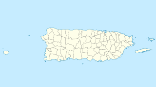
Cabo Rojo National Wildlife Refuge is located on the southwestern side of Puerto Rico in the municipio of Cabo Rojo. It was established in 1974, when 587 acres of land were obtained by the U.S. Fish and Wildlife Service from the Central Intelligence Agency which had operated the Caribbean Bureau of the Foreign Broadcast Information Service there for a number of years. The 1,836 acres (7.43 km2) refuge is a habitat for number of native bird species including the endangered yellow-shouldered blackbird also known as la mariquita de Puerto Rico or capitán. Many birds find their way to the refuge while migrating between North and South America.
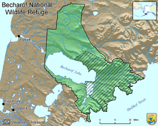
Becharof National Wildlife Refuge is a National Wildlife Refuge in the Aleutian Range of the Alaska Peninsula of southwestern Alaska. It is adjacent to Katmai National Park and Preserve. This national wildlife refuge, which covers an area of 1,200,000 acres (4,900 km2), was established in 1980 to conserve major brown bears, salmon, migratory birds, caribou, marine birds, and mammals and to comply with treaty obligations. It lies primarily in the east-central part of Lake and Peninsula Borough, but extends eastward into the mainland portion of Kodiak Island Borough. The refuge is administered from offices in King Salmon.

The Sayville National Wildlife Refuge is a 127-acre (51 ha) National Wildlife Refuge (NWR) located in West Sayville, New York about two miles (3.2 km) inland from the Great South Bay. Sayville NWR is managed by the U.S. Fish and Wildlife Service as a sub-unit of Wertheim National Wildlife Refuge and part of the Long Island National Wildlife Refuge Complex. It is the only land-locked refuge in the complex.

San Diego National Wildlife Refuge is a National Wildlife Refuge in California. It is part of the San Diego National Wildlife Refuge Complex.
Mid-Columbia River National Wildlife Refuge Complex is a group of protected areas in the U.S. states of Oregon and Washington. Headquartered in Burbank, Washington, its administrators manage seven national wildlife refuges (NWR)s and one national monument on or near the Columbia River. They are Cold Springs, Columbia, Conboy Lake, McKay Creek, McNary, Toppenish and Umatilla NWRs and Hanford Reach National Monument.
The Mattamuskeet, Swanquarter and Cedar Island National Wildlife Refuge Complex is an administrative organization that manages U.S. Fish and Wildlife Service wildlife refuges in eastern North Carolina. The complex includes


