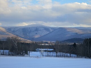
Mount Greylock in northwest Massachusetts is the highest point in the state at 3,489 feet. The peak played a role in early American literature, and is part of the Taconic Mountains, which are geologically distinct from the nearby Berkshires and Green Mountains. Expansive views and a small area of sub-alpine forest characterize its upper reaches. A seasonal automobile road crosses the summit area, passing near its three structures from the 1930s which together constitute a small, "National Historic District." Various hiking paths including the Appalachian Trail traverse the area, which is part of the larger Mount Greylock State Reservation.

Middlesex Fells Reservation, often referred to simply as the Fells, is a public recreation area covering more than 2,200 acres (890 ha) in Malden, Medford, Melrose, Stoneham, and Winchester, Massachusetts. The state park surrounds two inactive reservoirs, Spot Pond and the Fells Reservoir, and the three active reservoirs that are part of the water supply system for the town of Winchester. Spot Pond and the Fells Reservoir are part of the Wachusett water system, one of six primary water systems that feed metropolitan Boston's waterworks. The park is managed by the Massachusetts Department of Conservation and Recreation and is part of the Metropolitan Park System of Greater Boston.

Mount Greylock State Reservation is public recreation and nature preservation area on and around Mount Greylock, the highest point in the U.S. state of Massachusetts. The park covers some 12,000 acres (4,900 ha) in the towns of Lanesborough, North Adams, Adams, Cheshire, Williamstown and New Ashford, Massachusetts. It was created in 1898 as Massachusetts' first public land for the purpose of forest preservation.

Mount Washington State Forest is a 4,619-acre (1,869 ha) state forest in the Mount Washington, Massachusetts. The forest conjoins with New York state and the state of Connecticut in the southern Taconic Mountains of the southwestern Berkshire region of Massachusetts. In addition to offering recreational and scenic opportunities, the forest lies adjacent to Bash Bish Falls State Park. It is managed by the Massachusetts Department of Conservation and Recreation.

Douglas State Forest is a publicly owned forest with recreational features located in the town of Douglas, Massachusetts, bordering both Connecticut and Rhode Island. The state forest's 5,525 acres (2,236 ha) include Wallum Lake and a rare Atlantic white cedar swamp, 5 acres (2.0 ha) of which are designated as a Massachusetts Wildland. The forest is managed by the Massachusetts Department of Conservation and Recreation.

Brimfield State Forest is a Massachusetts state forest located in and around the town of Brimfield in Hampden County, Massachusetts. The forest includes Dean Pond Recreation Area, a popular spot for fishing, picnicking and swimming. The park is managed by the Department of Conservation and Recreation.

Mount Everett State Reservation is a public recreation area in the towns of Mount Washington and Sheffield, Massachusetts, that offers panoramic views of Massachusetts, Connecticut, and New York from the summit of 2,624-foot (800 m) Mount Everett. The reservation abuts Jug End State Reservation and Wildlife Management Area; Bash Bish Falls State Park and Mount Washington State Forest lie to the west. All are managed by the Massachusetts Department of Conservation and Recreation.
Mount Grace State Forest is a publicly owned forest with recreational features located in the town of Warwick. The state forest centers around Mount Grace, which at 1,621 feet (494 m) is the third highest point in Massachusetts east of the Connecticut River after Mount Wachusett and Mount Watatic. It is bordered by portions of Warwick State Forest to the east and west and is managed by the Massachusetts Department of Conservation and Recreation.

Leominster State Forest is a publicly owned forest with recreational features covering 4,246 acres (1,718 ha) in the Massachusetts towns of Leominster, Fitchburg, Princeton, Sterling, and Westminster. The state forest encompasses an extensive trail system, numerous small ponds, and the Crow Hills. Plants such as mountain laurel are common as is an abundance of wildlife. The forest is headquarters for Massachusetts Bureau of Forest Fire Control District 8 and is managed by the Department of Conservation and Recreation.

Mount Sugarloaf State Reservation is a state-owned, public recreation area managed by the Massachusetts Department of Conservation and Recreation located in South Deerfield, just west of the Connecticut River. The state park includes the summits of North Sugarloaf Mountain and South Sugarloaf Mountain, as well as 1.75 miles of frontage on the Connecticut River and two river islands. The park is part of a larger park designation called the Connecticut River Greenway State Park. Portions of the park property along the river are used by the University of Massachusetts Amherst for agricultural research.

Mount Holyoke Range State Park is a state-owned, public recreation area encompassing the eastern half of the Holyoke Range in the Pioneer Valley region of Massachusetts. The state park is adjacent to J. A. Skinner State Park, which occupies the western half of the Holyoke Range. Both are managed by the Massachusetts Department of Conservation and Recreation.

Mount Tom State Reservation encompasses the Mount Tom Range and is located in the Connecticut River Valley region of Massachusetts, just north of the city of Springfield. The reservation is noted for its biologic diversity, high cliffs, and rugged scenery.

Squantum Point Park is a state-owned, public recreation area located on the Squantum peninsula of Quincy, Massachusetts, United States. The park was created on the site of the former Squantum Naval Air Station, which is preserved in a 2,700-foot-long (820 m) strip of runway, and the former dockworks of the Bethlehem Shipbuilding Corporation. The park is managed by the Massachusetts Department of Conservation and Recreation and is associated with the development of the Neponset River Reservation.

Spencer State Forest is a Massachusetts state forest and recreation reserve located in the town of Spencer, managed by the Massachusetts Department of Conservation and Recreation. The 92 mile (148 km) Midstate Trail passes through the state forest. The Commonwealth of Massachusetts also conducts logging in some parts of the property.
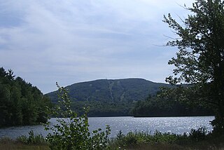
Wachusett Mountain State Reservation is a protected area encompassing 3,000 acres (1,200 ha) around the summit of Mount Wachusett in Massachusetts.
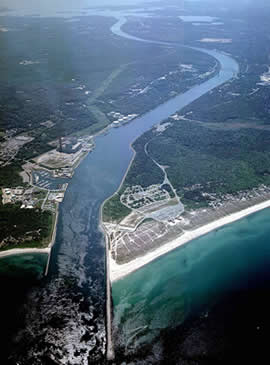
Scusset Beach State Reservation is a state-operated, public recreation area located in the town of Sandwich in Barnstable County, Massachusetts, at the east end of the Cape Cod Canal on land formerly part of Sagamore Hill Military Reservation. In addition to its beach and campgrounds, prominent features of the park include Sagamore Hill, a one-time Native American meeting ground and site of World War II coastal fortifications, and a 3,000-foot (910 m) stone jetty that separates the canal and beach. Unlike most of Sandwich, this section of the town is on the mainland side of the Cape Cod Canal. The state park is managed by the Massachusetts Department of Conservation and Recreation under a lease agreement with the U.S. Army Corps of Engineers.

Tolland State Forest is a publicly owned forest with recreational features covering 4,415 acres (1,787 ha) in the towns of Otis, Tolland, Blandford and Sandisfield in the southern Berkshire Hills of Massachusetts. The state forest centers on the 1,065-acre (431 ha) Otis Reservoir, the largest body of water for recreational use in western Massachusetts. The forest is managed by the Department of Conservation and Recreation.

Federated Women's Club State Forest is a Massachusetts state forest located in the towns of Petersham and New Salem. Notable forest scenery is found along wooded roads with views of Fever Brook, which has been dammed and provides a stopover for migrating birds. The forest's most prominent geological feature, "The Gorge," is found in the southwest part of the property. The forest is managed by the Department of Conservation and Recreation (DCR).
Kenneth Dubuque Memorial State Forest is a Massachusetts state forest in the northern Berkshire Hills in the towns of Hawley, Plainfield, and Savoy. The forest is managed by the Department of Conservation and Recreation (DCR). In 1985, the forest was named in memory of Kenneth M. Dubuque, a former employee of the Department of Environmental Management.
Lowell-Dracut-Tyngsboro State Forest is a publicly owned forest with recreational features measuring 1,109 acres (449 ha) that overlap the City of Lowell, and the towns of Dracut and Tyngsborough, Massachusetts. The forest, which includes some 180 acres (73 ha) of ponds, swamps and wetlands, is maintained by the Massachusetts Department of Conservation and Recreation.


