
North Adams is a city in Berkshire County, Massachusetts, United States. It is part of the Pittsfield, Massachusetts Metropolitan Statistical Area. Its population was 12,961 as of the 2020 census. Best known as the home of the largest contemporary art museum in the United States, the Massachusetts Museum of Contemporary Art, North Adams has in recent years become a center for tourism, culture and recreation.

Charlemont is a town in Franklin County, Massachusetts, United States. The population was 1,185 at the 2020 census. It is part of the Springfield, Massachusetts Metropolitan Statistical Area.
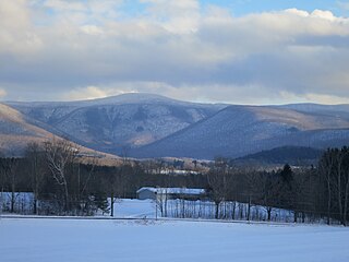
Mount Greylock is a 3,489-foot (1,063-meter) mountain located in the northwest corner of Massachusetts and is the highest point in the state. Its summit is in the western part of the town of Adams in Berkshire County. Technically, Mount Greylock is geologically part of the Taconic Mountains, which are not associated with the abutting Berkshire Mountains to the east. The mountain is known for its expansive views encompassing five states and the only taiga-boreal forest in the state. A seasonal automobile road climbs to the summit, topped by a 93-foot-high (28 m) lighthouse-like Massachusetts Veterans War Memorial Tower. A network of hiking trails traverses the mountain, including the Appalachian Trail. Mount Greylock State Reservation was created in 1898 as Massachusetts' first public land for the purpose of forest preservation.

Adams is a town in northern Berkshire County, Massachusetts, United States. It is part of the Pittsfield, Massachusetts Metropolitan Statistical Area. The population was 8,166 at the 2020 census.

The Hoosac Tunnel is a 4.75-mile (7.64 km) active railroad tunnel in western Massachusetts that passes through the Hoosac Range, an extension of Vermont's Green Mountains. It runs in a straight line from its east portal, along the Deerfield River in the town of Florida, to its west portal in the city of North Adams.

The Ashuwillticook Rail Trail is a rail trail built on a former railroad corridor that runs parallel to Route 8 through the towns of Cheshire, Lanesborough and Adams, Massachusetts and is used for biking, walking, roller-blading, and jogging. The trail is managed by the Massachusetts Department of Conservation and Recreation (DCR). Its first two phases opened in 2001 and 2004, with a 1.2-mile northerly extension added in 2017. A 1.5 miles (2.4 km) extension is being built South from the old Berkshire Mall to Crane Ave. It is expected to open in the spring of 2022.

Pan Am Railways, Inc. (PAR) is an American holding company that owns and operates Class II regional railroads covering northern New England from Mattawamkeag, Maine, to Rotterdam Junction, New York. The primary subsidiaries of Pan Am Railways are Boston and Maine Corporation, Maine Central Railroad Company, Portland Terminal Company, and Springfield Terminal Railway Company. The company is owned by Portsmouth, New Hampshire-based Pan Am Systems.

The Troy and Greenfield Railroad, chartered in 1848, ran from Greenfield, Massachusetts, United States, to the Vermont state line. It was leased to the Troy and Boston Railroad in 1856, then consolidated into Fitchburg Railroad 1887 which in turn was acquired by Boston and Maine Railroad by lease in 1900.

The Grand Junction Railroad is an 8.55-mile (13.76 km) long railroad in the Boston, Massachusetts, area, connecting the railroads heading west and north from Boston. Most of it is still in use, carrying scrap either inbound or outbound to the Schnitzer scrap yard on the Everett waterfront or freight to the Chelsea Produce Market, and non-revenue transfers of Amtrak and MBTA passenger equipment between the lines terminating at North Station and South Station. The line is also notable for its railroad bridge over the Charles River that passes under the Boston University Bridge between Boston and Cambridge, Massachusetts.

The Fitchburg Railroad is a former railroad company, which built a railroad line across northern Massachusetts, United States, leading to and through the Hoosac Tunnel. The Fitchburg was leased to the Boston and Maine Railroad in 1900. The main line from Boston to Fitchburg is now operated as the MBTA Fitchburg Line; Pan Am Railways runs freight service on some other portions.

Iron Horse State Park, part of the Washington State Park System, is a 1,612-acre (7 km2) state park located in the Cascade Mountains and Yakima River Valley, between Cedar Falls on the west and the Columbia River on the east.

Savoy, Mountain State Forest is a remote Massachusetts state forest located primarily in the towns of Savoy and Florida, with portions extending into neighboring Adams and North Adams. Situated along the Hoosac Mountain Range, it features four ponds, and seven hill and mountain summits, including Lewis Hill (2177 ft), Flat Rock Hill (2195 ft), Spruce Hill (2566 ft), and Borden Mountain (2505 ft). Also within the forest are at least two notable waterfalls, Parker Brook Falls and Tannery Falls, the latter of which is a 100-foot (30 m) drop. The forest is managed by the Department of Conservation and Recreation.
The Blackstone River and Canal Heritage State Park is a part of the state park system of the Commonwealth of Massachusetts, managed by the Massachusetts Department of Conservation and Recreation (DCR). This 1,000-acre (4.0 km2) park "recalls the role of canals in transporting raw materials and manufactured goods between emerging industrial centers." The Blackstone River and Canal Heritage State Park at Uxbridge, Massachusetts, is the midpoint of the Blackstone River Valley National Heritage Corridor of the National Park System. The Blackstone River and Valley is where the industrial revolution was born in America. The southern entrance to this state park is the site of the historic Stanley Woolen Mill, currently being redeveloped for commercial and tourism. The Native American Nipmuc name for the village here was "Wacentug", translated as "bend in the river".

Cutler Park is a state-owned nature preserve and public recreation area that lies between Route 128/I-95 and the Charles River in Needham, Massachusetts. The state park's 739 acres (299 ha) contain the largest remaining freshwater marsh on the middle Charles River. Parts of its major trail run directly through the marsh via boardwalks; over 100 species of birds have been sighted here. The park is part of a plan by the Town of Needham to connect 18 public areas by 35 proposed trails. It is managed by the Massachusetts Department of Conservation and Recreation.

The Selkirk Hurdle is the term used by urban planners, railroad employees, politicians, and others to describe the route that must be taken by freight trains traveling between New York City and other points in downstate New York that are east of the Hudson River, and locations in the United States to the south and west. There are no rail freight bridges or tunnels that cross the Hudson River south of Selkirk, which is 10 miles (16 km) south of Albany and the home of Selkirk Yard, a major CSX classification yard. As a result, trains from Long Island and New York City must travel 140 miles (230 km) north to cross at Selkirk before continuing on their way. Advocates claim that this detour and the inefficiencies that result force New York City to rely more heavily on relatively-inefficient trucks than most parts of the United States, where freight trains are more common. However, at least for traffic to and from the west, this route was touted for its efficiency as the "Water Level Route" by the New York Central Railroad because trains using it did not have to climb over the Appalachian Mountains, and it is still used by the New York Central's successor, CSX, for traffic to both sides of the Hudson River.

The Hoosac Stores is a historic warehouse at 115 Constitution Road in Charlestown, Massachusetts. Originally designated Hoosac Stores 1 & 2, it is a six-story load-bearing brick warehouse, set just outside the gate of the Boston Navy Yard. A second, adjacent warehouse, identified as Hoosac Stores 3, was demolished in 2000 because it was structurally unsound.

The Springfield Terminal railroad bridge in Deerfield, Massachusetts, is a three-span deck-truss bridge which crosses the Connecticut River.

Williamstown Rail Yard and Station Historic District is a historic district at the junction of Cole Avenue and N. Hoosac Road in Williamstown, Massachusetts.The rail yard was an important junction point for the railroads of the area in the late 19th century, serving as the western terminus for trains passing through the Hoosac Tunnel to points east. The yard's facilities included a locomotive repair shop and a railroad roundhouse, although the latter has not survived. The district was listed the National Register of Historic Places in 1994.

The Pittsfield and North Adams Railroad was a railroad based in northwestern Massachusetts. It was chartered in 1842 and was purchased by the Western Railroad of Massachusetts before construction was finished in 1846, then acquired by the Boston and Albany Railroad in 1870, only to face a gradual demise between the 1960s and 1990. It ran 18.539 mi (29.836 km) from North Adams Junction in Pittsfield to North Adams, where it connected to the Troy and Greenfield Railroad, an affiliate of the Fitchburg Railroad.

Union Station was the main passenger railroad station of Troy, New York until it went out of service in 1958. A Beaux-Arts building, designed by Reed & Stem and completed ca. 1903, it served the New York Central Railroad (NYC), the Boston and Maine Railroad (B&M) and the Delaware and Hudson Railroad (D&H). This was the fourth union station in Troy. The tracks approaching the station were but feet away from homes.


