
Missisquoi National Wildlife Refuge is a National Wildlife Refuge located in the eastern shore of Lake Champlain in the U.S. state of Vermont. The refuge is in Franklin County in the northwest corner of the state near the International Boundary with Canada. It is the only National Wildlife Refuge located entirely in Vermont, and is administered by the United States Fish and Wildlife Service.

Desecheo is a small uninhabited island of the archipelago of Puerto Rico located in the northeast of the Mona Passage; 13 mi (21 km) from Rincón on the west coast of the main island of Puerto Rico and 31 mi (50 km) northeast of Mona Island. It has a land area of 0.589 sq mi. Politically, the island is administered by the U.S. Department of the Interior, U.S. Fish and Wildlife Service as the Desecheo National Wildlife Refuge, but part of Barrio Sabanetas of Mayaguez.
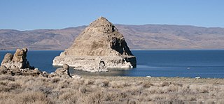
The Anaho Island National Wildlife Refuge is a wildlife refuge on Anaho Island in Pyramid Lake, Nevada. The refuge was established by President Woodrow Wilson in 1913 as a sanctuary for colonial nesting birds. It is home to one of the two largest colonies of pelicans—American white pelicans—in the western U.S. Other birds found on the island include California gulls, Caspian terns, double-crested cormorants, great blue herons, black-crowned night herons, and snowy egrets.
The Stewart B. McKinney National Wildlife Refuge is a 950-acre (384.5 ha) National Wildlife Refuge in ten units across the U.S. state of Connecticut. Located in the Atlantic Flyway, the refuge spans 70 miles (110 km) of Connecticut coastline and provides important resting, feeding, and nesting habitat for many species of wading birds, shorebirds, songbirds and terns, including the endangered roseate tern. Adjacent waters serve as wintering habitat for brant, scoters, American black duck, and other waterfowl. Overall, the refuge encompasses over 900 acres (364.2 ha) of barrier beach, intertidal wetland and fragile island habitats.
The Passage Key National Wildlife Refuge is part of the United States National Wildlife Refuge (NWR) System, located offshore from St. Petersburg. The 64-acre (0.26 km2) refuge was established in 1905 by President Theodore Roosevelt to preserve nesting colonies of native seabirds and wading birds. The Passage Key Wilderness Area is part of the refuge, and consists of 36.37 acres (0.1472 km2) of its total area. It was established in 1970, to protect native birds and serve as a breeding ground for them.

Protection Island is an island located in the Strait of Juan de Fuca just north of Discovery Bay in northeastern Jefferson County, Washington, United States. The island has a land area of 379 acres (153 ha). It is a federally protected National Wildlife Refuge; boats are not permitted within 200 yards (180 m) for the safety and health of wildlife on and near the shores. There is only one individual still living on the island not associated with the government. Marty Bluewater has lifetime use of his inholding cabin on the island's southern bluffs. The island also houses a caretaker, a volunteer hired by the United States Fish and Wildlife Service, to watch over the island and take care of its many inhabitants. Boat trips from nearby Port Townsend, Washington provide ecotourism visits for viewing wildlife from the adjacent waters.
The Seal Beach National Wildlife Refuge is a wildlife refuge encompassing 965 acres (3.91 km2) located in the California coastal community of Seal Beach. Although it is located in Orange County it is included as part of the San Diego National Wildlife Refuge Complex. It was established in 1972.

The Rachel Carson National Wildlife Refuge is a 9,125-acre (37 km2) National Wildlife Refuge made up of several parcels of land along 50 miles (80 km) of Maine's southern coast. Created in 1966, it is named for environmentalist and author Rachel Carson, whose book Silent Spring raised public awareness of the effects of DDT on migratory songbirds, and of other environmental issues.

Oregon Islands National Wildlife Refuge is a U.S. National Wildlife Refuge off the southwestern Oregon Coast. It is one of six National Wildlife Refuges comprising the Oregon Coast National Wildlife Refuge Complex. The Oregon Islands provides wilderness protection to 1,853 small islands, rocks, and reefs plus two headlands, totaling 371 acres (150 ha) spanning 1,083 acres (438 ha) of Oregon's coastline from the Oregon–California border to Tillamook Head. There are sites in six of the seven coastal counties of Oregon. From north to south they are Clatsop, Tillamook, Lincoln, Lane, Coos, and Curry counties. The area is managed by the United States Fish and Wildlife Service.

Breton National Wildlife Refuge is located in southeastern Louisiana in the offshore Breton Islands and Chandeleur Islands. It is located in the Gulf of Mexico and is accessible only by boat. The refuge was established in 1904 through executive order of President Theodore Roosevelt and is the second-oldest refuge in the National Wildlife Refuge System.
Shell Keys National Wildlife Refuge is located in the offshore waters to the west of the Atchafalaya River Delta, south of Marsh Island Wildlife Management Area. It was established in 1907 and is one of the oldest refuges in the National Wildlife Refuge System.

Gravel Island National Wildlife Refuge is a National Wildlife Refuge located off the Door Peninsula in Wisconsin. Founded in 1913, the refuge consists of two Lake Michigan islands that act as nesting grounds for native bird species. It is inhabited by large colonies of shore birds and waterfowl in addition to hosting a pair of great black-backed gulls, one of farthest westward breeding sites of the species.
Maine Coastal Islands National Wildlife Refuge contains more than 50 offshore islands and four coastal parcels, totaling more than 8,100 acres. The complex spans more than 250 miles of Maine coastline and includes five national wildlife refuges — Petit Manan, Cross Island, Franklin Island, Seal Island, and Pond Island. The U.S. Fish and Wildlife Service manages the refuge complex as part of the National Wildlife Refuge System.

Glenn Martin National Wildlife Refuge includes the northern half of Smith Island, which lies 11 miles (18 km) west of Crisfield, Maryland, and Watts Island, which is located between the eastern shore of Virginia and Tangier Island. Both islands are situated in the lower Chesapeake Bay.

Nantucket National Wildlife Refuge is a 24-acre (9.7 ha) range and was established in 1973 for its "particular value in carrying out the national migratory bird management program." The refuge, which is cooperatively managed with The Trustees of Reservations, encompasses 24 acres (9.7 ha) at Great Point. Nantucket National Wildlife Refuge is an un-staffed unit of the Eastern Massachusetts National Wildlife Refuge Complex. Nantucket National Wildlife Refuge consists of the Northeast tip of Nantucket, known as Great Point. The Refuge has been managed informally by TTOR several decades. TTOR owns the land immediately adjacent to Great Point, known as the Coskata-Coatue Wildlife Refuge. Great Point is known as one of the best surfcasting locations in New England because of the rip tide which brings bluefish and striped bass to the point. The Refuge is also a destination for hundreds of visitors each year seeking to enjoy a Nantucket beach or a tour of the Great Point Lighthouse. More information about the adjacent TTOR property is available on their website.

The Elizabeth A. Morton National Wildlife Refuge is a 187-acre (76 ha) National Wildlife Refuge in Noyack, New York. Much of the refuge is situated on a peninsula surrounded by Noyack and Little Peconic bays. The refuge is managed by the United States Fish and Wildlife Service as part of the Long Island National Wildlife Refuge Complex.
Tybee National Wildlife Refuge was established on May 9, 1938, by an executive order of President Franklin D. Roosevelt, as a breeding area for migratory birds and other wildlife. Located in the mouth of the Savannah River, the 100-acre (0.40 km2) refuge began as a 1-acre (4,000 m2) oyster shoal, Oysterbed Island, used by the U.S. Army Corps of Engineers as a spoil disposal site to support their mandated harbor dredging activity. As a result, the majority of the refuge is now covered with sand deposits. The more stable portions of the island are densely covered with such woody species as eastern red cedar, wax myrtle, and groundsel. saltwater marsh borders parts of the island.
Green Bay National Wildlife Refuge is a National Wildlife Refuge of the United States located in the state of Wisconsin. It includes five all or part of six islands in Lake Michigan: Hog Island, Plum Island, Pilot Island, part of St. Martin Island and Rocky Island. Additionally it includes part of Detroit Island. The islands are near Washington Island off the tip of the Door Peninsula of Wisconsin and the Garden Peninsula of Michigan.

Humboldt Bay National Wildlife Refuge is located on Humboldt Bay, on the California North Coast near the cities of Eureka and Arcata. The refuge exists primarily to protect and enhance wetland habitats for migratory water birds using the bay area, including tens of thousands of shorebirds, ducks, geese, swans, and the black brant. Humboldt Bay National Wildlife Refuge, along with other public and private lands around Humboldt Bay, is one of the key stopovers for the millions of migratory birds that rely on the Pacific Flyway. More than 200 bird species, including 80 kinds of water birds and four endangered species, regularly feed, rest, or nest on the refuge or other areas around the bay.
The Wisconsin Islands Wilderness is a 29-acre (12 ha) wilderness area located in Door County in northeastern Wisconsin. It is one of the smallest wilderness areas in the United States. Managed by the U.S. Fish & Wildlife Service, the wilderness area is composed of three islands in Lake Michigan.

