Scusset Beach State Reservation

Last updated
Scusset Beach State Reservation
CapeCodCanalEastEndAerial.jpg
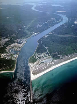
Cape Cod Canal with Scusset Beach at right
Relief map of USA Massachusetts.png
Red pog.svg
Location in Massachusetts
Usa edcp relief location map.png
Red pog.svg
Scusset Beach State Reservation (the United States)
Location Sandwich, Barnstable, Massachusetts, United States
Coordinates 41°46′45.7″N70°30′3.7″W / 41.779361°N 70.501028°W / 41.779361; -70.501028 Coordinates: 41°46′45.7″N70°30′3.7″W / 41.779361°N 70.501028°W / 41.779361; -70.501028
Area459 acres (186 ha) [1]
Established1957 [2]
Governing body Massachusetts Department of Conservation and Recreation
Website Scusset Beach State Reservation

Scusset Beach State Reservation is a state-operated, public recreation area located in the town of Sandwich in Barnstable County, Massachusetts, at the east end of the Cape Cod Canal on land formerly part of Sagamore Hill Military Reservation. In addition to its beach and campgrounds, prominent features of the park include Sagamore Hill, a one-time Native American meeting ground and site of World War II coastal fortifications, and a 3,000-foot (910 m) stone jetty that separates the canal and beach. Unlike most of Sandwich, this section of the town is on the mainland side of the Cape Cod Canal. The state park is managed by the Massachusetts Department of Conservation and Recreation under a lease agreement with the U.S. Army Corps of Engineers. [3] [4]

Contents

Activities and amenities

Related Research Articles

Cape Cod Canal Artificial waterway in the U.S. state of Massachusetts

The Cape Cod Canal is an artificial waterway in the U.S. state of Massachusetts connecting Cape Cod Bay in the north to Buzzards Bay in the south, and is part of the Atlantic Intracoastal Waterway. The approximately seven-mile-long (11 km) canal traverses the neck of land joining Cape Cod to the state's mainland. It mostly follows tidal rivers widened to 480 feet (150 m) and deepened to 32 feet (9.8 m) at mean low water, shaving 135 miles (217 km) off the journey around the Cape for its approximately 14,000 annual users.

Bourne, Massachusetts Town in Massachusetts, United States

Bourne is a town in Barnstable County, Massachusetts, United States. The population was 20,452 at the 2020 census.

Sandwich, Massachusetts Town in Massachusetts, United States

Sandwich is a town in Barnstable County, Massachusetts, and is the oldest town on Cape Cod. The town motto is Post tot Naufracia Portus, "after so many shipwrecks, a haven". The population was 20,259 at the 2020 census.

Department of Conservation and Recreation State agency of the Commonwealth of Massachusetts

The Department of Conservation and Recreation (DCR) is a state agency of the Commonwealth of Massachusetts, situated in the Executive Office of Energy and Environmental Affairs. It is best known for its parks and parkways. The DCR's mission is "To protect, promote and enhance our common wealth of natural, cultural and recreational resources for the well-being of all." The agency is the largest landowner in Massachusetts.

Horseneck Beach State Reservation

Horseneck Beach State Reservation is a public recreation area comprising more than 800 acres (320 ha) on the Atlantic Ocean in the southern portion of the town of Westport, Massachusetts. The reservation is one of the state’s "most popular facilities ... welcom[ing] hundreds of thousands of visitors per year." It is managed by the Massachusetts Department of Conservation and Recreation.

Mount Greylock State Reservation

Mount Greylock State Reservation is public recreation and nature preservation area on and around Mount Greylock, the highest point in the U.S. state of Massachusetts. The park covers some 12,000 acres (4,900 ha) in the towns of Lanesborough, North Adams, Adams, Cheshire, Williamstown and New Ashford, Massachusetts. It was created in 1898 as Massachusetts' first public land for the purpose of forest preservation.

Dorchester Shores Reservation is a Massachusetts state park consisting of three non-contiguous areas totaling 44 acres (18 ha) along the eastern edge of the Dorchester section of Boston. The area is composed of beaches and a park along the extended mouth of the Neponset River: Savin Hill/Malibu Beach, Tenean Beach, and Victory Road Park. Savin Hill is adjacent to Malibu Beach and has been restored to its original Olmsted Brothers design. The reservation is managed by the Department of Conservation and Recreation.

Lake Dennison Recreation Area State park in Winchendon, Massachusetts

Lake Dennison Recreation Area is a 121-acre (49 ha) Massachusetts state park located in the town of Winchendon. It comprises a small portion of the 4,221 acres (1,708 ha) of the U.S. Army Corps of Engineers' Birch Hill Flood Control Project that are managed by the Department of Conservation and Recreation and that also include Otter River State Forest.

Salisbury Beach State Reservation

Salisbury Beach State Reservation is a state-owned, public recreation area on the Atlantic Ocean in the town of Salisbury, Massachusetts, managed by the Massachusetts Department of Conservation and Recreation. It is one of the most heavily utilized state parks in the Commonwealth, with "an annual attendance rate of over one million visitors."

Sagamore Beach, Massachusetts Village in Massachusetts, United States

Sagamore Beach is a village of Bourne, Massachusetts fronting Cape Cod Bay and the east end of the Cape Cod Canal. It occupies the northern half of the Sagamore census-designated place. Along with Buzzards Bay and Bournedale, it is one of the three communities in Barnstable County that are north of the Cape Cod Canal.

Cape Cod Rail Trail

The Cape Cod Rail Trail (CCRT) is a 25.5-mile (41.0 km) paved rail trail located on Cape Cod in Massachusetts. The trail route passes through the towns of Yarmouth, Dennis, Harwich, Brewster, Orleans, Eastham, and Wellfleet. It connects to the 6-plus mile (10 km) Old Colony Rail Trail leading to Chatham, the 2 mile Yarmouth multi-use trail, and 8 miles (13 km) of trails within Nickerson State Park. Short side trips on roads lead to national seashore beaches including Coast Guard Beach at the end of the Nauset Bike Trail in Cape Cod National Seashore. The trail is part of the Claire Saltonstall Bikeway.

Claire Saltonstall Bikeway

The Claire Saltonstall Bikeway, also known as the Boston to Cape Cod Bikeway, is a 135-mile bikeway marked as Bike Route 1 that starts on the Charles River Bike Path near Boston University in Boston, Massachusetts and winds along Boston's Emerald Necklace, using mostly back roads and bikepaths with occasional stretches of secondary highways. It ends in Provincetown, Massachusetts. The bikeway was named on July 17, 1978, in memory of Claire Saltonstall, the daughter of Senator William L. Saltonstall. Claire was killed by an automobile in 1974 while she was riding her bicycle. Senator Saltonstall was a sponsor of bicycle safety legislation and was instrumental in developing the bikeway. Dual signs were erected along the route shortly after the bikeway opened, one with a picture of a bicycle in a green background and the green number 1 below the picture, and another rectangular sign with the words Claire Saltonstall Bikeway below that. Few of the original signs survive today, however, and new signs were erected in the summer of 2018.

Mount Sugarloaf State Reservation

Mount Sugarloaf State Reservation is a state-owned, public recreation area managed by the Massachusetts Department of Conservation and Recreation located in South Deerfield, just west of the Connecticut River. The state park includes the summits of North Sugarloaf Mountain and South Sugarloaf Mountain, as well as 1.75 miles of frontage on the Connecticut River and two river islands. The park is part of a larger park designation called the Connecticut River Greenway State Park. Portions of the park property along the river are used by the University of Massachusetts Amherst for agricultural research.

Erving State Forest

Erving State Forest is a publicly owned forest with recreational features located north of the Millers River in the towns of Erving, Warwick, and Orange, Massachusetts. The property is centered on Laurel Lake, a 51-acre (21 ha) body of water that has been a popular recreational destination since the 1930s. The forest's network of roads and hiking trails were largely created by the Civilian Conservation Corps. The forest is managed by the Department of Conservation and Recreation.

Nickerson State Park

Nickerson State Park is a state-owned, public recreation area of more than 1,900 acres (770 ha) located on Cape Cod in Brewster, Massachusetts. The park's sandy soil and scrub pines surround many kettle ponds which are dependent on groundwater and precipitation. The largest of these are Cliff Pond, Flax Pond, Little Cliff Pond, and Higgins Pond. Ruth Pond, Keeler's Pond, Eel Pond, and Triangle Pond provide additional water habitats.

Sagamore Hill Military Reservation

Sagamore Hill Military Reservation was a coastal defense site located in Sagamore Beach, Massachusetts. Today, the site is the location of Scusset Beach State Reservation.

Ellisville Harbor State Park

Ellisville Harbor State Park is a nature preserve and public recreation area located in the village of Ellisville, Massachusetts, United States, on the western shore of Cape Cod Bay. Natural features of the coastal property include a barrier beach, sphagnum bog, salt marsh, rolling meadows, and red pine forest habitats. Scenic features include views of the South Shore coastline, small fishing boats, harbor seals seen offshore during fall and winter, and birds attracted to the park's bog as both habitat and migration stopover. The state park is managed by the Department of Conservation and Recreation.

Shawme-Crowell State Forest

Shawme-Crowell State Forest is a Massachusetts state forest located in the town of Sandwich in Barnstable County. The forest lost much of its original acreage with the creation of Camp Edwards, which is part of the modern-day Joint Base Cape Cod. The forest is made up of pitch pine and scrub oaks and is managed by the Department of Conservation and Recreation.

Tolland State Forest

Tolland State Forest is a publicly owned forest with recreational features covering 4,415 acres (1,787 ha) in the towns of Otis, Tolland, Blandford and Sandisfield in the southern Berkshire Hills of Massachusetts. The state forest centers on the 1,065-acre (431 ha) Otis Reservoir, the largest body of water for recreational use in western Massachusetts. The forest is managed by the Department of Conservation and Recreation.

Willard Brook State Forest

Willard Brook State Forest is a publicly owned forest with recreational features located in the towns of Ashby and Townsend, Massachusetts. The forest's fast-running brook and tree stands of a classic New England nature give it a character more in line with that of the forests found farther west in the state. It is managed by the Department of Conservation and Recreation.

References

  1. "2012 Acreage Listing" (PDF). Department of Conservation and Recreation. April 2012. Retrieved September 22, 2015.
  2. "Park History". Friends of Scusset Beach State Reservation. Retrieved September 22, 2015.
  3. 1 2 "Scusset Beach State Reservation". MassParks. Executive Office of Energy and Environmental Affairs. Retrieved July 15, 2013.
  4. 1 2 "Recreation Facilities/Activities". Cape Cod Canal. U.S. Army Corps of Engineers. Retrieved July 15, 2013.
  5. 1 2 "Beach, Campground". Friends of Scusset Beach State Reservation. Retrieved September 22, 2015.
  6. "Things to Know Before You Go". Scusset Beach State Reservation. Executive Office of Energy and Environmental Affairs. Retrieved July 15, 2013.
  7. "Shawme-Crowell State Forest". MassParks. Executive Office of Energy and Environmental Affairs. Retrieved July 15, 2013.