
Buttermilk Falls State Park is a 811-acre (3.28 km2) state park located southwest of Ithaca, New York, United States. Like Robert H. Treman State Park, a portion of the land that was to become the state park came from Robert and Laura Treman in 1924.

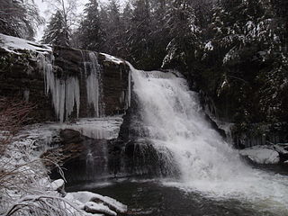
Chittenango Falls State Park is a 193-acre (0.78 km2) state park located in Madison County, New York, east of Cazenovia Lake. The park features a 167-foot (51 m) waterfall that cascades over roughly 400-million-year-old bedrock. At the bottom of the falls Chittenango Creek flows underneath a wooden bridge. The park offers a variety of activities including picnic tables with pavilions, a playground, a nature trail, hiking, and fishing.

Taughannock Falls State Park is a 750-acre (3.0 km2) state park located in the town of Ulysses in Tompkins County, New York in the United States. The park is northwest of Ithaca near Trumansburg.

Robert H. Treman State Park is a 1,110-acre (4.5 km2) state park located in Tompkins County, in the Finger Lakes region of New York in the United States. The park is situated in the towns of Ithaca, Enfield and Newfield.

Bash Bish Falls State Park is a Massachusetts state park located in the town of Mount Washington. The park is named after Bash Bish Falls, Massachusetts' highest single-drop waterfall, which lies within its borders. The park is managed by the Department of Conservation and Recreation and is one of several nature preserves in the extreme southwestern corner of Massachusetts noted for their scenery. It is adjacent to the 4,000-acre (1,600 ha) Mount Washington State Forest, as well as New York's 5,000-acre (2,000 ha) Taconic State Park.
Swallow Falls State Park is a public recreation area located on the west bank of the Youghiogheny River nine miles (14 km) northwest of Oakland in Garrett County, Maryland, in the United States. The state park features Maryland's highest free-falling waterfall, the 53-foot (16 m) Muddy Creek Falls, as well as smaller waterfalls on the Youghiogheny River and Tolivar Creek. The park is notable for its stand of old hemlock trees, some more than 300 years old, "the last stand of its kind in Maryland."

Wadsworth Falls State Park, or simply Wadsworth Falls, is a public recreation and preserved natural area located on the Coginchaug River in the towns of Middletown and Middlefield, Connecticut. The state park's 285 acres (115 ha) offer trail hiking and fishing. Swimming and picnicking are allowed at the pond near the north entrance near 721 Wadsworth Street in Middletown. It is managed by the Connecticut Department of Energy and Environmental Protection.
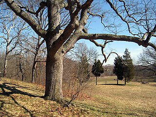
Beaver Brook Reservation is a public recreation area covering 303 acres (123 ha) on the dividing line between the town of Belmont and the city of Waltham, Massachusetts. The state park is managed by the Massachusetts Department of Conservation and Recreation.

Moore State Park is a 737-acre (298 ha) public recreation area located in the town of Paxton, Massachusetts, USA, portions of which were listed on the National Register of Historic Places as the Moore State Park Historic District in 2004. Features of the state park include historical building foundations, a restored sawmill, Eames Pond, waterfalls and mill chutes as well as abundant azaleas, rhododendrons, and mountain laurel. The park is managed by the Massachusetts Department of Conservation and Recreation.

Savoy, Mountain State Forest is a Massachusetts state forest located primarily in the towns of Savoy and Florida, with portions extending into neighboring Adams and North Adams. Situated along the Hoosac Mountain Range, it features four ponds, and seven hill and mountain summits, including Lewis Hill (2177 ft), Flat Rock Hill (2195 ft), Spruce Hill (2566 ft), and Borden Mountain (2505 ft). Also within the forest are at least two notable waterfalls, Parker Brook Falls and Tannery Falls, the latter of which is a 100-foot (30 m) drop. The forest is managed by the Department of Conservation and Recreation.

Wallace Falls State Park is a public recreation area that encompasses 1,380 acres (560 ha) along the Wallace River in Snohomish County, Washington. The state park is located on the west side of the Cascade Mountains with an entrance point one mile (1.6 km) northeast of the community of Gold Bar. The park features three waterfalls, three backcountry lakes, old-growth coniferous forests, rushing mountain rivers and streams, and the evidence of its logging history in the ruins of railroad trestles, disused railroad grades, and springboard notches in stumps.

Kent Falls State Park is a public recreation area located in the town of Kent, Connecticut, within the Litchfield Hills region of the southern Berkshires. The state park is home to Kent Falls, a series of waterfalls on Falls Brook, a tributary of the Housatonic River. The falls drop 250 feet (76 m) in under a quarter mile. The largest cascade drops more than 70 feet (21 m) into a reflecting pool, before traveling over the lesser falls.

Silver Falls State Park is a state park in the U.S. state of Oregon, located near Silverton, about 20 miles (32 km) east-southeast of Salem. It is the largest state park in Oregon with an area of more than 9,000 acres (36 km2), and it includes more than 24 miles (39 km) of walking trails, 14 miles (23 km) of horse trails, and a 4-mile (6.4 km) bike path. Its 8.7-mile (14.0 km) Canyon Trail/Trail of Ten Falls runs along the banks of Silver Creek and by ten waterfalls, from which the park received its name. Four of the ten falls have an amphitheater-like surrounding that allows the trail to pass behind the flow of the falls. The Silver Falls State Park Concession Building Area and the Silver Creek Youth Camp-Silver Falls State Park are separately listed on the U.S. National Register of Historic Places.

Cunningham Falls State Park is a public recreation area located west of Thurmont, Maryland, in the United States. The state park is the home of Cunningham Falls, the largest cascading waterfall in Maryland, a 43-acre (17 ha) man-made lake, and the remains of a historic iron furnace. The park is one of several protected areas occupying 50-mile-long Catoctin Mountain; it is bordered on its north by Catoctin Mountain Park and on its south by Frederick Municipal Forest.

DeSoto State Park is a public recreation area located on Lookout Mountain 8 miles (13 km) northeast of Fort Payne, Alabama. The state park covers 3,502 acres (1,417 ha) of forest, rivers, waterfalls, and mountain terrain. It borders the Little River, which flows into the nearby Little River Canyon National Preserve. The 104-foot-tall (32 m) DeSoto Falls, the state's highest waterfall, is found in a separate part of the park 6 miles (9.7 km) north of the main park.

Rainbow Falls State Park is a public recreation area on the Chehalis River one mile east of the town of Dryad, Washington. The state park's 129 acres (52 ha) feature 3,900 feet (1,200 m) of shoreline, the waterfall for which the park is named, and some of the last standing old-growth trees in the Chehalis Valley.

Zapata Falls is a waterfall located in the San Luis Valley near the base of the Sangre de Cristo Mountains on Bureau of Land Management land adjacent to Rio Grande National Forest and south of Great Sand Dunes National Park and Preserve in Alamosa County, Colorado. The waterfall has a drop of about 30 feet (9 m). Access to this waterfall entails a mildly steep 0.5-mile (800 m) hike. Viewing the falls requires fording the stream and climbing rocks.

Willard Brook State Forest is a publicly owned forest with recreational features located in the towns of Ashby and Townsend, Massachusetts. The forest's fast-running brook and tree stands of a classic New England nature give it a character more in line with that of the forests found farther west in the state. It is managed by the Department of Conservation and Recreation.

There are 24 named waterfalls in Ricketts Glen State Park in the U.S. state of Pennsylvania along Kitchen Creek as it flows in three steep, narrow valleys, or glens. They range in height from 9 feet (2.7 m) to the 94-foot (29 m) Ganoga Falls. Ricketts Glen State Park is named for R. Bruce Ricketts, a colonel in the American Civil War who owned over 80,000 acres (32,000 ha) in the area in the late 19th and early 20th centuries, but spared the old-growth forests in the glens from clearcutting. The park, which opened in 1944, is administered by the Bureau of State Parks of the Pennsylvania Department of Conservation and Natural Resources (DCNR). Nearly all of the waterfalls are visible from the Falls Trail, which Ricketts had built from 1889 to 1893 and which the state park rebuilt in the 1940s and late 1990s. The Falls Trail has been called "the most magnificent hike in the state" and one of "the top hikes in the East".

Chester-Blandford State Forest is a publicly owned forest with recreational features located in the two towns for which it is named, Chester and Blandford, Massachusetts. The state forest includes remnants of small mining operations and the 60-foot cascade at Sanderson Brook Falls. It is managed by the Department of Conservation and Recreation.


