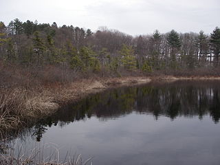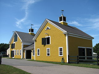
Long Point Wildlife Refuge is a wildlife refuge and nature reserve located in West Tisbury, Massachusetts. The property is owned by The Trustees of Reservations; it has grown in size since its first purchase in 1979. [1]

Long Point Wildlife Refuge is a wildlife refuge and nature reserve located in West Tisbury, Massachusetts. The property is owned by The Trustees of Reservations; it has grown in size since its first purchase in 1979. [1]
Canoe and kayak rentals are available in July and August. [2]
In March 2020, the refuge was closed to the public because of the COVID-19 pandemic. [3] In June 2020, the refuge reopened, but visitors were required to purchase tickets in advance online. [1] The advance ticketing requirement remained in place for summer 2021. [4]

Benson County is a county in the U.S. state of North Dakota. As of the 2010 United States Census, the population was 6,660. Its county seat is Minnewaukan. The county was created on March 9, 1883 by the Dakota Territory legislature, and was named for Bertil W. Benson, a Dakota Territory legislator at the time. The county government was organized on June 4, 1884, and its boundary lines were altered by two legislative actions in 1885.

Lake County is a county located in the northwest part of the U.S. state of Montana. As of the 2010 United States Census, the population was 28,746. Its county seat is Polson.

Chappaquiddick Island, a part of the town of Edgartown, Massachusetts, is a small peninsula and occasional island on the eastern end of Martha's Vineyard. Norton Point, a narrow barrier beach, connects Martha's Vineyard and Chappaquiddick between Katama and Wasque. Occasional breaches occur due to hurricanes and strong storms separating the islands for periods of time. Most recently, the two were separated for 8 years from 2007 to 2015. While both land forms have mostly been connected to one another in modern history, Chappaquiddick is nevertheless referred to as an island.

The Bison Range (BR), formerly the National Bison Range, is a nature reserve on the Flathead Indian Reservation in western Montana established as a wildlife conservation area for the American bison. The size of the bison herd at the BR is between 350 and 500. Established as a National Wildlife Refuge in 1908, the BR consists of approximately 18,800 acres (7,600 ha) within the Montana valley and foothill grasslands. The management is in the process of being transferred from the U.S. Fish and Wildlife Service to the Confederated Salish and Kootenai Tribes.

Egmont Key State Park and National Wildlife Refuge is a Florida State Park located on the island of Egmont Key, at the mouth of Tampa Bay. Egmont Key lies southwest of Fort De Soto Park and can only be reached by boat or ferry. Located within Egmont Key State Park are the 1858 Egmont Key Lighthouse, maintained by the U.S. Coast Guard, and the ruins of Fort Dade, a Spanish–American War era fort that housed 300 residents. Egmont Key is located in Hillsborough County Florida on a narrow strip of the county that extends along the Tampa Port Shipping Channel.

The Stewart B. McKinney National Wildlife Refuge is a 950-acre (384.5 ha) National Wildlife Refuge in ten units across the U.S. state of Connecticut. Located in the Atlantic Flyway, the refuge spans 70 miles (110 km) of Connecticut coastline and provides important resting, feeding, and nesting habitat for many species of wading birds, shorebirds, songbirds and terns, including the endangered roseate tern. Adjacent waters serve as wintering habitat for brant, scoters, American black duck, and other waterfowl. Overall, the refuge encompasses over 900 acres (364.2 ha) of barrier beach, intertidal wetland and fragile island habitats.

Cape Poge Wildlife Refuge is a wildlife refuge on Chappaquiddick Island owned and managed by The Trustees of Reservations. The refuge consists of 516 acres (2.09 km2) and includes the 1893 Cape Poge Lighthouse.

Agassiz Rock is a 116-acre (47 ha) park in Manchester-by-the-Sea, Massachusetts, owned and maintained by The Trustees of Reservations. The park's name is from two examples of large glacial erratic boulders plucked from bedrock. As glaciers scoured this landscape, the mass of bedrock forming the hill proved more resistant than the surrounding soil, forcing the bottom of the glacier up and over the hill. The north side was smoothed and the south side left steep and rugged as the glacier broke off chunks of rock as it passed.

Mashpee River Reservation is a park in Mashpee, Massachusetts on the Mashpee River. The Trustees of Reservations owns and maintains the park.

Mytoi is a small Japanese garden set within an open pine forest on Chappaquiddick Island, in Martha's Vineyard, Massachusetts. The Trustees of Reservations owns and maintains the property.

The Charles W. Ward Reservation is a 704-acre (285 ha) open space reserve located in Andover and North Andover, Massachusetts, 20 miles (32 km) north of Boston. The reserve, managed by the land conservation non-profit organization The Trustees of Reservations, is notable for its open drumlin hilltops and vistas encompassing Boston and Salem. The Ward Reservation offers 13 miles (21 km) of trails and former woods roads available for hiking, horseback riding, mountain biking, and cross country skiing; it is also a link in the 200-mile (320 km) Bay Circuit Trail system.

Crane Beach is a 1,234-acre (4.99 km2) conservation and recreation property located in Ipswich, Massachusetts, immediately north of Cape Ann. It consists of a four-mile-long (6 km) sandy beachfront, dunes, and a maritime pitch pine forest. Five and a half miles of hiking trails through the dunes and forest are accessible from the beachfront.
Menemsha Hills is a protected nature reserve located on Martha's Vineyard, Massachusetts in the town of Chilmark. The property is owned by The Trustees of Reservations through three grants of land, the first in 1966. The reserve is adjacent to another Trustees property, The Brickyard.
Wasque ("way-squee") or Wasque Beach is a 200-acre (0.81 km2) nature reserve on Chappaquiddick Island, Martha's Vineyard, Massachusetts. The site was established as a reservation for the public in 1967 and is one of five conservation areas on "the Vineyard" managed by the Trustees of Reservations. Wasque contains a sandy strand the Boston Globe calls "a magnificent beach." Travel + Leisure named Wasque Beach the number one beach in New England and WHDH-TV reports "It's pristine, serene, and rain or shine, it's a beach-goers' delight." Off the shore of Wasque Beach is Katama Bay, "a vast and pristine salt water bay that includes many acres of productive shellfish beds."

The Crane Wildlife Refuge, located in Ipswich and Essex, Massachusetts, is a 674-acre (2.73 km2) property managed by The Trustees of Reservations. Located nearby are the Trustees of Reservations managed Castle Hill and Crane Beach. The refuge was established in 1974.
The Coskata-Coatue Wildlife Refuge is a nature preserve on Nantucket Island and is managed by the Trustees of Reservations. It encompasses miles of beaches, the largest red cedar woodland in New England and Great Point Light. The reservation began with an acquisition of land in 1974.

The East Over Reservation is a 75-acre (300,000 m2) nature preserve and working farm in Rochester, Massachusetts, USA, and is managed by the Trustees of Reservations. There are hiking trails, quarry-stone walls and a "treasure hunt", designed to test one's map reading skills. It was protected between 2003 and 2005.

The Lowell Holly Reservation is a 135-acre (0.55 km2) nature reserve in Mashpee and Sandwich, Massachusetts and is managed by the Trustees of Reservations. The area was extensively planted by Abbot Lawrence Lowell and Wilfred Wheeler with rhododendrons, mountain laurel and holly trees, for which the reservation gets its name. There are 4 miles (6.4 km) of hiking trails and two peninsular knolls that jut into Mashpee Pond and Wakeby Pond. Abbot Lawrence Lowell bequeathed the property to the Trustees of Reservations in 1943.
The Lyman Reserve is a 210-acre (0.85 km2) nature reserve in Bourne, Plymouth and Wareham, Massachusetts and is managed by the Trustees of Reservations. There are 1.5 miles (2.4 km) of hiking trails, a beach and is in proximity to the Red Brook Reserve and Red Brook Wildlife Management Area. The area was formerly as private fishing camp, which sits at the mouth of Red Brook at Buttermilk Bay. It is home to one of the last remaining groups of sea-run brook trout ("salters") in the Eastern United States.

Choate Island, also known as Hog Island, is an island located in the Essex River Estuary in Essex, Massachusetts. It is part of the Crane Wildlife Refuge, which is owned and managed by The Trustees of Reservations. The 135-acre (0.55 km2) island is a refuge for a variety of birds and animals. It is surrounded by a salt marsh and has a spruce forest which was planted in the 1930s and makes the island easily visible from much of the surrounding area. The island has been inhabited by the Native Americans of the area, and was visited by early Europeans, who established farming on the island. The Choate House, built around 1730, remains relatively unchanged.
Coordinates: 41°21′38″N70°38′0″W / 41.36056°N 70.63333°W