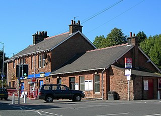
Barassie railway station is a railway station serving Barassie, South Ayrshire, Scotland. The station is managed by ScotRail and is on the Ayrshire Coast Line.

Maybole railway station is a railway station serving the town of Maybole, South Ayrshire, Scotland. The station is owned by Network Rail and managed by ScotRail and is on the Glasgow South Western Line.

Girvan railway station is a railway station serving the town of Girvan, South Ayrshire, Scotland. The station is managed by ScotRail, who operate all passenger services from there. It is on the Ayr to Stranraer section of the Glasgow South Western Line and is situated 62 miles south of Glasgow Central. It has two platforms and is the location of one of the five passing loops on the single track line between Dalrymple Junction and Stranraer. Immediately south of the station, the line climbs steeply towards Pinmore tunnel – the climb is known as the Glendoune Bank and has a ruling gradient of 1 in 54.

Auchenmade railway station was a railway station approximately three miles north-east of Kilwinning on the B707, North Ayrshire, Scotland. It served the hamlet of Auchentiber and the surrounding rural area as part of the Lanarkshire and Ayrshire Railway. The station was 6.75 miles from the Lugton East Junction.

Saltcoats North railway station was a railway station serving the town of Saltcoats, North Ayrshire, Scotland as part of the Lanarkshire and Ayrshire Railway.

Dreghorn railway station was a railway station serving the village of Dreghorn, North Ayrshire, Scotland. The station was originally part of the Glasgow, Paisley, Kilmarnock and Ayr Railway. The line forms part of National Cycle Route 73, and the site of the station is marked by signs at the junction with Station Brae, Dreghorn.

Dunure railway station was a railway station serving the village of Dunure, South Ayrshire, Scotland. The station was part of the Maidens and Dunure Light Railway.
The Maybole and Girvan Junction Railway was a railway company that constructed a line between Maybole and Girvan. Although promoted independently, it was supported by the Glasgow and South Western Railway, and was seen as part of a trunk line connecting Glasgow with a ferry port for the north of Ireland.

Dalrymple railway station was a railway station serving the village of Dalrymple, East Ayrshire, Scotland. The station was originally part of the Ayr and Maybole Junction Railway.

Cassillis railway station was a railway station serving the village of Minishant, South Ayrshire, Scotland. The station was originally part of the Ayr and Maybole Junction Railway.
Maybole railway station was a railway station serving the village of Maybole, South Ayrshire, Scotland. The station was originally part of the Ayr and Maybole Junction Railway.
Maybole Junction railway station was a railway station located between Alloway and Dalrymple in South Ayrshire, Scotland. The station was originally part of the Ayr and Dalmellington Railway.

Drumclog was a railway station on the Darvel and Strathaven Railway serving a rural area that included the village of Drumclog in South Lanarkshire, Scotland.

Gree Goods station or Gree Depot as it was listed in the Caledonian Railway Working Timetable was a relatively short lived railway freight facility located approximately one miles south of Lugton on the A736 Lochlibo Road, North Ayrshire, Scotland. Gree Goods served the industrial and agricultural requirements for transportation in the vicinity, with the village of Burnhouse not far away, sitting on the crossroads to Barrmill, Dunlop and Irvine. Over Gree, High Gree, Nether Gree, Gree and Brownhills Farms were located nearby. Gree Goods was close to the Lugton East Junction, just south of the 11 arch Gree Viaduct. The nearest passenger station on the line north was Lugton High and to the south was Giffen.

Netherton Goods station or Netherton Depot was a railway public freight facility located between Neilston railway station and Patterton railway station just west of the proposed site of Lyoncross railway station, East Renfrewshire, Scotland. Netherton Goods served the industrial and agricultural requirements for transportation in the vicinity, with the town of Arthurlie not far away, sitting on and near to country lanes to Neilston, Arthurlie and Barrhead. Netherton, Glanderston, Balgraystone and Dyke Farms were located nearby. Netherton Goods was close to Lyoncross Junction between the Lanarkshire and Ayrshire Railway and the Paisley and Barrhead District Railway near Balgray Reservoir.

The Grangeston Halt railway station was a private station that was not listed in the public timetables, located in a rural part of South Ayrshire, Scotland and served the WWII Grangeston ICI munitions plant bringing workers to the site. Grant's Distillery now occupies much of the site.

Girvan Old railway station was a terminus station opened in Girvan, in Carrick, South Ayrshire, Scotland by the Maybole and Girvan Railway. Although ambitions existed to extend the line through to Stranraer it was built on a site that would not permit this and so when the line was built the Girvan New station was opened on 5 October 1877 by the Girvan and Portpatrick Junction Railway on the route to Pinmore and eventually through to Stranraer railway station.

Garrochburn Goods Depot or Garrochburn Siding was a railway freight facility located off the B744 near the hamlet of Crosshands that lies north-west of Mauchline, East Ayrshire, Scotland. It served the industrial and agricultural requirements for transportation in the vicinity of Crosshands and the surrounding rural area, originally on behalf of the Glasgow and South-Western Railway. Garrochburn Goods Depot was 40.4 miles (65.0 km) from Glasgow, 6.82 miles (10.98 km) from Kilmarnock and 2.72 miles (4.38 km) from Mauchline. The old clachan of Ladeside once stood nearby and the mill at Dalsangan remains as a private house having lost its water supply upon the draining of Loch Brown when the railway was built, that is apart from that of the Garroch or Ladeside Burn that cuts under the railway to the south of the old siding.

Mossgiel Tunnel Platform railway station (NS480292) was not a station constructed for public use. It stood close to the northern portal of the 680 yard Mossgiel Tunnel that runs under the Mossgiel Ridge and Skeoch Hill north of Mauchline, East Ayrshire, Scotland. It may have solely served the transportation requirements of the Glasgow and South-Western Railway and its successor in connection with the carriage of workers involved in the ongoing maintenance and/or the major reconstruction of Mossgiel Tunnel that took place between 1925 and 1927. It was not recorded in the 1896 G&SWR working time table and had closed sometime after July 1926.

Weston Bridge Platform railway station or Weston Bridge Halt railway station was opened to serve miners travelling to the Ayr Colliery No. 9 Pit that stood near Annbank and those from the village that worked at other pits in the area, East Ayrshire, Scotland. The station was on the line that was originally part of the Ayr and Cumnock Branch of the Glasgow and South Western Railway. The location was well chosen as it lay close to the village, the hamlet of Burnbrae and at the busy crossroads at Weston Bridge.


