
The Royal Borough of Kensington and Chelsea is an Inner London borough with royal status. It is the smallest borough in London and the second smallest district in England; it is one of the most densely populated administrative regions in the United Kingdom. It includes affluent areas such as Notting Hill, Kensington, South Kensington, Chelsea, and Knightsbridge.
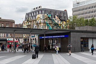
King's Cross St Pancras is a London Underground station on Euston Road in the Borough of Camden, Central London. It serves King's Cross and St Pancras main line stations in fare zone 1, and is an interchange between six Underground lines. The station was one of the first to open on the network. As of 2022, it is the most used station on the network for passenger entrances and exits combined.

Crossrail was a railway construction project centred around London. It aimed to provide a high-frequency hybrid commuter rail and rapid transit system crossing the capital from suburbs on the west to east, by connecting two major railway lines terminating in London: the Great Western Main Line and the Great Eastern Main Line. The project was approved in 2007, and construction began in 2009 on the central section and connections to existing lines that became part of the route, which has been named the Elizabeth line in honour of Queen Elizabeth II who opened the line on 17 May 2022 during her Platinum Jubilee. The central section of the line between Paddington and Abbey Wood opened on 24 May 2022, with 12 trains per hour running in each direction through the core section in Central London.

Clapham Junction railway station is a major railway station and transport hub near St John's Hill in southwest Battersea in the London Borough of Wandsworth. It is 2 miles 57 chains from London Victoria and 3 miles 74 chains from London Waterloo; it is on both the South West Main Line and Brighton Main Line as well as numerous other routes and branch lines passing through or diverging from the main lines at this station. Despite its name, Clapham Junction is not located in Clapham, a district situated approximately 1 mile (1.6 km) to the southeast and is instead sited in Battersea.

The North London line (NLL) is a railway line which passes through the inner suburbs of west, north-west, north, and north-east London, England between Richmond in the south-west and Stratford in the east, avoiding central London. Its route is a rough semicircle.

Chelsea is an affluent area in West London, England, due south-west of Charing Cross by approximately 2.5 miles. It lies on the north bank of the River Thames and for postal purposes is part of the south-western postal area.

Sloane Square is a London Underground station in Chelsea, serving Sloane Square. It is served by the District and Circle lines, between South Kensington and Victoria stations and is in Travelcard Zone 1.
King's Road or Kings Road is a major street stretching through Chelsea and Fulham, both in west London, England. It is associated with 1960s style and with fashion figures such as Mary Quant and Vivienne Westwood. Sir Oswald Mosley's Blackshirt movement had a barracks on the street in the 1930s.

Essex Road is a National Rail station in Canonbury in Greater London, England, and is on the Northern City Line between Old Street and Highbury & Islington, 1 mile 59 chains (2.8 km) down the line from Moorgate, and is in Travelcard Zone 2. The station is at the junction of Essex Road, Canonbury Road and New North Road, with the present entrance on Canonbury Road. Operated by Great Northern, it is the only deep-level underground station in London served exclusively by National Rail trains. Between 1933 and 1975 the station was operated as part of the London Underground, as a short branch of the Northern line. Between 1922 and 1948 the station name was Canonbury & Essex Road. The name reverted to the original form in 1948.

The West London line is a short railway in inner West London that links Clapham Junction in the south to Willesden Junction in the north. The line has always been an important cross-London link especially for freight services. Southern and London Overground provide regular passenger services; detailed below.

Hackney Central is a London Overground station on the North London line in Hackney Central, north-east London. It lies between Dalston Kingsland and Homerton and is in Travelcard Zone 2. The station and all trains serving it are operated by London Overground services which are managed by Transport for London. However, there is no standard red National Rail "double arrow" logo signage at the station, instead only the Overground roundel.
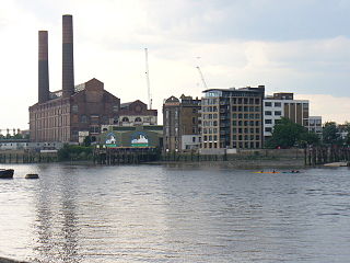
Counter's Creek, ending in Chelsea Creek, the lowest part of which still exists, was a stream that flowed from Kensal Green, by North Kensington and flowed south into the River Thames on the Tideway at Sands End, Fulham. Its remaining open watercourse is the quay of Chelsea Creek.
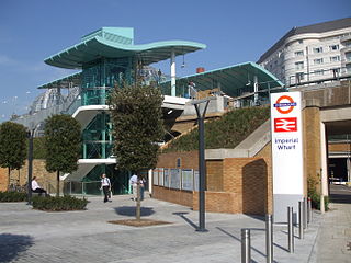
Imperial Wharf is an interchange station located in Sands End in West London for London Overground and National Rail services.

Cremorne Gardens were popular pleasure gardens by the side of the River Thames in Chelsea, London. They lay between Chelsea Harbour and the end of the King's Road and flourished between 1845 and 1877; today only a vestige survives, on the river at the southern end of Cheyne Walk.

Crossrail 2 is a suspended proposal for a hybrid commuter rail and rapid transit route in South East England, running from nine stations in Surrey to three in Hertfordshire, providing a new North–South rail link across Greater London. It would connect the South West Main Line to the West Anglia Main Line, via Victoria and King's Cross St Pancras. The intent was to alleviate severe overcrowding that would otherwise occur on commuter rail routes into Central London. When first proposed, the hope was for construction to start around 2023, with the new line opening from the early 2030s. The project's cost has been estimated at £31.2 billion.

The Bakerloo line extension is a proposed extension of the London Underground Bakerloo line in South London from its current terminus at Elephant & Castle to Lewisham station.

The Northern line extension to Battersea is an extension of the London Underground from Kennington to Battersea in South West London, terminating at the redeveloped Battersea Power Station. The extension formed a continuation of the Northern line's Charing Cross branch and was built beginning in 2015; it opened in 2021.
Ladbroke Grove is a proposed railway station in London, England on the Crossrail Route between Old Oak Common and Paddington. This is not part of the internal route and would be added at a later stage. Locals want the station to be called Portobello Central to serve the nearby Portobello Market. It was originally called Kensal.
The Crossrail line was first proposed in 1941. It was first proposed to Parliament in 1991 but was rejected. It was then proposed by the government as the Crossrail bill in 2005. Construction started in 2009 and, heavily delayed, the central section was opened by Elizabeth II on 24 May 2022 with full completion due in 2023.

Dovehouse Street is a street in Chelsea, London. It runs roughly north to south from Fulham Road to King's Road, having junctions with Cale Street and Britten Street, among others.


