Liberty Bridge | |
|---|---|
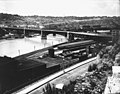
 The bridge in 2023 | |
| Coordinates | 40°25′58″N79°59′48″W / 40.4328°N 79.9967°W |
| Carries | 4 lanes of roadway |
| Crosses | Monongahela River |
| Locale | Pittsburgh, Pennsylvania |
| Official name | Liberty Bridge |
| Other name | South Hills Bridge |
| Maintained by | Allegheny County |
| Characteristics | |
| Design | Cantilever bridge |
| Material | Steel |
| Total length | 2,663 feet (812 m) |
| Longest span | 2 spans, each 448 feet (137 m) |
| Clearance below | 44.4 feet (13.5 m) |
| History | |
| Opened | March 27, 1928 |
| Statistics | |
| Daily traffic | 63,000 [1] |
| Location | |
 Interactive map of Liberty Bridge | |
The Liberty Bridge, which was completed in 1928, connects downtown Pittsburgh, Pennsylvania, to the Liberty Tunnels and the South Hills neighborhoods beyond. It crosses the Monongahela River and intersects Interstate 579 (the Crosstown Boulevard) at its northern terminus.
Contents
It was designed by George S. Richardson and cost $3,456,000 to build.