List of census localities in Scotland

Last updated

[ needs update ] A census locality in Scotland is a reporting district for results from the 2001 census corresponding to all or part of an urban area.

Contents

City of Aberdeen

Locality Population
(2001)
Area
(ha)
Population
density
Aberdeen (1)184,788550133.6
Cove Bay (1)687923529.3
Dyce (1)566135815.8
Kingswells 398414926.7
Peterculter-Milltimber 666224826.9
  1. Aberdeen Settlement.

Aberdeenshire

Locality Population
(2001)
Area
(ha)
Population
density
Aberchirder 11494923.4
Aboyne 22022289.7
Alford 19259819.6
Ballater 14468616.8
Balmedie 165311714.1
Banchory 603435217.1
Banff 399114128.3
Blackburn 13865027.7
Boddam 13647717.7
Inverallochy and Cairnbulg 11974824.9
Crimond 7936412.4
Cruden Bay 16089217.5
Cuminestown 457835.5
Drumoak 716769.4
Ellon 875436324.1
Fraserburgh 12,45443428,7
Fyvie 493855.8
Gardenstown 7335812.6
Gourdon 5942227.0
Hatton of Cruden 8056412.6
Huntly 441217525.2
Insch 15239116.7
Inverbervie 20947527.9
Inverurie 10,88239627.5
Johnshaven 6463319.6
Kemnay 369714825.0
Kintore 16969018.8
Laurencekirk 18089818.4
Longside 7214815.0
Macduff 376714226.5
Maud 6304215.0
Mintlaw 264715916.6
New Deer 519588.9
New Pitsligo 9275616.6
Newburgh 13926621.1
Newmachar 23185442.9
Newtonhill 29407439.7
Oldmeldrum 20039620.9
Peterhead 17,94758330.8
Pitmedden 11374028.4
Portlethen 660326724.7
Portsoy 173411315.3
Potterton 8867012.7
Rosehearty 11948813.6
Rothienorman 5393615.0
St Combs 6973818.3
St Cyrus 9025416.7
Sandhaven 7062825.2
Stonehaven 957725837.1
Strichen 8795017.6
Stuartfield 6653917.1
Tarland 5205010.4
Tarves 9143526.1
Torphins 10946816.1
Turriff 445420921.3
Westhill 949833928.0
Whitehills 10124622.0

Angus

Locality Population
(2001)
Area
(ha)
Population
density
Arbroath 22,78576729.7
Birkhill-Muirhead 19362288.5
Brechin 719926427.3
Carnoustie 10,56136129.3
Edzell 7834716.7
Ferryden (1)9292635.7
Forfar 13,20645928.8
Friockheim 8203722.2
Hillside 10145418.8
Kirriemuir 596322826.2
Letham 14989815.3
Montrose (1)10,84542125.8
Newtyle 7223719.5
Wellbank 5843118.8
  1. Montrose Settlement.

Argyll and Bute

Locality Population
(2001)
Area
(ha)
Population
density
Ardrishaig 12837616.9
Bowmore 8624917.6
Campbeltown 514422722.7
Cardross 19257426.0
Dunbeg 7302233.2
Dunoon (1)825136222.8
Garelochhead 12655622.6
Helensburgh (2)14,62649729.4
Innellan 11881697.0
Kilcreggan 14141758.1
Lochgilphead 232618112.9
Oban 812016624.9
Port Bannatyne 13545823.3
Port Ellen 819998.3
Rhu and Shandon (2)185418610.0
Rosneath 9312833.3
Rothesay 501723621.3
Sandbank (1)8071316.2
Tarbert 133811411.7
Tobermory 9801875.2
  1. Dunoon Settlement.
  2. Helensburgh Settlement.

Clackmannanshire

Locality Population
(2001)
Area
(ha)
Population
density
Alloa (1)18,98991220.8
Alva 518115533.4
Clackmannan 345010333.5
Coalsnaughton (2)8701945.8
Dollar 287712822.5
Menstrie 20072448.2
Tillicoultry (2)540019128.3
Tullibody (1)68147858.7
  1. Alloa Settlement.
  2. Tillicoultry Settlement.

Dumfries and Galloway

Locality Population
(2001)
Area
(ha)
Population
density
Annan 838944318.9
Cargenbridge 6043020.1
Castle Douglas 367116122.8
Creetown 6853519.6
Dalbeattie 428918822.8
Dumfries 31,146122425.4
Eaglesfield 6164613.4
Eastriggs 16837821.6
Ecclefechan 7463720.2
Gatehouse of Fleet 8925915.1
Glenluce 6114613.3
Gretna 27059827.6
Kirkconnel 20748325.0
Kirkcudbright 344715222.7
Langholm 23119723.8
Locharbriggs 609657610.6
Lochmaben 19528024.4
Lockerbie 400923417.1
Moffat 21359722.0
Newton Stewart 357317120.9
Port William 4683015.6
Portpatrick 5855011.7
Sanquhar 20289222.0
Stranraer 10,85137029.3
Thornhill 15129316.3
Whithorn 8674519.3
Wigtown 9873627.4

City of Dundee

Locality Population
(2001)
Area
(ha)
Population
density
Dundee 154,674462433.5

East Ayrshire

Locality Population
(2001)
Area
(ha)
Population
density
Auchinleck 351214124.9
Bellsbank 16194536.0
Bonnyton 3722 [1] 13028.6
Catrine 20537427.7
Crosshouse 24547731.9
Cumnock 935833627.9
Dalmellington-Burnton 14075923.8
Dalrymple 12816818.8
Darvel 336111230.0
Drongan 30129232.7
Dunlop 8393623.3
Fenwick 8633326.2
Galston (1)500011942.0
Hurlford-Crookedholm 496814833.6
Kilmarnock 43,588134732.4
Kilmaurs 26017435.1
Logan 13336719.9
Mauchline 410512433.1
Muirkirk 16305629.1
New Cumnock 316515021.1
Newmilns (1)305712424.7
Ochiltree 6932527.7
Patna 217911119.6
Stewarton 658217737.2
  1. Galston-Newmilns Settlement.

East Dunbartonshire

Locality Population
(2001)
Area
(ha)
Population
density
Bearsden (1)27,967120023.3
Bishopbriggs (1)23,11866434,8
Kirkintilloch (2)20,28156336.0
Lennoxtown 377311632.5
Lenzie (2)887335225.2
Milngavie (1)12,79540431.7
Milton of Campsie 395010338.3
Torrance 24807234.4
Twechar 13635624.3
  1. Greater Glasgow Settlement.
  2. Kirkintilloch-Lenzie Settlement.

East Lothian

Locality Population
(2001)
Area
(ha)
Population
density
Aberlady 8732930.1
Cockenzie 549911149.5
Dunbar 635432619.5
East Linton 17447722.6
Elphinstone 5141436.7
Gifford 6883122.2
Gullane 217213616.0
Haddington 885127732.0
Longniddry 26139826.7
Macmerry 11137415.0
Musselburgh (1)22,11253541.3
North Berwick 622323027.1
Ormiston 20794546.2
Pencaitland 15666723.4
Prestonpans 715318438.9
Tranent 889223138.5
West Barns 5553217.3
Whitecraig 12784032.0
  1. Edinburgh Settlement.

East Renfrewshire

Locality Population
(2001)
Area
(ha)
Population
density
Barrhead (1)17,24451133.7
Busby (1)16541679.9
Clarkston (1)19,13650637.8
Eaglesham 312712525.0
Giffnock (1)16,17849132.9
Neilston 516811644.6
Newton Mearns (1)22,63776829.5
Uplawmoor 5953218.6
Waterfoot 12793536.5
  1. Greater Glasgow Settlement.

City of Edinburgh

Locality Population
(2001)
Area
(ha)
Population
density
Edinburgh (1)430,08211,47537.5
Kirkliston 30436944.1
Queensferry 937024438.4
Ratho 15186822.3
Ratho Station 10132114.8
  1. Edinburgh Settlement.

Eileanan Siar

Locality Population
(2001)
Area
(ha)
Population
density
Aird (Aird An Rubha)4433751.2
Balivanich (Baile a' Mhanaich)4433761.2
Coll (Col) (1)10876641.6
Laxdale (Lacasdal) (2)11846611.8
Ness (Nis)96215130.6
Sandwick (Sanndabhaig) (2)126911501.2
Stornoway (Steòrnabhagh) (2)56025799.7
Tong (Tunga) (1)5272602.0
  1. Coll Settlement.
  2. Stornoway Settlement.

Falkirk

Locality Population
(2001)
Area
(ha)
Population
density
Airth 12733141.1
Avonbridge 6252822.3
Banknock (1)25297334.6
Bo'ness 13,96161722.6
Bonnybridge (2)687028624.0
California 7022726.0
Carron (3)539811746.1
Denny (2)979726836.6
Dunipace (2)24416338.7
Falkirk (3)32,379114428.3
Grangemouth (3)17,771106716.7
Haggs (1)7133619.8
Hallglen 34886851.3
Polmont (3)19,56370627.7
Shieldhill 26566342.2
Slamannan 12235024.5
Stenhousemuir 16,31157628.3
Whitecross 8191651.2
  1. Banknock-Haggs Settlement.
  2. Bonnybridge Settlement.
  3. Falkirk Settlement.

Fife

Locality Population
(2001)
Area
(ha)
Population
density
Aberdour 169011315.0
Anstruther (1)344211928.9
Auchtermuchty 20107726.1
Ballingry 596116336.6
Balmullo 10986217.7
Blairhall 6571934.6
Buckhaven (2)16,39163026.0
Burntisland 566718231.1
Cairneyhill 25075347.3
Cardenden 494615831.3
Ceres 10195917.3
Coaltown of Balgonie (3)9053724.5
Coaltown of Wemyss 5041729.6
Cowdenbeath (4)11,62736232.1
Crail 16956824.9
Crossford 25446340.4
Crossgates (5)213813216.2
Cupar 850635424.0
Dalgety Bay (6)10,01135328.4
Dunfermline 39,229114634.2
East Wemyss 18419220.0
Elie 9425317.8
Falkland 11835322.3
Freuchie 11023928.3
Gauldry 7447010.6
Glenrothes (3)38,679178421.7
Guardbridge (7)6271105.7
Halbeath (5)6821165.9
High Valleyfield 29404087.2
Inverkeithing (6)541242012.9
Kelty 562817731.8
Kennoway (8)462813035.6
Kincardine 30359930.7
Kinghorn 28358334.2
Kinglassie 13205623.6
Kingskettle 9945119.5
Kirkcaldy 46,912149731.3
Ladybank 14875029.7
Leslie (3)29989531.6
Leuchars (7)25184775.3
Leven (2)805134623.3
Limekilns 14116222.8
Lochgelly (4)674921731,1
Lundin Links 209010719.5
Markinch (3)22547231.3
Newburgh 195414313.7
Newport-on-Tay 421415227.7
North Queensferry (6)11021368.1
Oakley 412313031.7
Pittenweem (1)17476029.1
Rosyth (6)12,42869018.0
Saline 11885023.8
Springfield 10135219.5
St Andrews 14,20947729.8
St Monans 14353541.0
Strathkinness 8933624.8
Strathmiglo 9224321.4
Tayport 384715225.3
Thornton 17665631.5
Townhill 12422942.8
Windygates (8)16456923.8
  1. Anstruther-Pittenweem Settlement.
  2. Buckhaven Settlement.
  3. Glenrothes Settlement.
  4. Cowdenbeath Settlement.
  5. Halbeath-Crossgates Settlement.
  6. Inverkeithing-Dalgety Bay Settlement.
  7. Leuchars Settlement.
  8. Kennoway Settlement.

City of Glasgow

Locality Population
(2001)
Area
(ha)
Population
density
Carmunnock 11067614.6
Glasgow (1)629,50116,21038.8
  1. Greater Glasgow Settlement.

Highland

Locality Population
(2001)
Area
(ha)
Population
density
Alness 518651610.1
Ardersier 9683825.5
Auldearn 5352224.3
Aviemore 23975154.7
Avoch 8914121.7
Balintore 10876716.2
Ballachulish 615837.4
Balloch (1)15558119.2
Beauly 11647415.7
Brora 11408713.1
Castletown 7983622.2
Conon Bridge 246118114.7
Cromarty 7193421.1
Culloden (1)406415825.7
Dingwall 502632515.5
Dornoch 12061956.2
Drumnadrochit 8131336.1
Evanton 11057115.6
Fort Augustus 5081074.7
Fort William 990899310.0
Fortrose 11748513.8
Golspie 140411512.2
Grantown-on-Spey 216613216.4
Halkirk 9231217.6
Invergordon 389024216.1
Inverness (2)40,949193921.1
Kingussie 141012511.3
Kinlochleven 8978410.7
Kyle of Lochalsh 7391126.6
Mallaig 7976412.5
Milton-Kildary 604827.4
Muir of Ord 18121869.7
Nairn 841848917.2
Nethy Bridge 4981005.0
Newtonmore 9821895.2
North Kessock 8876813.0
Portree 191719210.0
Rosemarkie 6082623.4
Smithton (1)21295042.6
Strathpeffer 9187512.2
Tain 351127612.7
Thurso 773748216.1
Ullapool 13089513.8
Westhill (2)313520515.3
Wick 73338518.6
  1. Culloden Settlement.
  2. Inverness Settlement.

Inverclyde

Locality Population
(2001)
Area
(ha)
Population
density
Gourock (1)11,51134633.3
Greenock (1)45,467125836.1
Inverkip 15989017.8
Kilmacolm 400018421.7
Port Glasgow (1)16,61746535.7
Wemyss Bay 24667831.6
  1. Greenock Settlement.

Midlothian

Locality Population
(2001)
Area
(ha)
Population
density
Bilston 23713496.8
Bonnyrigg (1)14,45736639.5
Dalkeith (1)11,56641128.1
Danderhall 28785156.4
Gorebridge 577713144.1
Loanhead 638432819.5
Mayfield (1)12,82046227.7
Pathhead 9562145.5
Penicuik 14,75936440.5
Rosewell 11203333.9
Roslin 17963847.3
  1. Dalkeith Settlement

Moray

Locality Population
(2001)
Area
(ha)
Population
density
Aberlour 7857111.1
Buckie 805930326.6
Burghead 16405629.3
Cullen 13275026.5
Dufftown 14546921.1
Elgin 20,82982825.2
Findhorn 885939.5
Findochty 11064325.7
Fochabers 14995328.3
Forres 896737823.7
Hopeman 16246126.6
Keith 449122520.0
Kinloss 193110119.1
Lhanbryde 18455136.2
Lossiemouth 680321531.6
Mosstodloch 10174025.4
Portgordon 7713919.8
Portknockie 12175522.1
Rothes 11567415.6

North Ayrshire

Locality Population
(2001)
Area
(ha)
Population
density
Ardrossan (1)10,95232833.4
Beith 634627323.2
Brodick 621946.6
Dalry 539814836.5
Dreghorn (2)415237011.2
Fairlie 15107320.7
Irvine (2)33,090116628.4
Kilbirnie 728029724.5
Kilwinning 15,90849532.1
Lamlash 10101437.1
Largs 11,24132135.0
Millport 12536918.2
Saltcoats (1)11,26033134.0
Skelmorlie 18289419.4
Springside 11843732.0
Stevenston (1)912930729.7
West Kilbride 439317225.5
  1. Ardrossan Settlement.
  2. Irvine Settlement.

North Lanarkshire

Locality Population
(2001)
Area
(ha)
Population
density
Airdrie (1)36,326120730.1
Allanton 12513932.1
Auchinloch (2)7382135.1
Bargeddie (1)214413016.5
Bellshill (1)20,70555237.5
Blackwood 19234542.7
Calderbank (1)16634735.4
Caldercruix 20315735.6
Carfin (1)10484423.8
Chapelhall (1)521418927.6
Chryston (3)26538830.1
Cleland 28069130.8
Coatbridge (1)41,170176623.3
Croy 6591447.1
Cumbernauld 49,664197825.1
Gartcosh 9526614.4
Glenboig 15488618.0
Glenmavis 22685243.6
Gowkthrapple (4)11593236.2
Greengairs and Wattson 9203625.6
Harthill 357511531.1
Holytown (1)548342213.0
Kilsyth 981632630.1
Moodiesburn 661413349.7
Motherwell (1)30,311142821.2
Muirhead (3)13898516.3
New Stevenston (1)410826215.7
Newarthill (1)684917239.8
Newmains (1)532917430.6
Overtown (4)23715840.9
Plains 22917132.3
Salsburgh 12303931.5
Shotts 823524533.6
Stepps (1)480219724.4
Viewpark (1)15,841116413,6
Wishaw (1)28,56591831.1
  1. Greater Glasgow Settlement.
  2. Kirkintilloch-Lenzie Settlement.
  3. Chryston Settlement.
  4. Overtown-Gowkthrapple Settlement.

Orkney Islands

Locality Population
(2001)
Area
(ha)
Population
density
Kirkwall 620628022.2
Stromness 16094883.3

Perth and Kinross

Locality Population
(2001)
Area
(ha)
Population
density
Aberfeldy 189511816.1
Abernethy 9451386.8
Almondbank 6101443.6
Alyth 23019823.5
Auchterarder 394518321.6
Bankfoot 11365122.3
Blackford 5563715.0
Blairgowrie 796546217.2
Braco 5152322.4
Bridge of Earn 227212618.0
Burrelton 6214912.7
Comrie 183912015.3
Coupar Angus 21908525.8
Crieff 657934019.4
Dunkeld-Birnam 10058312.1
Dunning 9004520.0
Errol 10733233.5
Glenfarg 4864610.6
Inchture 7353123.7
Kinross 468130615.3
Longforgan 6683519.1
Luncarty 12658215.4
Methven 11624923.7
Milnathort 17388320.9
Muthill 6753022.5
New Scone 443016427.0
Perth 43,450166926.0
Pitlochry 256420512.5
St Madoes-Glencarse 695729.7
Stanley 14375924.4

Renfrewshire

Locality Population
(2001)
Area
(ha)
Population
density
Bishopton 515712840.3
Bridge of Weir 463521621.5
Elderslie (1)518021624.0
Erskine (2)15,34745234.0
Hawkhead 10071953.0
Houston 661020332.6
Howwood (1)15027021.5
Inchinnan (2)15747022.5
Johnstone (1)16,46844537.0
Kilbarchan (1)36229538.1
Langbank 9034918.4
Linwood (1)905821043.1
Lochwinnoch 25707335.2
Paisley (1)74,170297924.9
Renfrew (1)20,25171428.4
  1. Greater Glasgow Settlement.
  2. Erskine Settlement.

South Ayrshire

Locality Population
(2001)
Area
(ha)
Population
density
Annbank 8542337.1
Ayr (1)46,431182725.4
Coylton 24098927.1
Dailly 9083129.3
Dundonald 245915416.0
Girvan 699220035.0
Loans 7012035.1
Maybole 455215928.6
Monkton 661729.2
Mossblown 20384743.4
Prestwick (1)14,93452928.2
Symington 10424125.4
Tarbolton 17134339.8
Troon 14,76651628.6
  1. Ayr-Prestwick Settlement.

South Lanarkshire

Locality Population
(2001)
Area
(ha)
Population
density
Ashgill (1)11083135.7
Biggar 20989322.6
Blantyre (2)17,32878922.0
Bothwell (3)637944214.4
Carluke 13,45442032.0
Carnwath 14474333.7
Carstairs 6901838.3
Carstairs Junction 7922828.3
Chapelton 7592234.5
Coalburn 12473634.6
Crossford 674857.9
Douglas 16766227.0
East Kilbride 73,796241230.6
Forth 22206235.8
Glassford 5951345.8
Hamilton (2)48,546147432.9
Kirkfieldbank 8875017.7
Kirkmuirhill-Blackwood 371710236.4
Lanark 825326531.1
Larkhall (1)15,54959526.1
Law 28836147.3
Lesmahagow 368512130.5
Netherburn 7195014.4
Quarter 8422042.1
Rigside 7412135.3
Stonehouse 505615632.4
Strathaven 770027528.0
Uddingston (3)557635515.7
  1. Larkhall
  2. Blantyre | Hamilton
  3. Greater Glasgow

Scottish Borders

Locality Population
(2001)
Area
(ha)
Population
density
Ayton 5573515.9
Chirnside 12047715.6
Coldingham 600649.4
Coldstream 18138222.1
Denholm 6085411.3
Duns 259420212.8
Earlston 17119518.0
Eyemouth 338310731.6
Galashiels 14,36160223.9
Greenlaw 579619.5
Hawick 14,57349129.7
Innerleithen 258613918.6
Jedburgh 409016025.6
Kelso 511615034.1
Lauder 10814225.7
Maxwellheugh 9037811.6
Melrose 165611913.9
Newcastleton 7724517.2
Newtown St Boswells 11991279.4
Peebles 806534223.6
Selkirk 574224123.8
St Boswells 10864723.1
Stow 5483814.4
Walkerburn 6473518.5
West Linton 14598517.2
Yetholm 5914313.7

Shetland Islands

Locality Population
(2001)
Area
(ha)
Population
density
Brae 6601733.8
Lerwick 683051413.3
Scalloway 8125215.6

Stirling

Locality Population
(2001)
Area
(ha)
Population
density
Aberfoyle 5764512.8
Balfron 15188118.7
Bannockburn (1)739620935.4
Bridge of Allan (1)504625020.2
Buchlyvie 4791826.6
Callander 275413520.4
Cowie 238711121.5
Doune 16358519.2
Drymen 6815412.6
Dunblane 791129327.0
Fallin 27106939.3
Gargunnock 6943221.7
Killearn 17819119.6
Killin 6661125.9
Kippen 9344919.1
Plean 17406825.6
Stirling (1)32,673138323.6
Strathblane 18117623.8
  1. Stirling Settlement.

West Dunbartonshire

Locality Population
(2001)
Area
(ha)
Population
density
Alexandria (1)13,444119011.3
Bonhill (1)957442222.7
Clydebank (2)29,85897030.8
Dumbarton (1)20,52764931.6
Duntocher and Hardgate (2)730131023.6
Faifley (2)49328856.0
Milton (2)9862753.6
Old Kilpatrick (2)31998637.2
Renton (1)21389622.3
  1. Dumbarton Settlement.
  2. Greater Glasgow Settlement.

West Lothian

Locality Population
(2001)
Area
(ha)
Population
density
Addiebrownhill (1)130810212.8
Armadale 906333527.1
Bathgate 15,06847231.9
Blackburn 476123919.9
Blackridge 15546523.9
Bridgend 7652234.8
Broxburn 12,89248326.7
Dechmont 7392332.1
East Calder (2)576234316.8
East Whitburn 9802539.2
Fauldhouse 462511241.3
Kirknewton 16483843.4
Linlithgow 13,37043330.9
Livingston (2)54,826220323.1
Longridge 6501836.1
Mid Calder (2)29236147.9
Polbeth 24406140.0
Seafield 12163931.2
Stoneyburn (1)20169221.9
Torphichen 5962325.9
West Calder 28187836.1
Whitburn 10,39127338.1
Winchburgh 25707434.7
  1. Stoneyburn-Addiebrownhill Settlement.
  2. Livingston Settlement.

See also

Related Research Articles

<span class="mw-page-title-main">East Dunbartonshire</span> Council area of Scotland

East Dunbartonshire is one of the 32 council areas of Scotland. It borders Glasgow City Council Area to the south, North Lanarkshire to the east, Stirling to the north, and West Dunbartonshire to the west. East Dunbartonshire contains many of the affluent areas north of Glasgow, including Bearsden, Milngavie, Milton of Campsie, Balmore, and Torrance, as well as many of Glasgow's commuter towns and villages. The council area covers parts of the historic counties of Dunbartonshire, Lanarkshire, and Stirlingshire.

<span class="mw-page-title-main">Dunbartonshire</span> Historic county in Scotland

Dunbartonshire or the County of Dumbarton is a historic county, lieutenancy area and registration county in the west central Lowlands of Scotland lying to the north of the River Clyde. Dunbartonshire borders Perthshire to the north, Stirlingshire to the east, Lanarkshire and Renfrewshire to the south, and Argyllshire to the west.
<span class="mw-page-title-main">Strathkelvin</span>

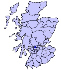
Strathkelvin is the strath (valley) of the River Kelvin in west central Scotland, lying north-east of Glasgow. The name Strathkelvin was used between 1975 and 1996 for one of nineteen local government districts in the Strathclyde region.

<span class="mw-page-title-main">Kirkintilloch</span> Human settlement in Scotland

Kirkintilloch is a town and former barony burgh in East Dunbartonshire, Scotland. It lies on the Forth and Clyde Canal and on the south side of Strathkelvin, about 8 miles (13 km) northeast of central Glasgow. Historically part of Dunbartonshire, the town is the administrative home of East Dunbartonshire council area, its population in 2009 was estimated at 19,700 and its population in 2011 was 19,689.

<span class="mw-page-title-main">Cumbernauld, Kilsyth and Kirkintilloch East (UK Parliament constituency)</span> Parliamentary constituency in the United Kingdom, 2005 onwards

Cumbernauld, Kilsyth and Kirkintilloch East is a constituency of the House of Commons of the Parliament of the United Kingdom. It was created for the 2005 general election, replacing Cumbernauld and Kilsyth and part of Strathkelvin and Bearsden.

<span class="mw-page-title-main">Lenzie</span> Human settlement in Scotland

Lenzie is a town by the Edinburgh and Glasgow Railway in the East Dunbartonshire council area of Scotland. It is about 6 miles (10 km) north-east of Glasgow city centre and 1 mile (2 km) south of Kirkintilloch. At the 2011 census, it had a population of 8,873. The ancient barony of Lenzie was held by William de Comyn, Baron of Lenzie and Lord of Cumbernauld in the 12th century.

Andrew Roger Henderson is a Scottish rugby union footballer who played at centre; who was capped 53 times and scored eight tries for Scotland.

<span class="mw-page-title-main">Lenzie railway station</span> Railway station in East Dunbartonshire, Scotland

Lenzie railway station is a railway station serving Lenzie and Kirkintilloch in East Dunbartonshire, Scotland. It is located on the Croy Line, 6+14 miles (10.1 km) northeast of Glasgow Queen Street. Trains on the Glasgow to Edinburgh via Falkirk Line pass Lenzie by. The station is served by ScotRail.

<span class="mw-page-title-main">Bishopbriggs railway station</span> Railway station in East Dunbartonshire, Scotland

Bishopbriggs railway station is a railway station serving Bishopbriggs in East Dunbartonshire, Scotland. It is located on the Glasgow to Edinburgh via Falkirk Line, 3+14 miles (5.2 km) north of Glasgow Queen Street, but is currently only served by services on the Croy Line.

<span class="mw-page-title-main">Demographics of Scotland</span>

The demography of Scotland includes all aspects of population, past and present, in the area that is now Scotland. Scotland had a population of 5,463,300 in 2019. The population growth rate in 2011 was estimated as 0.6% per annum according to the 2011 GROS Annual Review.

<span class="mw-page-title-main">History of the Jews in Scotland</span> History of Jews in the Scotland

The history of the Jews in Scotland goes back to at least the 17th century. It is not known when Jews first arrived in Scotland, with the earliest concrete historical references to a Jewish presence in Scotland being from the late 17th century. Most Scottish Jews today are of Ashkenazi background who mainly settled in Edinburgh, then in Glasgow in the mid-19th century. In 2013 the Edinburgh Jewish Studies Network curated an online exhibition based on archival holdings and maps in the National Library of Scotland exploring the influence of the community on the city.

<span class="mw-page-title-main">Auchinloch</span> Village in North Lanarkshire, Scotland

Auchinloch is a village in Scotland, situated within the North Lanarkshire local authority area but very close to the boundary with East Dunbartonshire and sharing the G66 postcode of the town of Kirkintilloch and the adjoining village of Lenzie, located a short distance to the north. Other nearby settlements in North Lanarkshire are Stepps to the south and Chryston to the south-east, each approximately 1.3 miles (2.1 km) away across farmland and on the opposite side of the M80 motorway; the Glasgow City council area boundary and the suburb of Robroyston is about the same distance to the west. In previous years Auchinloch was in the Parish of Cadder and, from 1975 until 1996, the district of Strathkelvin within Strathclyde Region.

<span class="mw-page-title-main">Islam in Scotland</span> Overview of Islam, Islamic culture and Muslims in Scotland

Islam in Scotland includes all aspects of the Islamic faith in Scotland. The first Muslim known to have been in Scotland was a medical student who studied at the University of Edinburgh from 1858 to 1859. The production of goods and Glasgow's busy port meant that many lascars were employed there. Most Muslims in Scotland are members of families that immigrated in the later decades of the 20th century. At the 2011 census, Muslims comprised 1.4 per cent of Scotland's population (76,737).

<span class="mw-page-title-main">Lenzie Academy</span> Comprehensive school in Lenzie, Scotland

Lenzie Academy is a co-educational comprehensive secondary school located in Lenzie, East Dunbartonshire, Scotland. The catchment area covers Lenzie, Auchinloch and southern parts of Kirkintilloch.

<span class="mw-page-title-main">Muirhead, North Lanarkshire</span> Human settlement in Scotland

Muirhead is a small town approximately 7 miles (11 km) north-east of Glasgow city centre. Nearby villages and towns include Chryston, Garnkirk, Gartcosh, Moodiesburn, Lenzie and Stepps. Muirhead has a population of around 1,390. It is a commuter town to Glasgow with road links with the A80/M80 and frequent bus services the 37c x35, x37, and x3. Muirhead is located approximately two miles from Gartcosh, Lenzie and Stepps railway stations.
<span class="mw-page-title-main">Cumbernauld</span> Town in North Lanarkshire, Scotland

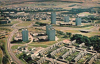
Cumbernauld is a large town in the historic county of Dunbartonshire and council area of North Lanarkshire, Scotland. It is the tenth most-populous locality in Scotland and the most populated town in North Lanarkshire, positioned in the centre of Scotland's Central Belt. Geographically, Cumbernauld sits between east and west, being on the Scottish watershed between the Forth and the Clyde; however, it is culturally more weighted towards Glasgow and the New Town's planners aimed to fill 80% of its houses from Scotland's largest city to reduce housing pressure there.

Lenzie Moss is a local nature reserve in Lenzie, East Dunbartonshire, Scotland. It is a boggy, marshy area that has not been built on. The reserve comprises lowland raised bogs, which were extensively exploited for peat, and now feature the characteristics of peat cutting, and several acres of deciduous woodland mainly made up of silver birch. The area is a sanctuary for wildlife, including rabbits, deer and foxes.

David Rollo was a Scottish nationalist political activist.
<span class="mw-page-title-main">Demographics of Glasgow</span> Demographics of the most populous city in Scotland

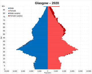
Glasgow is the most populous city in Scotland and the fourth most populous city in the United Kingdom.

Mid Dunbartonshire is a proposed constituency of the House of Commons in the UK Parliament. Further to the completion of the 2023 Periodic Review of Westminster constituencies, it will first be contested at the next general election.

References