Camp Verde is a town in Yavapai County, Arizona, United States. As of the 2010 census, the population of the town is 10,873.

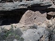
Montezuma Castle National Monument protects a set of well-preserved dwellings located in Camp Verde, Arizona, which were built and used by the Sinagua people, a pre-Columbian culture closely related to the Hohokam and other indigenous peoples of the southwestern United States, between approximately AD 1100 and 1425. The main structure comprises five stories and about 20 rooms and was built over the course of three centuries.
Fort Verde State Historic Park in the town of Camp Verde, Arizona is a small park that attempts to preserve parts of the Apache Wars-era fort as it appeared in the 1880s. The park was established in 1970 and was added to the National Register of Historic Places a year later.

The Yavapai–Apache Nation is a federally recognized Native American tribe in the Verde Valley of Arizona. Tribal members share two culturally distinct backgrounds and speak two indigenous languages, the Yavapai language and the Western Apache language. The Yavapai–Apache Nation Indian Reservation, at 34°37′10″N111°53′46″W, consists of five non-contiguous parcels of land located in three separate communities in eastern Yavapai County. The two largest sections, 576 acres (233 ha) together – almost 90 percent of the reservation's territory, are in the town of Camp Verde. Smaller sections are located in the town of Clarkdale 60.17 acres (24.35 ha), and the unincorporated community of Lake Montezuma. The reservation's total land area is 642 acres (260 ha). The total resident population of the reservation was 743 persons as of the 2000 census. The 2010 Census reported 1,615 people on the reservation. Of these, 512 lived in Camp Verde, 218 in Clarkdale, and only 13 in Lake Montezuma.

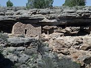
Walnut Canyon National Monument is a United States National Monument located about 10 mi (16 km) southeast of downtown Flagstaff, Arizona, near Interstate 40. The canyon rim elevation is 6,690 ft (2,040 m); the canyon's floor is 350 ft lower. A 0.9 mi (1.4 km) long loop trail descends 185 ft (56 m) into the canyon passing 25 cliff dwelling rooms constructed by the Sinagua, a pre-Columbian cultural group that lived in Walnut Canyon from about 1100 to 1250 AD. Other contemporary habitations of the Sinagua people are preserved in the nearby Tuzigoot and Montezuma Castle national monuments.

The Sinagua were a pre-Columbian culture that occupied a large area in central Arizona from the Little Colorado River, near Flagstaff, to the Verde River, near Sedona, including the Verde Valley, area around San Francisco Mountain, and significant portions of the Mogollon Rim country, between approximately 500 and 1425 CE.

Montezuma Well, a detached unit of Montezuma Castle National Monument, is a natural limestone sinkhole near the town of Lake Montezuma, Arizona, through which some 1,500,000 US gallons of water emerge each day from an underground spring. It is located about 11 miles (18 km) northeast of Montezuma Castle.
Fort Lowell was a United States Army post active from 1873 to 1891 on the outskirts of Tucson, Arizona. Fort Lowell was the successor to Camp Lowell, an earlier Army installation. The Army chose a location just south of the confluence of the Tanque Verde and Pantano creeks, at the point where they form the Rillito River, due to the year-round supply of water during that period. The Hohokam natives had chosen the site centuries earlier, presumably for the same reason. To this day, shards of Hohokam pottery can still be found in the area. The Army claimed a military reservation that encompassed approximately eighty square miles and extended east toward the Rincon Mountains.

Fort McDowell is an unincorporated community in Maricopa County, Arizona, United States. Fort McDowell is 23 miles northeast of Phoenix. Fort McDowell has a post office with ZIP code 85264.

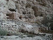
The Honanki Heritage Site is a cliff dwelling and rock art site located in the Coconino National Forest, about 15 miles (24 km) west of Sedona, Arizona. The Sinagua people of the Ancestral Puebloans, and ancestors of the Hopi people, lived here from about 1100 to 1300 CE. The Palatki Heritage Site is nearby, also in the Coconino National Forest.

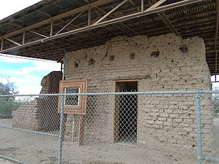
Tuzigoot National Monument preserves a 2- to 3-story pueblo ruin on the summit of a limestone and sandstone ridge just east of Clarkdale, Arizona, 120 feet (37 m) above the Verde River floodplain. The Tuzigoot Site is an elongated complex of stone masonry rooms that were built along the spine of a natural outcrop in the Verde Valley. The central rooms stand higher than the others and they appear to have served public functions. The pueblo has 110 rooms. The National Park Service currently administers 58 acres, within an authorized boundary of 834 acres.

Fort Apache Historic Park is a tribal historic park of the White Mountain Apache, located at the former site of Fort Apache on the Fort Apache Indian Reservation. The park interprets the rich and troubled history of relations between the Apache and other Native American tribes at the fort, which was converted into a Bureau of Indian Affairs boarding school after its military use ended. The park, which covers 288 acres (117 ha) of the former fort and school, as well as a nearby military cemetery, form the National Historic Landmark Fort Apache and Theodore Roosevelt School historic district.


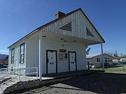
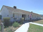 The Fort Verde Administration Building.
 Inside the Commanding Officers Office in the Administration Building.
 7th Cavalry Bugle
 Display of uniforms in the Administration Building.
 Buffalo soldiers exhibit
 Military hats worn in Fort Verde
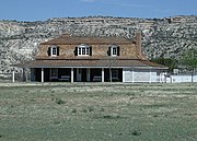 The Commanding Officer Quarters
 The Bachelor Officers’ Quarters.
 The Doctor’s & Surgeons Quarters.
 The George Hance House.