List of historic properties in Queen Creek, Arizona

Last updated

List of historic properties
in Queen Creek, Arizona
Queen Creek-Schnepf Farms-Schnepf House-1900-2.jpg
The Schnepf House
AZMap-doton-Queen Creek.png
Location in Maricopa County and the state of Arizona

This is a list, which includes a photographic gallery, of some of the structures of historic significance in Queen Creek, Arizona. Part of the town is located in Maricopa County and the other part in Pinal County.

Contents

History

The Valley below the San Tan Mountains had fertile lands. This attracted the Hohokam, a Native American tribe, who were the first to establish communities in the area. The homesteaders then arrived and began to establish farms and ranches along what was called the Queen Creek Wash. [1]

In 1924, Charles Rittenhouse, a land developer, established the Queen Creek Farms Company. The wells in his company pumped 2,150 gallons of water per minute, which helped make his 1,000 acres of land very productive. A railroad was soon established in the area and a small town grew around the railroad where it could ship the produce and cotton which grew in the farms. The town was called Rittenhouse because the Railroad ran near Rittenhouse and Ellsworth roads. The residents of the area, wanting to travel to Phoenix by train, would often flag down the train to get a ride.

In the eastern part of Arizona there is a mountain where the Silver King Mine is located. There is a creek at the base of the mountain which was called Picket Post Creek. Eventually the creeks name was changed to Queen Creek. The creek ran from the mountain and into the area of Rittenhouse.

It wasn't long before the farmers began to rely more on the use of automobiles and trucks than on the railroad. The use of the railroad declined and the people began to call and identify the area as Queen Creek. [2] The town's name officially was changed to Queen Creek in 1947, with the establishment of the Queen Creek Post Office. The town, which was incorporated in 1989, has the unique distinction of having part of the town located within Maricopa County and another part within Pinal County. [3]

Immigrants from Mexico moved into the area and picked the local cotton crop by hand until the 1920s when the cotton gin came to Queen Creek. In the 1940s the United States set up a German prisoner-of-war camp by Rittenhouse Road. The prisoners, together with immigrants from the Philippines, worked as farm laborers in local fields. [1]

In 1990, members of the community established the San Tan Historical Society. The mission of the society is to preserve the area's heritage. The society collects, preserves, documents, and displays the histories and artifacts of the Chandler Heights, Combs, Higley, and Queen Creek Communities. There are various properties in the town of Queen Creek which are considered historical and have been included either in the National Register of Historic Places or listed as such by the San Tan Historical Society. [4]

The Town of Queen Creek, however, lacks the authority to deny a demolition permit. Therefore, the owner of a property, listed either in the National Register of Historic Places or considered historical by the San Tan Historical Society, may demolish the historical property in question if they so desire. An example of this is the historic Water Tower which was built in 1952 for the Producers Cotton Gin. The water tower was to be demolished, but in 1999, the Schnepf family purchased it and moved it to the grounds of the Schnepf Farms. According to Jim McPherson, Arizona Preservation Foundation Board President: "It is crucial that residents, private interests, and government officials act now to save these elements of our cultural heritage before it is too late." [5]

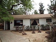
The historic Schnepf Farms is located five miles southeast of the town. The area was purchased by Jack and Maude Schnepf in 1941. They were among the first settlers to buy a cotton picker, put in cement ditches and dig sumps to catch and recycle wastewater. Jack and Raymond Schnepf invented and manufactured the aluminum irrigation tube. As neighboring farm owners sold their properties to developers, the Schnepf Family purchased unique farm buildings from these neighboring farms and incorporated them on the Schnepf Farm to preserve the history of these farms. [6]

List

Railroad Water Tank Queen Creek- Railroad Water Tank-1900-2.jpg
Railroad Water Tank

Also pictured is the gravesite of Mansel Carter and Marion E. Kennedy, located in what once was their campsite in Gold Mountain. The area is now within the boundaries of the San Tan Mountain Regional Park.

San Tan Mountain Regional Park

See also

Related Research Articles

<span class="mw-page-title-main">Litchfield Park, Arizona</span> City in Arizona, United States

Litchfield Park is a city in Maricopa County, Arizona, United States. It is located 19 miles (31 km) west of Phoenix. As of the 2020 census, the population of the city was 6,847, up from 5,476 in 2010.

<span class="mw-page-title-main">Queen Creek, Arizona</span> Town in Maricopa and Pinal counties, Arizona

Queen Creek is a town in Maricopa and Pinal counties, Arizona, United States. The population was 59,519 at the 2020 census. It is a suburb of Phoenix, located in the far southeast area of the Phoenix Metropolitan Area. A large battery factory is being constructed.

<span class="mw-page-title-main">Maricopa, Arizona</span> City in Arizona, United States

Maricopa is a city in the Gila River Valley in Pinal County, Arizona, United States. With 66,290 residents as of 2022, Maricopa is the largest incorporated municipality in Pinal County.

The metropolitan area of Phoenix in the U.S. state of Arizona contains one of the nation's largest and fastest-growing freeway systems, with over 1,405 lane miles (2,261 km) as of 2005.

Many arterial roads in the Phoenix metropolitan area have the same name in multiple cities or towns. Some roads change names or route numbers across town borders, resulting in occasional confusion. For example, the road known as Apache Boulevard in Tempe continues east as Main Street in neighboring Mesa and then as Apache Trail in Apache Junction. Although Broadway Road maintains the same name through Goodyear, Avondale, Phoenix, Tempe, Mesa, and Apache Junction, each town uses a different reference point for address numbers.

<span class="mw-page-title-main">Henry Wickenburg</span> Arizona pioneer and miner (1819–1905)

Henry Wickenburg was a Prussian prospector who discovered the Vulture Mine and founded the town of Wickenburg in the U.S. state of Arizona. Wickenburg never married. Mrs. Helene Holland inherited Wickenburg’s personal property in 1903, while he was still alive, and the remainder of his estate in 1905 after Henry Wickenburg died from a gunshot wound in the head. His death was deemed a suicide, but many questioned this ruling. The mine that he discovered produced as much as $70 million worth of gold during its course of operation, making it the most important gold mine in Arizona.

<span class="mw-page-title-main">Rittenhouse Elementary School</span> Historic school in Queen Creek, Maricopa County, Arizona,, now a museum

The Rittenhouse Elementary School, now the San Tan Historical Society Museum, is a well-preserved historic school located at 20425 South Ellsworth Road at the intersection with East Queen Creek Road in Queen Creek, Arizona. It was built from 1924 to 1925 in the Spanish Colonial Revival style, opened for classes in 1926, and closed in 1982, after which it was used for storage by the Queen Creek Unified School District.

<span class="mw-page-title-main">Pioneer and Military Memorial Park</span> United States historic place in Phoenix, Arizona

The Pioneer and Military Memorial Park is the official name given to seven historic cemeteries in Phoenix, Arizona. The cemeteries were founded in 1884 in what was known as "Block 32". On February 1, 2007, "Block 32" was renamed Pioneer and Military Memorial Park. The Pioneer and Military Memorial Park is listed in the National Register of Historic Places. The historic Smurthwaite House, which is also listed in the National Register of Historic Places, is located on the grounds of the Pioneer and Military Memorial Park and is used as the cemetery's main office. Pioneer and Military Memorial Park is the final resting place of various notable pioneers of Arizona.

<span class="mw-page-title-main">Mansel Carter</span> American businessman and prospector (1902–1987)

Mansel Carter, also known as "Man of the Mountain", was an American businessman and prospector. In 1987, The Phoenix named him one of "Arizona Legends". The San Tan Historical Society of Queen Creek recognized his gravesite at Gold Mountain in the San Tan Mountain Regional Park in Queen Creek, Arizona as a tourist attraction. In 2017, the town of Queen Creek named a new community park the "Mansel Carter Oasis Park" in his honor.

<span class="mw-page-title-main">San Tan Mountain Regional Park</span> Park in Pinal County, Arizona

San Tan Mountain Regional Park is a large rural/suburban park located in Pinal County. Although the park is administered by Maricopa County Parks, it is located within Pinal County. It encompasses over 10,000 acres and preserves a portion of the San Tan Mountains, south of Queen Creek.

<span class="mw-page-title-main">Sedona Schnebly</span> Arizona pioneer (1877–1950)

Sedona Schnebly was an early pioneer in the Oak Creek area of Arizona. She was the namesake of the town of Sedona, Arizona. She helped in the establishment of the family farm and general store in the town. She also served as the town's bible school teacher. Sedona saved funds to build the Wayside Chapel. Among her legacy is a sculpture of a statue in her likeness by the Sedona Red Rocks Arts Council honoring her memory.

References

Notes

Further reading