McKownville, New York

Last updated

McKownville
Etymology: for John McKown and family, early settlers from the late 18th century
USA New York location map.svg
Red pog.svg
McKownville
Location of McKownville
within the US state of New York
Coordinates: 42°40′45″N73°50′02″W / 42.67917°N 73.83389°W / 42.67917; -73.83389
CountryUnited States
State New York
Region Capital District
County Albany
Settledlate 18th century
Elevation
249 ft (76 m)
Population
 (1993 (appr.))
  Total2,756
Time zone UTC-5 (EST)
  Summer (DST) UTC-4 (EDT)
ZIP Code
12203
Area code 518

McKownville is a hamlet in the town of Guilderland, Albany County, New York, United States. It lies along the eastern border of the town with the city of Albany. McKownville is a heavily developed suburb of Albany and is home to many strip malls, shopping centers, and a portion of the University at Albany, SUNY and is bisected by U.S. Route 20 (Western Avenue). McKownville is named for John McKown and family, early settlers from the late 18th century.

Contents

History

In the 18th century the King's Highway, a series of paths through the Pine Bush pine barrens from Albany to Schenectady, passed through what would later become McKownville. In the late 1740s, John McKown, originally from Scotland, moved his family to the United States of America from County Londonderry, Ireland. [1] [n 1] He leased the Five Mile Tavern along the King's Highway, near the present-day Indian Quad of the University at Albany, SUNY.

In 1790, his son William built a tavern at the corners of what would later be Fuller Road and Western Avenue. The first post office (1884) was in this tavern, today the site of a Burger King. The family would, over time, buy the majority of the land in what is now the hamlet named for them. They would donate land for the construction of the Great Western Turnpike built in 1799 (today Western Avenue), land for a local church (McKownville Methodist Church), and the original one room school house. The McKownville School District No. 11 was built around 1877, with a second one-room house (McKownville Annex School No. 11-A) built in 1887. Both were closed in 1953 and replaced by the Westmere Elementary School when the district was consolidated into the Guilderland Central School District. [1]

In 1896, the Albany Country Club and Golf Course was built, straddling the Albany-Guilderland border which demolished remnants of the old King's Highway. The country club would be replaced by the University at Albany, SUNY (SUNYA) Uptown Campus in the 1960s. [1] Though the university is a part of the identity of McKownsville, the relationship has at times been strained regarding the growth of the campus and its impacts on adjacent residential areas. [2] [3]

Being along Albany's city line, McKownville has long been a center of suburban development including residential, commercial/office, retail, and educational. Strip malls, fast food, hotels, and other retail line Western Avenue, including Stuyvesant Plaza which was the first suburban shopping plaza built outside the city border. In 1924, residents formed the McKownville Improvement Association to lobby the town to build sidewalks and a create a water district for the neighborhood. It continued to fight for smart-growth and opposed the building of Crossgates Mall and its subsequent additions. [4] In 2004, the association's push for sidewalks finally came to fruition. [5] One of the additions to Crossgates that the association was worried about was a 1998 proposal by owner Pyramid Companies that would have included a 12 story tall hotel, ice skating rink, miniature golf course, and an additional 2,000,000 square feet (190,000 m2) of retail space to its already 1 million square feet. [6] [7] The expansion was dealt a serious blow when the McKownville United Methodist Church, which was an important piece of real estate for the expansion, refused to sell. [6] The expansion would have made Crossgates the largest mall in the nation, but due to opposition from Guilderland the plan was dropped and later retooled for Syracuse's Destiny USA.

In 2002, it was found that in the 2000 Census 1,357 students at the Indian Quad dorms of SUNYA counted as part of Albany were actually in the town of Guilderland. Albany Mayor Jerry Jennings then refused to allow EMS and fire response from the city to cover Indian Quad and the Recreation and Convocation Center (today the SEFCU Arena), both in Guilderland. This caused a dispute between Mayor Jennings, who demanded payment from the town for $37,600 in past calls that the city responded to since 1999, and Ken Runion (Guilderland town supervisor) who claimed that Albany owed $363,000 that the city received from county sales taxes in 2001 that are based on population and included the Indian Quad. [8]


Geography

As a hamlet, the boundaries of McKownville are ill-defined, though generally considered to be the Governor Thomas E. Dewey Thruway (Interstate 87) and Fuller Road Alternate (unsigned NY Route 910F) to the west, the town of Bethlehem to the south, and the city of Albany to the east and north. [9] Once a part of the Albany Pine Bush, it is mostly flat or very gently rolling hills. The Krum Kill marks the eastern border with Albany. [1]

Location

Demographics

As a hamlet McKownville has no definitive boundaries and therefore it is difficult to have statistics on the population. It was estimated by the Albany Times Union in 1993 that there are approximately 2,756 persons with 1,137 housing units in the hamlet. [4]

Education

McKownville is a part of the Guilderland Central School District (GCSD) and the children attend Westmere Elementary School for kindergarten through 5th grade; and Farnsworth Middle School for 6th through 8th grade; and Guilderland High School for 9th through 12th. [4]

McKownville Fire Department

McKownville has its own fire department which was formed in 1918. The McKownville Fire Department is 100% volunteer and responds to approximately 250-300 calls for service a year. The Department currently operates with two pumpers, one rescue truck, two command vehicles and a utility vehicle.

Notes

  1. County Londonderry is today in Northern Ireland, a part of the United Kingdom (UK). At the time John McKown lived there it was part of the Kingdom of Ireland, which was in personal union with the UK.

Related Research Articles

<span class="mw-page-title-main">Albany, New York</span> Capital city of New York, United States

Albany is the capital city of the U.S. state of New York and the seat of Albany County. It is located on the west bank of the Hudson River, about 10 miles (16 km) south of its confluence with the Mohawk River, and about 135 miles (220 km) north of New York City.

<span class="mw-page-title-main">Guilderland, New York</span> Town in New York, United States

Guilderland is a town in Albany County, New York, United States. In the 2020 census, the town had a population of 36,848. The town is named for the Gelderland province in the Netherlands. The town of Guilderland is on the central-northwest border of the county. It is just west of Albany, the capital of the U.S. state of New York.

<span class="mw-page-title-main">Westmere, New York</span> Hamlet in New York, United States

Westmere is a hamlet in the town of Guilderland, Albany County, New York, United States. Since the 1970 Census, a census-designated place (CDP) has been established with the name of Westmere for tabulating the population of what the census has defined as the boundaries for Westmere. The population was 7,284 at the 2010 census. It is a suburb of the neighboring city of Albany. U.S. Route 20 bisects the community and is the major thoroughfare and main street. Along Western Avenue are numerous strip malls, shopping plazas, and commercial buildings, with residential use on the side streets to the north and south. Crossgates Mall, the Capital District's largest shopping mall, is in Westmere's northeastern corner.

<span class="mw-page-title-main">Albany Pine Bush</span> Pine barren in Albany, New York

The Albany Pine Bush, referred to locally as the Pine Bush, is one of the largest of the 20 inland pine barrens in the world. It is centrally located in New York's Capital District within Albany and Schenectady counties, between the cities of Albany and Schenectady. The Albany Pine Bush was formed thousands of years ago, following the drainage of Glacial Lake Albany.

<span class="mw-page-title-main">SEFCU Arena</span> Multi-purpose arena in Guilderland, New York

The Broadview Center, formerly known as the SEFCU Arena, is a 4,538-seat multi-purpose arena in Guilderland, New York. It is home to the University at Albany men's and women's Great Danes basketball teams. It is most notable for hosting the 2006 America East Conference men's basketball tournament championship, in which the Great Danes defeated Vermont, to earn their first bid into the NCAA Men's Division I Basketball Championship. The arena additionally hosted the 2009 America East men's basketball tournament, and is also a venue for the university's graduate commencement ceremonies. It can also can be formatted as a concert venue or to accommodate trade shows and conventions.

Crossgates Mall is an enclosed, automobile-oriented, super-regional shopping mall located in the Albany, New York suburb of Guilderland. It is the largest indoor shopping center in the Capital District, and the third largest in the State of New York. The mall featutes the traditional retailers Macy's, JCPenney, Dick's Sporting Goods, Primark, Burlington, Best Buy, and REI. The mall features the prominent specialty retailers Urban Outfitters, Lululemon Athletica, Zara, Dry Goods, and Offline by Aerie.

<span class="mw-page-title-main">New York State Route 155</span> State highway in Albany County, New York, US

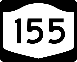
New York State Route 155 (NY 155) is a 16.85-mile-long (27.12 km) state highway located entirely within Albany County in the Capital District of New York. The western terminus of the route is at NY 85A in Voorheesville. The eastern terminus is at NY 32 in Watervliet. NY 155 mainly serves as a connection to the Albany International Airport from the major roads it connects to.

Guilderland Center is a hamlet in the town of Guilderland, Albany County, New York, United States. The hamlet lies along New York Route 146 and the Black Creek, a tributary of the Normans Kill.

Slingerlands is a hamlet in the town of Bethlehem, Albany County, New York, United States. It is located immediately west of Delmar and near the New Scotland town-line and south of the Albany city-limits, and is thus a suburb of Albany. The Slingerlands ZIP Code (12159) includes parts of the towns of New Scotland and Guilderland.

<span class="mw-page-title-main">Neighborhoods of Albany, New York</span>

The neighborhoods of Albany, New York are listed below.

The history of Albany, New York began long before the first interaction of Europeans with the native Indian tribes, as they had long inhabited the area. The area was originally inhabited by an Algonquian Indian tribe, the Mohican, as well as the Iroquois, five nations of whom the easternmost, the Mohawk, had the closest relations with traders and settlers in Albany.

<span class="mw-page-title-main">Streets of Albany, New York</span> Streets of Albany, New York

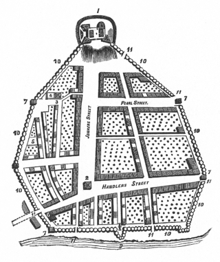
The streets of Albany, New York have had a long history going back almost 400 years. Many of the streets have changed names over the course of time, some have changed names many times. Some streets no longer exist, others have changed course. Some roads existed only on paper. The oldest streets were haphazardly laid out with no overall plan until Simeon De Witt's 1794 street grid plan. The plan had two grids, one west of Eagle Street and the old stockade, and another for the Pastures District south of the old stockade.

Guilderland is a hamlet of the town of the same name in Albany County, New York, United States.

Fullers is a hamlet in the town of Guilderland, Albany County, New York, United States. The hamlet lies along U.S. Route 20.

<span class="mw-page-title-main">Albany Convention Center</span>

The Albany Convention Center (ACC) was a proposed convention center to be located in downtown Albany, New York. The complex was initially proposed by Albany Mayor Gerald Jennings in 1994. In 2004, the Albany Convention Center Authority (ACCA) was established by the New York Legislature as a New York State public-benefit corporation to develop plans for the ACC. Supported by Governor George Pataki, the project was awarded a $75 million grant in 2006. The anticipated price tag of the project was approximately $220 million, and a site between Broadway, Hudson Avenue, and the South Mall Arterial was selected. In 2008, 2009, and 2010, the ACCA acquired much of the property that made up the proposed site.

<span class="mw-page-title-main">Architecture of Albany, New York</span>

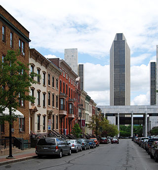
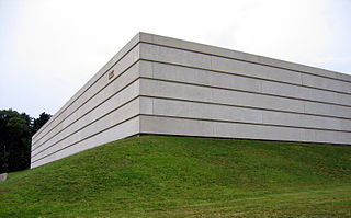
The architecture of Albany, New York, embraces a variety of architectural styles ranging from the early 18th century to the present. The city's roots date from the early 17th century and few buildings survive from that era or from the 18th and early 19th century. The completion of the Erie Canal in 1825 triggered a building boom, which continued until the Great Depression and the suburbanization of the area afterward. This accounts for much of the construction in the city's urban core along the Hudson River. Since then most construction has been largely residential, as the city spread out to its current boundaries, although there have been some large government building complexes in the modernist style, such as Empire State Plaza, which includes the Erastus Corning Tower, the tallest building in New York outside of New York City.

Pine Hills is a neighborhood in Albany, New York, generally defined as the area from Manning Boulevard to the west, Woodlawn Avenue to the south, Lake Avenue to the east, and Washington Avenue to the north. The neighborhood consists mainly of freestanding multi-unit, duplex, and semi-detached houses and is home to Albany High School, the LaSalle school, the College of St. Rose, and the Alumni Quad of the University at Albany. Though mostly residential due to historical reasons from its founding, Pine Hills is home to two neighborhood commercial districts ; Middle Madison, from Partridge to Quail streets was designated first, and then a latter designated district, Upper Madison, from Main Avenue to North Allen Street. The area of Pine Hills east of Main Avenue and north of Myrtle Avenue is commonly referred to as the student ghetto due to its predominant population of college-age students. The area of Pine Hills west of Main Avenue features many large Queen Anne, Folk Victorian, and Colonial Revival homes. Upper Madison, where it meets Western Avenue near St. Rose is the center of a commercial area, complete with a movie theater, grocery store, fast food strip mall, retail, restaurants, a library, community playhouse, police station, pharmacy, and elementary school.

<span class="mw-page-title-main">History of Albany, New York (1860–1900)</span>

The history of Albany, New York from 1860 to 1900 begins in 1860, prior to the start of the Civil War, and ends in 1900.

Washington Avenue is a major east–west route in the city of Albany, New York.

<span class="mw-page-title-main">Disappearance of Suzanne Lyall</span> 1998 missing person case

References

  1. 1 2 3 4 Alice Begley & Mary Ellen Johnson (1999). Guilderland, New York. Arcadia Publishing. pp. 9–21. ISBN   0-7385-0112-3 . Retrieved February 14, 2010.
  2. Spofford, Tim (August 15, 1989). "McKownville Residents Face SUNYA Growth". Times Union (Albany). Hearst Newspapers. p. B3. Retrieved February 14, 2010.
  3. Anderson, Eric; Chris Churchill & Larry Rulison (March 22, 2009). "Watch Out, McKownville". Times Union (Albany). Hearst Newspapers. p. E1. Retrieved February 14, 2010.
  4. 1 2 3 Ingraham, Frances (January 17, 1993). "Residential Life in Mercantile McKownville". Times Union (Albany). Hearst Newspapers. p. G1. Retrieved February 14, 2010.
  5. Miller, Anne (September 25, 2004). "Hamlet Wins Sidewalks After 80 Years". Times Union (Albany). Hearst Newspapers. p. B1. Retrieved February 14, 2010.
  6. 1 2 Snyder, James G. (November 11, 2000). "Church to Discuss its Role in Mall Plan". Times Union (Albany). Hearst Newspapers. p. B14. Retrieved February 14, 2010.
  7. Martineau, Kimberly (July 9, 1998). "Hotel to Make Crossgates Tourist Spot, Developer Says". Times Union (Albany). Hearst Newspapers. p. B1. Retrieved February 15, 2010.
  8. Duggan, Erin (December 12, 2002). "Census Spurs Money Dispute". Times Union (Albany). Hearst Newspapers. p. A1. Retrieved February 14, 2010.
  9. Dieffenbach, John (September 9, 1987). "A Hamlet in Search of its Identity McKownville Longing for Homey Spirit". Knickerbocker News (Albany). Hearst Newspapers. p. 4A. Retrieved February 14, 2010.