West Albany, New York

Last updated
West Albany
Etymology: for being west of the city of Albany
USA New York location map.svg
Red pog.svg
West Albany
Location of West Albany within the state of New York
Coordinates: 42°41′10″N73°47′05″W / 42.68611°N 73.78472°W / 42.68611; -73.78472 Coordinates: 42°41′10″N73°47′05″W / 42.68611°N 73.78472°W / 42.68611; -73.78472
Country United States
State New York
Region Capital District
County Albany
Settled1850s
Time zone UTC-5 (EST)
  Summer (DST) UTC-4 (EDT)
ZIP Code
12205
Area code(s) 518

West Albany is a hamlet in the town of Colonie, Albany County, New York. Parts of the neighboring city of Albany around Watervliet Avenue Extension and Industrial Park Road are also considered part of West Albany and includes the majority of the West Albany Rail Yard. The hamlet lies along Albany's northern border and was once home to many industries including one of the largest cattle stockyards in the United States, a large railroad switching yard, and a Tobin First Prize packing plant. Those industries are gone now and the community is mostly a residential suburb of Albany in the shadow of abandoned industrial complexes. West Albany has historically been ethnically diverse with Polish, Italian, Irish, German, and English immigrants drawn by the 5,000+ jobs at the West Albany Rail Yard. [1] Though the neighborhood is predominately Italian-American, [1] it remains diverse with the Polish American Citizens Club, the West Albany Italian Benevolent Society, the Bet Shraga Hebrew Academy, and a Korean worship center in the former St. Francis de Sales Catholic Church.

Contents

History

Andrew R. Hunter purchased in the 1850s extensive holdings in what would become West Albany, improving and surveying lots that he would then subsequently sell to homesteaders. He is credited with making West Albany. [2]

Though Hunter is credited with settling West Albany it is to industry that credit must be given for making West Albany a name in the world. The cattle stockyards were moved here from Albany in 1860 and quickly rose to national importance, ranking just behind Chicago and Buffalo at the end of the 1880s, and occasionally even surpassing them in business transacted. Growth in the hamlet accelerated due to the presence of the railroads, stockyards, meat packing and related industries. A post office was established in 1862 and in 1865 the horse railway (an early form of mass transit) was extended up Central Ave from downtown Albany to West Albany. [3]

Engine 999 as it leads the Empire State Express through Palatine, New York in 1905. NYC 999.jpg
Engine 999 as it leads the Empire State Express through Palatine, New York in 1905.

The location of the cattle yards and the subsequent development of West Albany would not have been possible without the railroads. In 1844 the railroad between Albany and Schenectady east of Fuller Road was moved north from the central part of the city to the Tivoli Hollow Line which ran across the northern border of the city along Patroon Creek and through West Albany. The Albany & Schenectady Railroad which owned this line was merged with nine other railroads as the New York Central Railroad (NYC) in 1853; [4] and work soon began on the establishment of a large rail yard, on 250 acres (1.0 km2) purchased in 1854 in West Albany. It would later be expanded to include another 100 acres (0.40 km2). [5] The NYCRR shops at the West Albany Yard employed over 6,000 people at its height at the turn of the 20th century. In 1893 those shops built Engine 999 as a special publicity project in order to win an international competition to build the world's fastest steam locomotive. Engine #999 won at 102.8 miles per hour, [6] the first time the 100 mile/hour mark was reached by a locomotive. [7] Today the engine is on display at the Museum of Science and Industry in Chicago. [7] About the same time as Engine 999 was being built locomotive construction was starting to be outsourced to the American Locomotive Company (ALCO) in nearby Schenectady, and the last steam engine to be repaired at the West Albany Shops would be in 1952, with the train car repair shops closing in 1954. [6] [8] The site was sold in 1955, equipment auctioned in 1956, and the majority of the buildings were demolished in 1964. The West Albany Industrial Park in the city of Albany occupies most of the site today and there remains a small freight car operation. The main track continues to be used by freight and Amtrak passenger trains. [8]

West Albany sat at the center of a railroad crossroads where the road west from New England met the road coming north from New York City for traffic to travel west. This became a sore bottleneck for the NYC due to the West Albany Hill being the steepest grade between the East Coast and Chicago. [9] By 1922, the large grade and other inadequacies of the West Albany Yard, along with issues concerning the low drawbridges across the Hudson River leading to it, led to the building of the Castleton Cutoff, including the Alfred H. Smith Memorial Bridge and the Selkirk Yard. Trains could now bypass the entire city of Albany. [10]

The slaughterhouse roots of West Albany continued into the later half of the 20th century, decades after the railroad abandoned hamlet, thanks to the Tobin Packing Company. In 1924, the Albany Packing Company was incorporated, and it would later merge with the Rochester Packing Company to form the Tobin Packing Company. Tobin's First Prize continues to be one of the most top-selling brands in the Northeastern U.S., and especially Albany, according to the current owner of the brand, John Morrell and Company. [11] The plant, also referred to as Tobin's First Prize Center, was according to former employees so busy it pumped out 50,000 hot dogs, 700 hams, and 20,000 pounds of kielbasa a day; and every hour roughly 360 hogs were slaughtered to keep up with this production. [12] When the Tobin meat-packing plant closed in 1981, it employed 600 people. [13] The First Prize Center has seen interest from several different retail development plans, including at one point or another either a Walmart, Kmart (which backed away when it filed for bankruptcy), Home Depot (which decided to build on the other side of Interstate 90 on Central Ave in Albany), or Lowe's. [14] The site was even considered for a new county nursing home. [15] The Albany County Industrial Development Agency (IDA) has owned the 32-acre (130,000 m2) property since the late 1980s after purchasing it from the US Federal Government foreclosure sale. [14] [15]

With the loss of the rail yard and Tobin's the community began somewhat of a decline, at least as measured by enrollment in the West Albany Elementary School. In 1984, the school was closed after years of declining enrollment. This school has its origins as the West Albany Union Free School 19 which was established in 1857, and in 1947 the district was consolidated with others in the town of Colonie to form the South Colonie Central School District. The building continues to be used for educational purposes as the home of a Hebrew Academy.

Geography

West Albany is in the southern part of the town of Colonie, along the border with Albany. Like all hamlets in New York, West Albany is very loosely defined geographically. Portions of the hamlet have been annexed to the neighboring city of Albany, but still identify as West Albany. Exchange Street is considered to be main street, though Everett Road (Albany County Route 155) and Sand Creek Road are more important thoroughfares. Recent suburbanization of the former farms and woodlands surrounding West Albany has further blurred the identity of West Albany and eliminated any buffer from neighboring hamlets such as Loudonville and Roessleville.

Location

Related Research Articles

Schenectady, New York City in New York, United States

Schenectady is a city in Schenectady County, New York, United States, of which it is the county seat. As of the 2010 census, the city had a population of 66,135. The name "Schenectady" is derived from the Mohawk word skahnéhtati, meaning "beyond the pines". Schenectady was founded on the south side of the Mohawk River by Dutch colonists in the 17th century, many of whom were from the Albany area. The Dutch transferred the name "Skahnéhtati" which is in reality the Mohawk name for Albany, New York. These Dutch were prohibited from the fur trade by the Albany monopoly, which kept its control after the English takeover in 1664. Residents of the new village developed farms on strip plots along the river.

Green Island, New York Town and village in New York, United States

Green Island is a coterminous town-village in Albany County, New York, United States some 8 miles (13 km.) north of Albany, New York. Green Island is one of only five such town-village amalgams in New York. The population was 2,620 at the 2010 census, and the postal code is 12183. While the town of Green Island was once an island, it was connected to the mainland on the west side of the Hudson River in the 1960s.

Colonie, New York Town in New York, United States

Colonie is a town in Albany County, New York, United States. It is the most populous suburb of Albany, New York, and is the third largest town in area in Albany County, occupying about 11% of the county. Several hamlets exist within the town. As of the 2010 census, the town had a total population of 81,591.

Capital District, New York Region in New York, United States

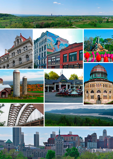
The Capital District, also known as the Capital Region, is the metropolitan area surrounding Albany, the capital of the U.S. state of New York. In the 21st century, the Capital District emerged as a major anchor of Tech Valley, the moniker describing the technologically-focused region of eastern New York State. The Capital District was first settled by the Dutch in the early 17th century and came under English control in 1664. Albany has been the permanent capital of the state of New York since 1797. The Capital District is notable for many historical events that predate the independence of the United States, including the Albany Plan of Union and The Battles of Saratoga.

Fort Worth Stockyards United States historic place

The Fort Worth Stockyards is a historic district that is located in Fort Worth, Texas, north of the central business district. A 98-acre (40 ha) portion encompassing much of the district was listed on the National Register of Historic Places as Fort Worth Stockyards Historic District in 1976. It holds a former livestock market which operated under various owners from 1866.

Union Stock Yards Meatpacking district of Chicago

The Union Stock Yard & Transit Co., or The Yards, was the meatpacking district in Chicago for more than a century, starting in 1865. The district was operated by a group of railroad companies that acquired marshland and turned it into a centralized processing area. By the 1890s, the railroad capital behind the Union Stockyards was Vanderbilt money. The Union Stockyards operated in the New City community area for 106 years, helping Chicago become known as the "hog butcher for the world" and the center of the American meatpacking industry for decades.

Albany Pine Bush

The Albany Pine Bush, referred to locally as the Pine Bush, is one of the largest of the 20 inland pine barrens in the world. It is centrally located in New York's Capital District within Albany and Schenectady counties, between the cities of Albany and Schenectady. The Albany Pine Bush was formed thousands of years ago, following the drainage of Glacial Lake Albany.

Latham, New York Hamlet and CDP in New York, United States

Latham is a hamlet in Albany County, New York, United States. It is located along U.S. Route 9 in the town of Colonie, a dense suburb north of Albany. As of the 2010 census, the population was 20,736. Latham was a census-designated place in the 1970, 1980, and 1990 US Census, but ceased to be in the 2000 Census, but became a CDP again in 2020.

Crescent Station, New York Hamlet in New York, United States

Crescent Station is a hamlet of the town of Colonie in Albany County, New York that straddles US Route 9.

Dunsbach Ferry, New York hamlet in New York, United States

Dunsbach Ferry is a hamlet of the town of Colonie, in Albany County, New York. The hamlet sits to the east of, and below, the Thaddeus Kosciusko Bridge, where Interstate 87 (I-87) crosses the Mohawk River. There are numerous private and public docks and landings between the Twin Bridges and the Colonie Town Park. Dunsbach Ferry was once an important river crossing and a stop on the Schenectady and Troy Railroad (T&S), later a branch of the New York Central Railroad. The ZIP code is 12047 (Cohoes).

Verdoy, New York hamlet in New York, United States

Verdoy, formerly known as Watervliet Center, is a hamlet of the town of Colonie in Albany County, New York. Much of Verdoy is in the Airport Noise Overlay District due to its immediate proximity to Albany International Airport's main north/south runway, which was recently extended by 1,300 feet to the north, moving it even closer to Verdoy. The former Troy & Schenectady Branch of the New York Central Railroad runs along Verdoy's northern border with the Mohawk River; it is now part of the Mohawk Hudson Hike/Bike Trail.

Schenectady station

Schenectady is an Amtrak intercity train station in Schenectady, New York. The station, constructed in 2018 is owned by the Capital District Transportation Authority which also owns Albany–Rensselaer station and Saratoga Springs station.

The Union Stockyards of Omaha, Nebraska, were founded in 1883 in South Omaha by the Union Stock Yards Company of Omaha. A fierce rival of Chicago's Union Stock Yards, the Omaha Union Stockyards were third in the United States for production by 1890. In 1947 they were second to Chicago in the world. Omaha overtook Chicago as the nation's largest livestock market and meat packing industry center in 1955, a title which it held onto until 1971. The 116-year-old institution closed in 1999. The Livestock Exchange Building was listed on the National Register of Historic Places in 1999.

Lisha Kill, New York hamlet in New York, United States

Lisha Kill is a hamlet in the town of Colonie, Albany County, New York. Lisha Kill lies on New York Route 5 in the western section of the town. The hamlet received its name from the creek of the same name, Lisha Kill, kill being Dutch for creek or stream. The stream is also referred to as Lisha's Kill and received its name from a local legend about a Native American woman who is buried along its banks.

Karner, New York hamlet in New York, United States

Karner is a hamlet of the town of Colonie, Albany County, New York. Once called Center Station it was a stop along the New York Central Railroad (NYCRR) that became famous for being the site where the Karner Blue butterfly was first identified.

Roessleville, New York hamlet and CDP in New York, United States

Roessleville is a hamlet in the town of Colonie, Albany County, New York. It is a densely settled suburb of the city of Albany along New York State Route 5. Roessleville was a census-designated place in the 1990 Census, but was deleted in 2000, but became a CDP again in 2020.

Mannsville, Albany County, New York hamlet in New York, United States

Mannsville is a hamlet within the town of Colonie, Albany County, New York. It is a small community west of the city of Watervliet and is inaccessible to the rest of Colonie by car without driving through Watervliet. Town historian Jean Olton stated in 1987 that Mannsville was no longer considered "an official hamlet" of the Town of Colonie. As of 2019, Mannsville is listed on the Town of Colonie's Town Historian website as an unincorporated community within the Town of Colonie.

Patroon Creek

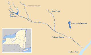
Patroon Creek is a stream in Albany County, New York, United States and is a tributary of the Hudson River which flows south to New York Harbor and the Atlantic Ocean. The creek's source is Rensselaer Lake in the western section of the city of Albany and flows along the northern border of said city with the town of Colonie to its mouth at the Hudson River. The creek received its name from the patroon of Rensselaerswyck.

Downtown Schenectady Neighborhood/Central business district in Capital District, New York, United States

Downtown Schenectady is the central business district for the city of Schenectady, New York. It originated in the 1820s with the moving of the commercial and industrial interests east from the original 17th and 18th century settlement, spurred on by the development of the Erie Canal. Home to the headquarters and major manufacturing plants of two large corporations, General Electric and American Locomotive Company, Downtown Schenectady catered to tens of thousands of workers in its heyday. Typical of the post-industrial Northeastern United States and Upstate New York in particular, Downtown Schenectady saw a decline in manufacturing and population starting in the 1970s. Recent construction and renovation has caused the downtown area to become an entertainment mecca for New York's Capital District anchored by Proctor's Theatre.

North Albany, Albany, New York Neighborhood in Albany County, New York, United States

North Albany is a neighborhood in the city of Albany, New York. North Albany was settled in the mid-17th century by the Patroon of Rensselaerswyck and his tenants and later became a hamlet in the town of Watervliet. Due to the Erie Canal being constructed in 1825, North Albany saw immense growth, with the Albany Lumber District and an influx of Irish immigrants lending the area the name of Limerick. Home to many historic warehouses and row houses, North Albany continues to be an important industrial neighborhood. Recent efforts have begun to gentrify the neighborhood by adapting heavy industry/warehouse use to artistic and entertainment venues, such as a German beer garden, an amusement park, live music venues, and arts and crafts marketplaces.

References

  1. 1 2 Frances Ingraham. "West Albany is a quiet neighborhood in Colonie". Albany Times Union. Retrieved 2010-02-07.
  2. George Howell and Jonathan Tenney (1886). Bi-centennial history of Albany: History of the county of Albany, NY from 1609-1886. W.W. Munsell and Company. p. 644. Retrieved 2010-02-05.
  3. George Howell and Jonathan Tenney (1886). Bi-centennial history of Albany: History of the county of Albany, NY from 1609-1886. W.W. Munsell and Company. p. 937. Retrieved 2010-02-05.
  4. Steve Sconfienza. "Steve's Railroad Pages; Local Information" . Retrieved 2010-02-07.
  5. Arthur James Weise (1884). The History of the City of Albany, New York. E.H. Bender. p. 479. Retrieved 2010-02-07.
  6. 1 2 Paul Grondahl (October 16, 2006). "Railroad's drive drove era of prosperity". Albany Times Union. Retrieved 2010-02-07.
  7. 1 2 Tim O'Brien (September 7, 2003). "Albany's Engine 999 Flew into History". Albany Times Union. Retrieved 2010-02-07.
  8. 1 2 Joann Crupi (July 4, 1999). "Diesels derail West Albany locomotive shops as the old engines disappear, so does an area industry". Albany Times Union. Retrieved 2010-02-07.
  9. Steve Sconfienza. "Steve's Railroad Pages; Selkirk Super Facts" . Retrieved 2010-02-07.
  10. Engineering World. International Trade Press. 1922. p. 356. Retrieved 2010-02-07.
  11. "John Morrell brands: Tobin's First Prize". John Morrell and Company. Retrieved 2010-02-07.
  12. Dennis Yusko (September 12, 1999). "Ex-Tobin hands share tales of the old days". Albany Times Union. Retrieved 2010-02-07.
  13. Jordan Carleo-Evangelist (July 28, 2006). "West Albany clings to past". Albany Times Union. Retrieved 2010-02-07.
  14. 1 2 Chris Churchill (December 24, 2009). "And First Prize Goes To..." Albany Times Union. Retrieved 2010-02-07.
  15. 1 2 Carol Demare (February 2, 2009). "New Life for Tobin Site". Albany Times Union. Retrieved 2010-02-07.