
The River Tees, in England, rises on the eastern slope of Cross Fell in the North Pennines and flows eastwards for 85 miles (137 km) to reach the North Sea in the North East of England. The modern-day history of the river has been tied with the industries on Teesside in its lower reaches, where it has provided the means of import and export of goods to and from the North East England. The need for water further downstream also meant that reservoirs were built in the extreme upper reaches, such as Cow Green.

County Durham, officially simply Durham (/ˈdʌrəm/), is a ceremonial county in North East England. The county borders Northumberland and Tyne and Wear to the north, the North Sea to the east, North Yorkshire to the south, and Cumbria to the west. The largest settlement is Darlington.

Newton Aycliffe is a town in County Durham, England. Founded in 1947 under the New Towns Act of 1946, the town is 5 miles (8.0 km) to the north of Darlington and 10 miles (16 km) to the south of Durham. It is the oldest new town in the north of England. Together with the bordering Aycliffe Village and the north part of School Aycliffe, it forms the civil parish of Great Aycliffe. The population of the town at the time of the 2021 census was 26,415.
Aislaby is a small village and civil parish on the north bank of the River Tees within the borough of Stockton-on-Tees and the ceremonial county of County Durham, England. It is located to the west of Eaglescliffe and Yarm. The name, first attested as Asulue(s)bi in 1086, is of Viking origin and means "Aslak's farm." Aislaby was listed in the Domesday Book of 1086.

Barmpton is a small village and civil parish in the borough of Darlington and the ceremonial county of County Durham, England. The population taken at the 2011 Census was less than 100. Details are maintained in the parish of Great Burdon. It is situated a short distance to the north-east of Darlington, on the River Skerne, a tributary of the Tees.

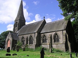
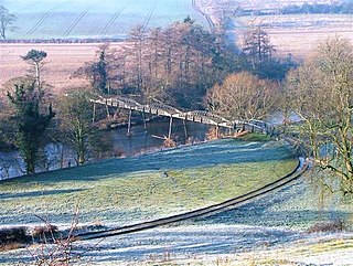
Piercebridge is a village and civil parish in the borough of Darlington and the ceremonial county of Durham, England. It is situated a few miles west of the town of Darlington. It is on the site of a Roman fort of AD 260–270, which was built at the point where Dere Street crossed the River Tees. Part of the fort is under the village green. The village is sited where the York-Newstead Roman road known as Dere Street crosses the River Tees.

Merrybent is a linear village in the civil parish of Low Coniscliffe and Merrybent in County Durham, in England. It is situated on the A67 road to the west of Darlington, a short distance to the north of the River Tees and the Teesdale Way. At the beginning of the 20th century there were hardly any buildings here, and its main feature at that time was Merrybent Nurseries with its many glasshouses. The nursery was cut through by the A1 road in the 1960s; at this point it runs on the trackbed of the old Merrybent railway. The village is now a settlement of modern housing.

Sockburn is a village and former civil parish, now in the parish of Neasham, in the Darlington district, in the ceremonial county of Durham, England. It is situated at the apex of a meander of the River Tees, to the south of Darlington, known locally as the Sockburn Peninsula. Today, all that remains of the village is an early nineteenth-century mansion, a ruined church and a farmhouse built in the late eighteenth century.

Winston is a village and civil parish in County Durham, England. It is situated approximately 6 miles (9.7 km) east of Barnard Castle, on a crossroads between the A67 and B6274 roads. According to the 2011 UK Census the population was 431, the parish includes the hamlets of Little Newsham and South Cleatlam.

Low Dinsdale is a village and former civil parish, now in the parish of Neasham, in the borough of Darlington and the ceremonial county of Durham, England. It is situated a few miles to the south-east of Darlington. On 1 April 2016 the parish was abolished and merged with Neasham and Middleton St. George.
Great Stainton is a village in the borough of Darlington and ceremonial county of County Durham, England. It is situated to the north of Darlington, and to the west of Stockton-on-Tees. Elstob is a hamlet, just north of Great Stainton, which is part of the Parish of Great Stainton. The population as taken at the Census 2011 was less than 100. Details are now maintained in the parish of Little Stainton.

Haughton-le-Skerne is a village in the borough of Darlington in the ceremonial county of Durham, England. It is situated in the north east of Darlington. The village lies to the west of the River Skerne. At the centre of the village green, is the main road towards Darlington town centre going across the river, south of the church. There used to be a linen mill on the riverbank on the east side of the village. Part of the mill leat can still be seen today.

The Borough of Darlington is a unitary authority area with borough status in County Durham, England. Since 1997 Darlington Borough Council has been a unitary authority; it is independent from Durham County Council. It is named after its largest settlement, the town of Darlington, where the council is based. The borough also includes a rural area surrounding the town which contains several villages. The population of the borough at the 2021 census was 107,800, of which over 86% (93,015) lived in the built-up area of Darlington itself.
Whinney Hill is a village within the borough of Stockton-on-Tees and the ceremonial county of County Durham, England. Whinney Hill lies 2 miles (3.2 km) west of Stockton-on-Tees.

Dalton-on-Tees is a village and civil parish in North Yorkshire, England, near the boundary with County Durham. According to the 2001 Census there were 318 people living in the parish in 120 houses. The population had decreased to 303 by the time of the 2011 Census.

Cliffe is a small village and civil parish in Richmondshire district of North Yorkshire, England. A stream called the Glen runs through the village to the Tees. It is in the Teesdale and Yorkshire Dales national park. It is about 6 miles (10 km) west of Darlington, 10 miles (16 km) north of Richmond and near Piercebridge.

Eryholme is a village and civil parish in North Yorkshire, England. As the population remained less than 100 in the 2011 census, information is included with that of Dalton-on-Tees.
Girsby is a village and civil parish in the former Hambleton District of North Yorkshire, England. The village lies on high ground on the eastern bank of the River Tees. The population of the parish was estimated at 40 in 2015. The population as of the 2011 census remained less than 100. Details are included in the civil parish of Over Dinsdale.
Neasham Priory was a priory founded for a community of Benedictine nuns before 1157. Located on the River Tees near Sockburn, County Durham, it was the only such institution in the county to be independent of Durham Cathedral Priory. It was apparently never wealthy or notable.

County Durham is a unitary authority area in the ceremonial county of County Durham, England. It is governed by Durham County Council. The district has an area of 2,226 square kilometres (859 sq mi), and contains 135 civil parishes. It forms part of the larger ceremonial county of Durham, together with boroughs of Darlington, Hartlepool, and the part of Stockton-on-Tees north of the River Tees.

