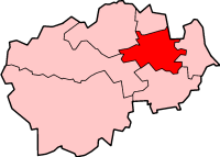
Durham most commonly refers to:

The City of Durham was, from 1974 to 2009, a non-metropolitan district of County Durham in North East England, with the status of borough and city.

Staindrop is a village, civil parish, former ecclesiastical parish and manor situated east of Barnard Castle in County Durham, England. The population at the 2011 census was 1,310.

Bearpark is a village and civil parish in County Durham in England. It is situated two and a half miles west of Durham, and a short distance to the north of Ushaw Moor. The name may be a corruption of the French term Beau Repaire – meaning "beautiful retreat". Half a mile to the north of the present village lies the ruins of Beaurepaire Priory, built in 1258 by the Prior of Durham, Bertram de Middleton, as a retirement residence. The building was extended in the subsequent three centuries, becoming a retreat for the Durham monks in a similar way to the nearby Finchale Priory. The manor was largely destroyed by the Scots in 1640 and 1644 during the British Civil War. In 1872, Theodore Fry was involved in founding the Bearpark Coal and Coke Company, which established a coal mine in Bearpark until 1984, when the mine was closed.

Belmont is a suburb of the city of Durham and civil parish in the County Durham district, in the county of Durham, England. It was formerly a separate village. It was initially a coal mining village and is situated to the north-east of the city centre, just east of the A1(M) motorway. The flats at Minster Court were built on land formerly belonging to Ravensflatt Farm. According to the 2001 census it had a population of 8,939, decreasing to 8,881 at the 2011 Census.

Brafferton is a village and civil parish in County Durham, England. It is administered as part of the borough of Darlington. The population of Brafferton Parish taken at the 2011 census was 154. It is situated between Darlington and Newton Aycliffe, a short distance from Coatham Mundeville.

Egglescliffe is a village and civil parish which for ceremonial purposes is in County Durham, England. Administratively it is located in the borough of Stockton-on-Tees. It was formerly part of the non-metropolitan county of Cleveland.

Sherburn or Sherburn Village it is part of the unitary authority of County Durham lying 3.5 miles east of Durham in the north east of England.

Langton is a village and civil parish in County Durham, in England. It is situated to the west of Darlington, near Headlam and Ingleton. The population of the civil Parish taken at the 2011 Census was less than 100. Information is contained in the parish of Ingleton, County Durham.

Stanhope is a small market town in County Durham, England, situated on the River Wear between Eastgate and Frosterley on the north-east side of Weardale. The A689 road meets the B6278 road from Barnard Castle to Shotley Bridge in the town.

Westwick is a hamlet in Cambridgeshire, in England. It is situated to the north-west of Cambridge, and is part of the parish of Oakington and Westwick. Earthworks suggest that it is a shrunken medieval village.

Westwick is a village and civil parish in the English county of Norfolk, situated to the south of North Walsham. It covers an area of 4.88 km2 (1.88 sq mi) and had a population of 53 in 29 households at the 2001 census. The population remained less than 100 at the 2011 Census and was included in the civil parish of Swanton Abbott. For the purposes of local government, it falls within the district of North Norfolk.

Westwick Row is a place in Hertfordshire, in England. It is situated on the edge of Hemel Hempstead.

Oakington is a small rural Anglo-Saxon village 7 miles north-west of Cambridge in Cambridgeshire in England, and belongs to the administrative district of South Cambridgeshire. Since 1985 the village has formed part of the parish of Oakington and Westwick.

Edward Jack Peter Westwick, is an English actor and musician, best known for his role as Chuck Bass on The CW's teen television drama series Gossip Girl alongside co-stars Blake Lively and Leighton Meester. He made his feature film debut in Children of Men (2006) and has since appeared in the films Breaking and Entering (2006), Son of Rambow (2007), S. Darko (2009), Chalet Girl (2011), J. Edgar (2011), Romeo and Juliet (2013), Bone in the Throat (2015), Freaks of Nature (2015), and Billionaire Ransom (2016). He currently plays Vincent Swan in the BBC Two television comedy series White Gold (2017).

Westwick is a civil parish in Harrogate district in North Yorkshire, England. It lies 3 miles (5 km) west of Boroughbridge, on the south bank of the River Ure. It is a small parish of only 422 acres (171 ha), and consists of a few scattered houses. In 2012 the population of the parish was estimated at 10. As the population was less than 100 at the 2011 Census details are included by ONS in the civil parish of Skelton-on-Ure.

Claxton is a civil parish in County Durham, England. It had a population of 25 at the 2001 Census.


