Walworth, County Durham

Last updated

Walworth
Cuckoo House. - geograph.org.uk - 162001.jpg
Cuckoo House, an outlying part of Walworth
Durham UK location map.svg
Red pog.svg
Walworth
Location within County Durham
Population240 (including Archdeacon Newton and Houghton-le-Side. 2011)
OS grid reference NZ234188
Unitary authority
Ceremonial county
Region
Country England
Sovereign state United Kingdom
Post town Darlington
Postcode district DL2
Dialling code 01325
Police Durham
Fire County Durham and Darlington
Ambulance North East
UK Parliament
List of places
UK
England
County Durham
54°33′54″N1°38′20″W / 54.565°N 1.639°W / 54.565; -1.639 Coordinates: 54°33′54″N1°38′20″W / 54.565°N 1.639°W / 54.565; -1.639

Walworth is a central small village with outlying farmsteads, which together constitute a scattered village in the borough of Darlington and the ceremonial county of County Durham, England. It is a civil parish which does not have a church. The population of this civil parish at the 2011 Census was 240. [1] It is situated 2.5 miles (4.0 km) to the north-west of Darlington. The nucleus of the central village is the 16th-century Walworth Castle, which is now a hotel. On the north side of the village, around North Farm, are earthworks signifying a lost settlement, grouped around a barn which was once a chapel.

Contents

Central village location and structure

Walworth Castle, the nucleus of the central village Walworth Castle Hotel. - geograph.org.uk - 150434.jpg
Walworth Castle, the nucleus of the central village

Walworth and Walworth Gate are said to be on the line of the Roman road, Dere Street. [2] Walworth is located at the T-junction where Newton Lane meets Walworth Road and the disused Quarry Hole, 2.5 miles (4.0 km) north-west of Darlington and 0.31 miles (0.50 km) east of Denton. The village is triangular in plan, with Walworth Castle and Walworth Park at its centre. North Farm and the lost settlement of Walworth are at the north corner; Castle farm and Tomtit Wood are at the south-west corner, and Walworth Grange and a few houses are at the south-east corner. [3] The village used to be part of Heighington parish, but the settlement now has its own civil parish. [4] Although there is evidence of a former chapel in the lost settlement, [5] the village does not have a church. The population here is very low; in 2001 there were only 167 people on the electoral roll of Denton, Walworth and Houghton-le-Side who were eligible to vote at Walworth Castle polling station. [6]

Walworth Castle

The central feature of the village, and its landmark for miles, is its very large, 16th-century mansion house built in the style of a medieval castle, which is now a hotel. It is a Grade 1 listed building, [7] probably built by Thomas Holt in around 1600 for Thomas Jennison. [8] It may be that earthworks and cropmarks in Walworth Park in the castle grounds signify a lost settlement associated with the one at North Farm. [9] [10] [11]

History

Swan House farm Swan House Farmhouse and Cottage - geograph.org.uk - 1751237.jpg
Swan House farm

The name "Walworth" means Welsh settlement, [12] and it used to be known as Waleberge after the Saxons claimed it. It is thought that Walworth was planned as a village with the previous castle around 1150 by the Hansard family as part of their 1,100 acres (4.5 km2) estate. There is a legend that Malcolm III of Scotland destroyed the village on his way along the River Tees. Following the Black Death there was a change of ownership of the manor to the Neville family by 1367, but in 1391 Robert Hansard claimed it back. [13] The Ayscough family acquired the manor by marriage in 1539, then Thomas Jenison bought it in 1579 when the Ayscough family had no heirs. [14] At the death of Elizabeth Jenison in 1605, the farm stock inventory included 50 oxen besides cattle, sheep, pigs, horses and corn. In 1759 the estate left the hands of the Jenisons due to the death and debts of Ralph Jenison. [15] From 1759 to 1831 the estate belonged to Matthew Stephenson, and then it was sold to the Aylmer family who owned it until 1931. Their descendants Neville and Charles Eade owned it from 1931 to 1950, and then it was sold in 1950 to Durham County Council. The estate was broken up and sold into private ownership in 1981, and present ownership of the village is unknown. [16]

Historical sites

Barns at Castle Farm Castle Farm - geograph.org.uk - 90616.jpg
Barns at Castle Farm

There is no evidence of prehistoric or Roman activity in this area, but the area has not been fully excavated. [17] In May 2004 a barbed and tanged arrowhead was found at Quarry Cottage, where Newton Lane meets Walworth Road. Because this site was a quarry, the arrowhead may have been moved from its original site before it was found. [18] In 1991 some archaeological evaluation trenches were dug next to the castle itself, in advance of hotel development; however, no traces were found of archaeological material. [19] About 0.6 miles (0.97 km) to the east of Walworth, in a field just east of Back Lane, is the site of a former post-medieval brick and tile works. [20] There was another brick and tile works 0.3 miles (0.48 km) north-east of North Farm on Silver Hill, just west of Back Lane. [21]

Coldsides Farm, on the edge of the parish Coldsides. - geograph.org.uk - 161986.jpg
Coldsides Farm, on the edge of the parish

North of the village, just south of New Moor Farm and just to the west of Walworth Road, is the site of a post-medieval lime kiln. [22] The disused limestone quarry called Quarry Hole, where Newton Lane meets Walworth Road, is post-medieval also, [23] [24] and it once had an associated lime kiln. [25] 0.9 miles (1.4 km) north-west of Walworth, between Newton Lane and the A68 road, is the post-medieval Paradise Cottage, once known as Hood's Cottage, with an associated well. [26] There is an overgrown well on the west side of Walworth Road and level with the castle gate, at the north end of Tomtit Wood. It is made of stone with a trough to collect water. [27] Estimated to be about 0.31 miles (0.50 km) west of Walworth village, and halfway between Walworth and Denton, is the site of a medieval mill. The evidence for this is from field names on tithe maps and manuscripts. [28] There is a late 18th- or early 19th-century listed ice house to the east of Quarry End, at Quarry Hole. It is built into a bank, and has a partially-collapsed barrel-vaulted passage connected to a deep, egg-shaped cavity intended for the ice. It is built of coursed rubble and the inside is brick-lined. [29] On the east side of Walworth Grange are a Grade II listed late 18th- or early 19th-century threshing barn and gin gang. They are built of limestone with pantiled roofs, and the gin gang is semi-octagonal with square piers and later infilled walls. [30]

Barns at Castle farm Barn at Castle Farm - geograph.org.uk - 75419.jpg
Barns at Castle farm

Parkside Farmhouse at Castle Farm is a listed building, built in the early 19th century with squared limestone walls and purple slate roof. [31] On its south side is a large 19th-century, two-storey, pantiled, square-plan dovecote which is listed separately along with some sheds, including a possible bee bole. [32] The 19th-century limestone gate piers with rounded tops and 5 feet (1.5 m) to 6.5 feet (2.0 m) high limestone garden wall of Parkside Farmhouse are listed also. The wall has flat coping and is L-shaped, surrounding two sides of the farmhouse. The wall may have contained flues to heat soft fruit. [33] Also on the south side of the farm house is another set of early 19th-century listed sheds and barn with assorted roofing: asbestos, pantiles and stone flags. The single-storey sheds contain blocked arches. [34] There is also a listed 19th-century haybarn and former potato shed on the south side of the farmhouse. The haybarn is built of squared limestone and sandstone with brick arches. [35]

Site of lost settlement at North Farm North Farm and the Medieval Village of Walworth - geograph.org.uk - 75448.jpg
Site of lost settlement at North Farm

Lost settlement

At the north end of the village, the fields on the east and west sides of the North Farm buildings contain earthworks signifying a lost settlement. There are some isolated ruins and two rows of building foundations, and ditches and banks which form enclosures. The chapel was built in 1180 of squared and coursed rubble, and has since been incorporated into the northernmost farm building with blocked original openings and indications of the original door and window still visible, although it has 19th-century doorways and a pantiled roof. Inside there is evidence of a pointed arch containing a piscina with trefoil head, and a large aumbry at the east end of the south wall. The opening at the east end on the north wall is also possibly an aumbry. [5] [17] [36] There is evidence of ridge and furrow fields remaining in Walworth Park which may be associated with this settlement. [9] In 2007 there was a watching brief when an electricity supply trench was dug in the middle of the lost settlement site, just north-east of the farm buildings, but no archaeological evidence was found. [37]

Related Research Articles

Abbots Bromley Human settlement in England

Abbots Bromley is a village and civil parish within the English county of Staffordshire, England. A notably affluent part of the county, Abbots Bromley was rated the best place to live in the Midlands by the Sunday Times in 2013 and again in 2016. The village is a regular entrant and often winner of the Staffordshire Best Kept Village Competition which takes place across the county each year. Originally organised by the Community Council of Staffordshire there is a best-kept village award for a large and small village in each of the county's Districts and Boroughs. Whilst down the years the East Staffordshire district prize has been awarded to Abbots Bromley on a number of occasions the overall county title continues to elude. In August 2017 the village won the double honour of winning both the best kept village and community council trophy award, a double not achieved for many years. This double was repeated again in 2018. In 2019 the competition was taken on by The Community Foundation for Staffordshire and Abbots Bromley won for the third consecutive year. Through the competition Abbots Bromley maintains a healthy rivalry with nearby Yoxall, also a regular winner in the East Staffordshire section.

Archdeacon Newton Human settlement in England

Archdeacon Newton is a hamlet and rural parish of several farms in the borough of Darlington and the ceremonial county of County Durham, in England. The population taken at the 2011 Census was less than 100. Details are maintained in the parish of Walworth. It is associated with an abandoned village site under pasture and farm buildings, and situated a short distance to the north-west of Darlington. The lost settlement was in existence by the early 15th century, and remained inhabited at least until the 1890s. There was a moated manor house at the southern end, part of which remains as the Old Hall, now a barn. At the north end of the site was the chapel, and in the middle were tofts and enclosures, with a ridge and furrow field and a trackway leading to the south-east. The site of the abandoned village is now a scheduled monument and the Old Hall is a listed building.

High Coniscliffe Human settlement in England

High Coniscliffe is a parish and village in the borough of Darlington and ceremonial county of County Durham, England. The parish includes Carlbury and Low Coniscliffe. It is part of Heighington and Coniscliffe ward, and is situated approximately 4 miles (6.4 km) west of Darlington. At the 2011 Census the population of this civil parish was 242.

Merrybent Human settlement in England

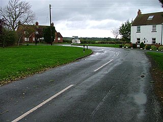
Merrybent is a linear village in the civil parish of Low Coniscliffe and Merrybent in County Durham, in England. It is situated on the A67 road to the west of Darlington, a short distance to the north of the River Tees and the Teesdale Way. At the beginning of the 20th century there were hardly any buildings here, and its main feature at that time was Merrybent Nurseries with its many glasshouses. The nursery was cut through by the A1 road in the 1960s; at this point it runs on the trackbed of the old Merrybent railway. The village is now a settlement of modern housing.

Low Coniscliffe Human settlement in England

Low Coniscliffe is a village in the civil parish of Low Coniscliffe and Merrybent, in County Durham, England. The population of the civil parish taken at the 2011 Census was 716. It is situated 3 miles (4.8 km) west of Darlington. Its present built-up area is confined in practice between the A1, the A67 and the Tees, but its old boundaries probably extend much further. Its most obvious landmark on the A67 is the Baydale Beck Inn. The village contains a couple of listed buildings and the probable site of a medieval manor house. There was once a gallows in the village. A rare fungus Rhodotus palmatus was found nearby.

Low Walworth Human settlement in England

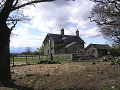
Low Walworth is a hamlet in County Durham, England, 1.5 miles (2.4 km) to the north−west of the edge of Darlington. It consists of Low Walworth Hall, Low Walworth Farm and their respective cottages, flats and outbuildings. Several of these buildings are listed, and date from the 17th to the 19th century. Attached to one of the late-18th-century farm buildings is a gin gang, or building from which a horse powered a threshing machine by walking in a circle. The hall has accommodated at least one High Sheriff of Durham.

Walworth Gate Human settlement in England

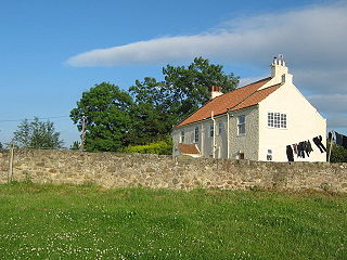
Walworth Gate is a hamlet and crossroads village in the borough of Darlington, in the civil parish of Walworth and the ceremonial county of County Durham, England. It is situated 2 miles (3.2 km) north−west of the edge of Darlington and 0.6 miles (0.97 km) north of Walworth. The settlement is locally notable for New Moor Farm, which is known to Darlington people as a producer of ice cream. The Saxon origin of the name, "Walworth Gate", refers to Welsh−speaking Britons who once lived there.

Howardian Hills

The Howardian Hills are an Area of Outstanding Natural Beauty located between the Yorkshire Wolds, the North York Moors National Park and the Vale of York, they take their name from the Howard family who still own local lands.

Blickling Human settlement in England

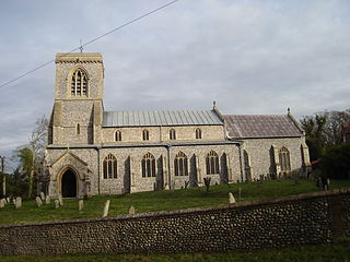
Blickling is a village and civil parish in the Broadland district of Norfolk, England, about 1.5 miles (2.4 km) north-west of Aylsham. According to the 2001 census it had a population of 136 and covers 862 hectares, falling to 113 at the 2011 Census. Since the 17th century the village has been concentrated in two areas, around the church and also at the park gates of Blickling Hall. Most of the village is contained in the Blickling Estate, which has been owned by the National Trust since 1940.

Luddington, Lincolnshire Village, part of the civil parish of Luddington with Haldenby, on the Isle of Axholme in North Lincolnshire, England

Luddington is a village, part of the civil parish of Luddington with Haldenby, on the Isle of Axholme in North Lincolnshire, England. The population of the civil parish at the 2011 census was 419. It is 6 miles (10 km) north-west from Scunthorpe, 6 miles south-east from Goole and 18 miles (29 km) north-east from Doncaster.

Peckforton Human settlement in England

Peckforton is a scattered settlement and civil parish in the unitary authority of Cheshire East and the ceremonial county of Cheshire, England. The settlement is located 6.5 miles (10.5 km) to the north east of Malpas and 7.5 miles (12.1 km) to the west of Nantwich. The civil parish covers 1,754 acres (710 ha), with an estimated total population of 150 in 2006. The area is predominantly agricultural. Nearby villages include Bulkeley to the south, Beeston to the north, Higher Burwardsley to the west, Spurstow to the east and Bunbury to the north east.

Great Hinton Human settlement in England

Great Hinton is a small village and civil parish about 3 miles (4.8 km) south of Melksham and 3.5 miles (5.6 km) north-east of Trowbridge in Wiltshire, England. The parish includes the hamlets of Bleet and Cold Harbour.

Walworth Castle

Walworth Castle is an 11th Century castle, situated at Walworth, near Darlington, County Durham, England. It is a Grade 1 listed building. It was completed around 1600, probably by Thomas Holt for Thomas Jenison. It stands on the site of a former manor house or castle built in the 12th century by the Hansard family. The estate passed through the hands of the Ayscoughs and Aylmers besides the Hansards and Jenisons, and became a prisoner-of-war camp during World War II and then a girls' boarding school after the war. It has been a hotel since 1981.

Loversall Village and civil parish in South Yorkshire, England

Loversall is a village and civil parish in the Metropolitan Borough of Doncaster in South Yorkshire, England. It has a population of 128, increasing to 156 at the 2011 Census.

Ulnaby Human settlement in England

Ulnaby is an abandoned village and scheduled ancient monument in the grounds of Ulnaby Hall Farm, near High Coniscliffe, County Durham, England. The toft village was occupied from the late-13th to the 16th century and temporary buildings were erected in the 19th century. Ulnaby Hall farm appears to have been built in the late-16th century, supplanting a high status medieval manorial enclosure associated with the original village. It is thought that the village shrank because of the change from labour-intensive arable farming to pasture, before being abandoned and the site was subsumed into the farm as pasture.

Gin gang

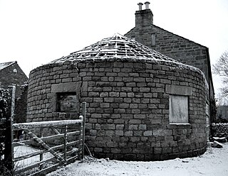
A gin gang, wheelhouse, roundhouse or horse-engine house, is a structure built to enclose a horse engine, usually circular but sometimes square or octagonal, attached to a threshing barn. Most were built in England in the late 18th and early 19th centuries. The threshing barn held a small threshing machine which was connected to the gin gang via wooden gears, drive shafts and drive belt, and was powered by a horse which walked round and round inside the gin gang.

Scheduled monuments in Mendip

Mendip is a local government district of Somerset in England. The Mendip district covers a largely rural area of 285 square miles (738 km2) ranging from the Mendip Hills through on to the Somerset Levels. It has a population of approximately 110,000. The administrative centre of the district is Shepton Mallet but the largest town is Frome.

Dormington Human settlement in England

Dormington is a village and civil parish in Herefordshire, in the West Midlands of England. Dormington village is at the north of its parish, 5 miles (8 km) east from the centre of the city and county town of Hereford, and 8 miles (13 km) west-northwest from the town of Ledbury. The parish is a significant traditional centre for hop growing.

Ballidon Dale Valley in the Derbyshire Peak District

Ballidon Dale is a steep-sided, dry carboniferous limestone valley near Parwich in the Derbyshire Peak District of England. The ancient hamlet of Ballidon lies at the southern foot of the dale. Ballidon Quarry and Hoe Grange limestone quarries now dominate the west side of the dale.

References

  1. "Civil Parish population 2011" . Retrieved 2 February 2016.
  2. "Keys to the past". Walworth, Walworth Gate; Roman road. (Walworth). DBC. 2010. Retrieved 12 April 2010.
  3. "Streetmap". Location 423500,518500. 2010. Retrieved 23 April 2010.
  4. "Keys to the past". Local History: Heighington (County Durham). DBC. 2010. Retrieved 13 April 2010.
  5. 1 2 "Keys to the past". Walworth; remains of C12 chapel. (Walworth). DBC. 2010. Retrieved 12 April 2010.
  6. "The Northern Echo". All quiet in hotel that had to cancel offer. 8 June 2001. Retrieved 14 April 2010.
  7. Historic England. "Details from listed building database (1121175)". National Heritage List for England . Retrieved 14 April 2010.
  8. "Keys to the past". Walworth castle; Listed building (Walworth). DBC. 2010. Archived from the original on 16 June 2011. Retrieved 12 April 2010.
  9. 1 2 "Keys to the past". Walworth Park; Medieval parkland (Walworth). DBC. 2010. Archived from the original on 16 June 2011. Retrieved 12 April 2010.
  10. "Keys to the past". Walworth Park; Possible enclosure (Walworth). DBC. 2010. Archived from the original on 16 June 2011. Retrieved 12 April 2010.
  11. "Keys to the past". Walworth; earthworks. (Walworth). DBC. 2010. Archived from the original on 16 June 2011. Retrieved 12 April 2010.
  12. Simpson, David (2009). "Roots of the region". Place-Name Meanings T to Y: Walworth (County Durham). Retrieved 15 April 2010.
  13. "Best Western: The Castle". The history of Walworth Castle 1050–1508. Best Western. 2010. Retrieved 13 April 2010.
  14. "Best Western: The Castle". The history of Walworth Castle 1508–1605. Best Western. 2010. Retrieved 13 April 2010.
  15. "Best Western: The Castle". The history of Walworth Castle 1605–1759. Best Western. 2010. Retrieved 13 April 2010.
  16. "Best Western: The Castle". The history of Walworth Castle 1759–present. Best Western. 2010. Retrieved 13 April 2010.
  17. 1 2 "Keys to the past". Walworth (County Durham). DCC. 2010. Archived from the original on 16 June 2011. Retrieved 12 April 2010.
  18. "Keys to the past". Walworth, Quarry Cottage; Find Spot (Walworth). DBC. 2010. Retrieved 12 April 2010.
  19. "Keys to the past". Walworth Castle Hotel; Archaeological Evaluation (Walworth). DBC. 2010. Archived from the original on 16 June 2011. Retrieved 12 April 2010.
  20. "Keys to the past". Walworth location A; Brick and Tile Works (Walworth). DBC. 2010. Retrieved 12 April 2010.
  21. "Keys to the past". Walworth location B; Brick and tile works (Walworth). DBC. 2010. Retrieved 12 April 2010.
  22. "Keys to the past". Walworth location 3; Limekiln (Walworth). DBC. 2010. Retrieved 12 April 2010.
  23. "Keys to the past". Walworth location 1; Limestone quarry (Walworth). DBC. 2010. Retrieved 12 April 2010.
  24. "Keys to the past". Walworth location 2; Limestone quarry (Walworth). DBC. 2010. Retrieved 12 April 2010.
  25. "Keys to the past". Walworth location 4; Limekiln (Walworth). DBC. 2010. Retrieved 12 April 2010.
  26. "Keys to the past". Walworth, Paradise; Cottage (Walworth). DBC. 2010. Retrieved 12 April 2010.
  27. "Keys to the past". Walworth; Well (Walworth). DBC. 2010. Retrieved 12 April 2010.
  28. "Keys to the past". Walworth Mill; Possible medieval mill (Walworth). DBC. 2010. Retrieved 12 April 2010.
  29. "Keys to the past". Ice house to east of quarry end; Listed building (Walworth). DBC. 2010. Retrieved 12 April 2010.
  30. "Keys to the past". Threshing barn and gin gang east of walworth grange; Listed building (Walworth). DBC. 2010. Retrieved 12 April 2010.
  31. "Keys to the past". Parkside farmhouse; Listed building (Walworth). DBC. 2010. Retrieved 12 April 2010.
  32. "Keys to the past". Dovecote and single storey range to south of parks; Listed building (Walworth). DBC. 2010. Retrieved 13 April 2010.
  33. "Keys to the past". Garden wall and gate piers in front of parkside fa; Listed building (Walworth). DBC. 2010. Retrieved 13 April 2010.
  34. "Keys to the past". Barn and flanking shelter sheds to south of parksi; Listed building (Walworth). DBC. 2010. Retrieved 13 April 2010.
  35. "Keys to the past". Haybarn and attached shed south of parkside farmho; Listed building (Walworth). DBC. 2010. Retrieved 13 April 2010.
  36. "Keys to the past". Barn to north of north farm farmhouse; Listed building (Walworth). DBC. 2010. Retrieved 12 April 2010.
  37. "Keys to the past". Darlington, Walworth; Watching brief (Walworth). DBC. 2010. Retrieved 12 April 2010.