Archdeacon Newton

Last updated

Archdeacon Newton
Archdeacon Newton 002.jpg
Garthorne Farm at Archdeacon Newton
Durham UK location map.svg
Red pog.svg
Archdeacon Newton
Location within County Durham
OS grid reference NZ255175
Unitary authority
Ceremonial county
Region
Country England
Sovereign state United Kingdom
Post town DARLINGTON
Postcode district DL2
Dialling code 01325
Police Durham
Fire County Durham and Darlington
Ambulance North East
UK Parliament
List of places
UK
England
County Durham
54°33′08″N1°36′26″W / 54.55211°N 1.60727°W / 54.55211; -1.60727 Coordinates: 54°33′08″N1°36′26″W / 54.55211°N 1.60727°W / 54.55211; -1.60727

Archdeacon Newton is a hamlet and rural parish of several farms in the borough of Darlington and the ceremonial county of County Durham, in England. The population taken at the 2011 Census was less than 100. Details are maintained in the parish of Walworth. It is associated with an abandoned village site under pasture and farm buildings, [1] and situated a short distance to the north-west of Darlington. The lost settlement was in existence by the early 15th century, and remained inhabited at least until the 1890s. There was a moated manor house at the southern end, part of which remains as the Old Hall, now a barn. At the north end of the site was the chapel, and in the middle were tofts and enclosures, with a ridge and furrow field and a trackway leading to the south-east. The site of the abandoned village is now a scheduled monument and the Old Hall is a listed building.

Contents

Geographical and political

Townend Farm Archdeacon Newton. - geograph.org.uk - 140962.jpg
Townend Farm

The underlying composition here is of glacial clay with pockets of gravel, sand, peat and alluvium, and patches of dolomite and carboniferous limestone. [2] This is a small hamlet incorporating Hall Farm, Garthorne Farm and Townend Farm on an approach road south of Newton Lane. It is the focus of the parish of Archdeacon Newton rural ward, and its councillor is Rosalind Tweddle. [3] It is situated on flat land 0.62 miles (1.00 km) to the north-west of the Branksome suburb of Darlington, and 0.31 miles (0.50 km) to the north-west of the A1 road. At Cockerton near the southern end of Newton Lane and 1.2 miles (1.9 km) to the south-east of the hamlet is its namesake, the Archdeacon pub; Michael Perry, Archdeacon of Durham, posed for the sign in 1980, although the sign has since been replaced. [4]

History

The hamlet apparently once contained a chapel; [5] it now a parish of 1,063.5 acres (4.304 km2), [6] although it was once part of Darlington parish. [7] The area enclosed by Townend Farm and Archdeacon Newton's approach road to the west, Newton Lane to the north, and Hall Farm to the south contains the site of a medieval abandoned village, with visible earthworks in pasture at the northern end and farm buildings at the southern end of the site: [8] this is a scheduled monument. The hamlet's name derives from the fact that in the Middle Ages the Archdeacon of Durham founded and built what is now the abandoned village. [7] An alternative theory says that the land was leased from the archdeacon. [4] Around 1800, Hilton "High Price" Middleton of Archdeacon Newton bred a great Durham Ox, and the now-defunct Newton Kyloe pub at Cockerton Green was named after it. [4] In 1894 the land was owned by the Church Commissioners and the population was 52; [9] down from its highest level of 72 in 1801, when pews were reserved for Archdeacon Newton people at St Cuthbert's in the centre of Darlington, and Methodist prayers were said in a farmhouse kitchen. This was before the nearer church of Holy Trinity, Darlington, was built in 1836. [10] The 1851 census shows residents with surnames of Brown and Geldart or Geldert. [9]

Archaeological sites and finds

The manor of this village survives at Hall Farm as a farm building with some medieval features, and an adjacent farm building was probably once an early 16th-century house. Apart from these buildings, the abandoned village is indicated by earthworks of a medieval moated site and enclosures. There are also indications of three fish ponds, of which one is still a duck pond, [1] and two contain rubbish; however it is now thought that there was originally a single fish pond. One of the supposed fish ponds is among the farm buildings and is overgrown. [8] Prehistoric and Roman remains have not yet been found here, as there have been no excavations as of April 2010. [7]

Abandoned settlement

The area to the east of the Archdeacon Newton approach road, and to the south of Newton Lane, is the location of the medieval abandoned village and scheduled monument. [5] The manor and house were at the southern end of a settlement which had three farms and a row of cottages, indicated in the existing pasture by house platforms. [5] It is now thought that the buildings were tenant tofts attached to the manor, and not a nucleated village. [8] Cobbled banks and ditches running east to west and situated towards the north end of the site identify the original enclosures of these tofts. [1] [8] The banks are 13 feet (4.0 m) wide and 2 feet (0.61 m) high, and the ditches are 10 feet (3.0 m) wide and 1 foot (0.30 m) deep. [8] There is an associated ridge and furrow field, and a 13 feet (4.0 m) wide trackway runs from halfway along the east side of the site, in a south-easterly direction, for 790 feet (240 m) as far as a modern fence. [8] An undated trench for electricity supply was dug at Hall Farm at the southern end of the hamlet's approach road, surveyed by an archaeological watching brief, but nothing of historical interest was found. [11]

Old Hall and moated site

Hall Farm with Old Hall to its right Archdeacon Newton 001.jpg
Hall Farm with Old Hall to its right

The Old Hall, [12] one of the farm buildings at the centre of Hall Farm, is a surviving medieval domestic building or manor house, probably dating from the 14th century and remodelled in the 16th and 17th century. It was burned and then re-roofed in the early 21st century, and no internal partitions survive. [13] This is a two-storey listed building which was converted to a barn in the 19th century, has a Welsh slate roof and seven internal bays. It is built of squared and rubble masonry with ashlar dressing. The structure includes medieval and Tudor carved stone, including mullions and fireplaces. [14] Buttresses, broken arches and fireplaces of the manor are still standing and are incorporated in the Old Hall. [1] It is 59 feet (18 m) by 30 feet (9.1 m), containing two Tudor fireplaces, with the remains of archways on the outside walls at each end. [8]

The moated manor house stood at the southern end of the abandoned village site, where there are now farm buildings. In the 16th and 17th centuries the manor had a hall with parlour and chamber over the hall, a new chamber, a little chamber, a "lofte beneath the doors", a buttery, a kitchen and a stable. Depressions in the ground at the southern end of the site indicate the position of the original moat. [5]

Chapel

It is thought that the chapel was on the 6.5 feet (2.0 m) high triangular platform at the north end of the site and on the south side of Newton Lane. [5] There is a ditch along the south side of this feature. [8] Evidence for the chapel exists in a licence given in 1414 to Robert Fisher, John Nicholson and John Deves to hold religious services in a chapel at Archdeacon Newton. [7]

Enclosure

Another enclosure has been identified by aerial photography 0.31 miles (0.50 km) north-west of the hamlet, and on the south side of Newton Lane. [15]

Related Research Articles

High Bradfield Village in South Yorkshire, England

High Bradfield is a rural village 6.5 miles (10 km) north-west of the centre of Sheffield in South Yorkshire, England and within the city's boundaries. The village lies just within the Peak District National Park, 1.3 miles (2 km) inside the park's north-eastern border, is at an altitude of 260 metres (850 feet) AOD and has extensive views across Bradfield Dale towards Derwent Edge and the Dark Peak.

Newton Aycliffe Human settlement in England

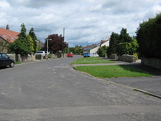
Newton Aycliffe is a town in County Durham, England. Founded in 1947 under the New Towns Act of 1946, the town sits about five miles to the north of Darlington and ten miles to the south of the Durham. It is the oldest new town in the north of England, and together with the bordering Aycliffe Village and the north part of School Aycliffe, forms the civil parish of Great Aycliffe. The population of the town at the time of the 2011 census was 26,633.

Carlbury Village in County Durham, England

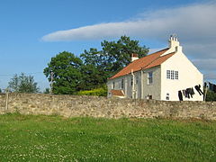
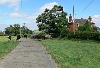
Carlbury is a hamlet in the civil parish of High Coniscliffe in County Durham, in England. It is situated a few miles to the west of Darlington, on the north bank of the River Tees between Piercebridge to the west, and High Coniscliffe to the east. High and Low Carlbury once constituted a slightly larger settlement, but most of the hamlet at Low Carlbury became derelict and was demolished by the late 1940s. A few buildings remain.

High Coniscliffe Human settlement in England

High Coniscliffe is a parish and village in the borough of Darlington and ceremonial county of County Durham, England. The parish includes Carlbury and Low Coniscliffe. It is part of Heighington and Coniscliffe ward, and is situated approximately 4 miles (6.4 km) west of Darlington. At the 2011 Census the population of this civil parish was 242.

Merrybent Human settlement in England

Merrybent is a linear village in the civil parish of Low Coniscliffe and Merrybent in County Durham, in England. It is situated on the A67 road to the west of Darlington, a short distance to the north of the River Tees and the Teesdale Way. At the beginning of the 20th century there were hardly any buildings here, and its main feature at that time was Merrybent Nurseries with its many glasshouses. The nursery was cut through by the A1 road in the 1960s; at this point it runs on the trackbed of the old Merrybent railway. The village is now a settlement of modern housing.

Low Coniscliffe Human settlement in England

Low Coniscliffe is a village in the civil parish of Low Coniscliffe and Merrybent, in County Durham, England. The population of the civil parish taken at the 2011 Census was 716. It is situated 3 miles (4.8 km) west of Darlington. Its present built-up area is confined in practice between the A1, the A67 and the Tees, but its old boundaries probably extend much further. Its most obvious landmark on the A67 is the Baydale Beck Inn. The village contains a couple of listed buildings and the probable site of a medieval manor house. There was once a gallows in the village. A rare fungus Rhodotus palmatus was found nearby.

Walworth, County Durham Human settlement in England

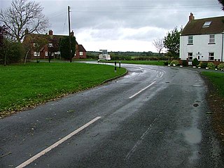
Walworth is a central small village with outlying farmsteads, which together constitute a scattered village in the borough of Darlington and the ceremonial county of County Durham, England. It is a civil parish which does not have a church. The population of this civil parish at the 2011 Census was 240. It is situated 2.5 miles (4.0 km) to the north-west of Darlington. The nucleus of the central village is the 16th-century Walworth Castle, which is now a hotel. On the north side of the village, around North Farm, are earthworks signifying a lost settlement, grouped around a barn which was once a chapel.

Walworth Gate Human settlement in England

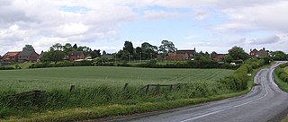
Walworth Gate is a hamlet and crossroads village in the borough of Darlington, in the civil parish of Walworth and the ceremonial county of County Durham, England. It is situated 2 miles (3.2 km) north−west of the edge of Darlington and 0.6 miles (0.97 km) north of Walworth. The settlement is locally notable for New Moor Farm, which is known to Darlington people as a producer of ice cream. The Saxon origin of the name, "Walworth Gate", refers to Welsh−speaking Britons who once lived there.

Healing, Lincolnshire Human settlement in England

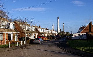
Healing is a village and civil parish in North East Lincolnshire, England. It is situated between Stallingborough and Great Coates, and 3 miles (5 km) west from Grimsby.

North Killingholme Human settlement in England

North Killingholme is a small village and civil parish in North Lincolnshire, England.
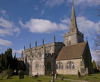
Docking, Norfolk Human settlement in England

Docking is a village and ancient civil parish in the north-west of the English county of Norfolk. It is near the North Norfolk Coast Site of Special Scientific Interest.

South Croxton Human settlement in England

South Croxton is a village and civil parish in the Charnwood district of Leicestershire, England. It had a population of 261 in the 2011 census. Nearby villages include Beeby, Barsby and Twyford.

Bigby, Lincolnshire Village and civil parish in the West Lindsey district of Lincolnshire, England

Bigby is a village and civil parish in the West Lindsey district of Lincolnshire, England.

Orby Village and civil parish in the East Lindsey district of Lincolnshire, England

Orby is a village and civil parish in the East Lindsey district of Lincolnshire, England. It is situated approximately 9 miles (14 km) east from the town of Spilsby, and 5 miles (8 km) west from the seaside resort of Skegness. The civil parish includes the hamlet of Habertoft, 1.5 miles (2.4 km) to the north-west. Orby lies within the Lincolnshire coast marshes.

Minshull Vernon Human settlement in England

Minshull Vernon is a hamlet and civil parish in the unitary authority of Cheshire East and the ceremonial county of Cheshire, England. The hamlet lies 3 miles (5 km) to the north west of Crewe, south east of Winsford and south west of Middlewich. The parish also includes the small settlements of Bradfield Green, Eardswick, Hoolgrave, Minshull Hill, Walley's Green and Weaver Bank. The total population of the civil parish is somewhat over 200, measured at 391 in the Census 2011. Nearby villages include Church Minshull, Warmingham and Wimboldsley.

Cliffe, Selby Village and civil parish in North Yorkshire, England

Cliffe is a small village and civil parish in the Selby District of North Yorkshire, England. It was historically part of the East Riding of Yorkshire until 1974.

Walworth Castle

Walworth Castle is an 11th Century castle, situated at Walworth, near Darlington, County Durham, England. It is a Grade 1 listed building. It was completed around 1600, probably by Thomas Holt for Thomas Jenison. It stands on the site of a former manor house or castle built in the 12th century by the Hansard family. The estate passed through the hands of the Ayscoughs and Aylmers besides the Hansards and Jenisons, and became a prisoner-of-war camp during World War II and then a girls' boarding school after the war. It has been a hotel since 1981.

Legsby Human settlement in England

Legsby is a small village and civil parish in the West Lindsey district of Lincolnshire, England. The population of the civil parish at the 2011 census was 193. It is situated approximately 13 miles (20 km) north-east from the city and county town of Lincoln and 3 miles (5 km) south-east from the town of Market Rasen.

Ulnaby Human settlement in England

Ulnaby is an abandoned village and scheduled ancient monument in the grounds of Ulnaby Hall Farm, near High Coniscliffe, County Durham, England. The toft village was occupied from the late-13th to the 16th century and temporary buildings were erected in the 19th century. Ulnaby Hall farm appears to have been built in the late-16th century, supplanting a high status medieval manorial enclosure associated with the original village. It is thought that the village shrank because of the change from labour-intensive arable farming to pasture, before being abandoned and the site was subsumed into the farm as pasture.

References

  1. 1 2 3 4 "Keys to the past". Archdeacon Newton; deserted Medieval village. (Archdeacon Newton). DCC. 2010. Archived from the original on 16 June 2011. Retrieved 9 April 2010.
  2. "The motorway archive". Region: North East A1(M) & A66(M). The Darlington By-Pass motorway (J56 to J59). Motorway Archive Trust. Retrieved 9 April 2010.[ permanent dead link ]
  3. "Darlington Borough Council" (PDF). Election of a parish councillor: parish of Archdeacon Newton rural ward. DBC. 3 May 2007. Archived from the original (PDF) on 16 July 2011. Retrieved 9 April 2010.
  4. 1 2 3 "The Northern Echo". John North: a happy marriage of land and lord. Newsquest Media Group. 10 October 2002. Retrieved 9 April 2010.
  5. 1 2 3 4 5 "Keys to the past". Archdeacon Newton; moated site (Archdeacon Newton). Durham County Council. 2010. Archived from the original on 16 June 2011. Retrieved 9 April 2010.
  6. 1856–1865 map, on Keys to the Past site Archived 9 July 2012 at the Wayback Machine
  7. 1 2 3 4 "Keys to the past". Local History: Archdeacon Newton (County Durham). DCC. 2010. Archived from the original on 16 June 2011. Retrieved 9 April 2010.
  8. 1 2 3 4 5 6 7 8 "Pastscape". Archdeacon Newton. English Heritage. 2010. Archived from the original on 24 December 2012. Retrieved 9 April 2010.
  9. 1 2 "UK Genealogy archives". Archdeacon Newton. 2010. Retrieved 9 April 2010.
  10. Joiner, Paul R. (7 January 2008). "Genuki". Darlington. Retrieved 9 April 2010.
  11. "Keys to the past". Archdeacon Newton, Darlington.; Archaeological Watching Brief. (Archdeacon Newton). DCC. 2010. Archived from the original on 16 June 2011. Retrieved 9 April 2010.
  12. Ramblers' Association (August 1999). "Walks around the Borough of Darlington" (PDF). No.6: Archdeacon Newton and Walworth. DBC. Archived from the original (PDF) on 5 October 2011. Retrieved 9 April 2010.
  13. "Keys to the past". Medieval Building, Archdeacon Newton, Darlington; Archaeological Report. (Archdeacon Newton). DCC. 2010. Archived from the original on 16 June 2011. Retrieved 9 April 2010.
  14. "Keys to the past". Barn 100 metres east of hall farmhouse; Listed building (Archdeacon Newton). DCC. 2010. Archived from the original on 16 June 2011. Retrieved 9 April 2010.
  15. "Keys to the past". Archdeacon Newton; Enclosure (Archdeacon Newton). DCC. 2010. Archived from the original on 16 June 2011. Retrieved 9 April 2010.