
Mitchell Highway is an outback state highway located in the central and south western regions of Queensland and the northern and central western regions of New South Wales in Australia. The southern part of Mitchell Highway forms part of the National Highway A32 corridor, which stretches from Sydney to Adelaide via Dubbo and Broken Hill. Mitchell Highway also forms part of the shortest route between Sydney and Darwin, via Bourke and Mount Isa, making it an important road link for the transport of passengers and freight for regional New South Wales and Queensland. The highway is a part of route Alternative A2 between Augathella and Charleville, route A71 and B71 between Charleville and Nyngan, and part of route A32 between Nyngan and Bathurst.

Barrier Highway is a highway in South Australia and New South Wales, and is designated part of route A32. The name of the highway is derived from the Barrier Ranges, an area of moderately high ground in the far west of New South Wales, through which the highway traverses.

Nyngan is a town in the centre of New South Wales, Australia, in the Bogan Shire local government area within the Orana Region of central New South Wales. At the 2016 census, Nyngan had a population of 1,988 people. Nyngan is situated on the Bogan River between Narromine and Bourke, on the junction of the Mitchell Highway and Barrier Highway, 656 km (408 mi) south of Charleville and 576 km (358 mi) north-west of Sydney by road. The Barrier Highway starts at Nyngan, and runs west to Cobar and on through Wilcannia and Broken Hill into South Australia.
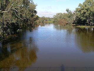
Bogan River, a perennial river that is part of the Macquarie–Barwon catchment within the Murray–Darling basin, is located in the central west and Orana regions of New South Wales, Australia.
The Division of Darling was an Australian electoral division in the state of New South Wales. The division was proclaimed in 1900, and was one of the original 65 divisions to be contested at the first federal election. From 1901 until 1922 it was based on Bourke, Cobar, Nyngan, Coonamble and Gilgandra. From 1906, it also included Dubbo. The 1922 redistribution increased the number of voters in some rural electorates and as a result the division of Barrier was abolished with most of its population, including the large mining town of Broken Hill, Wentworth and Balranald, was absorbed by Darling along with Hay from Riverina. Dubbo was transferred to Gwydir in 1922 but returned to Darling in 1934. In 1948, Dubbo, Gilgandra and Coonamble were transferred to the new division of Lawson and Hay and Balranald were transferred to Riverina. In 1955 Coonamble returned to Darling. In 1977 it was abolished with Broken Hill and Wentworth going to Riverina and Bourke, Cobar, Nyngan and Coonamble going to Gwydir.

Bogan Shire is a local government area in the Orana region of New South Wales, Australia. The Shire is located adjacent to the Mitchell and Barrier highways and its only significant town is Nyngan.
The Main Western Railway is a major railway in New South Wales, Australia. It runs through the Blue Mountains, Central West, North West Slopes and the Far West regions. It is 825 kilometres (513 mi) with 484 kilometres (301 mi) operational & 341 kilometres (212 mi) under construction & repairs.

The Castlereagh League is a rugby league competition in western New South Wales, Australia, run under the auspices of the Country Rugby League. For all intents and purposes the competition is effectively the Group 14 Rugby League senior competition.

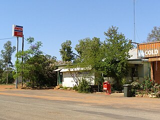
Byrock is a small village in north western New South Wales, Australia in Bourke Shire. In 2016, Byrock had a population of 50 people.
Mudgee Airport is an airport located 3 nautical miles north northeast of Mudgee, New South Wales, Australia. The airport is frequently used for technical training.
Cobar was an electoral district of the Legislative Assembly in the Australian state of New South Wales which was named after the town of Cobar. It was first created in 1894 and abolished in 1920. Cobar was recreated in 1930 and abolished in 1968.
The Bogan was an electoral district of the Legislative Assembly in the Australian state of New South Wales, created in 1859 and named after the Bogan River. It elected two members between 1880 and 1889 and three members between 1889 and 1894. It was abolished in 1894 and partly replaced by Cobar, Dubbo and Coonamble.
The Cobar railway line is a railway line in New South Wales, Australia. It branches west towards Cobar from the Main West Line at Nyngan. The Main West once continued northwest to Bourke but is now closed beyond Nyngan. However, copper concentrates from mines near Hermidale and Cobar are still railed on this line to ports on the New South Wales coast.

ABC Western Plains is an ABC Local Radio station based in Dubbo, New South Wales. The broadcast region stretches from Wellington north to Goodooga and west from Coonabarabran to Wilcannia. The station covers the top half of the Far West region and part of the Orana region of New South Wales. This includes Dubbo City and the towns of Bourke, Cobar, Nyngan, Walgett, Mudgee, Lightning Ridge, Gilgandra, Coonamble and Warren
Coolabah is a small village in western New South Wales, Australia, 76 km north of Nyngan and 656 km north-west of Sydney. It lies on either side of the Mitchell Highway, with the area to the east of the highway in Brewarrina Shire and the westerly area in Bogan Shire.

The Nyngan Solar Plant or Farm is one of the largest operating solar plants in Australia. At the time of construction, it was the largest solar plant in the southern hemisphere. It is located 10 km west of Nyngan in western New South Wales. It was built and is operated by AGL Energy.

Nyngan Court House is a heritage-listed courthouse located at 77-79 Cobar Street, Nyngan, in the Bogan Shire, New South Wales, Australia. It was designed by Walter Liberty Vernon and built in 1902. The property is owned by NSW Department of Justice. It was added to the New South Wales State Heritage Register on 2 April 1999.
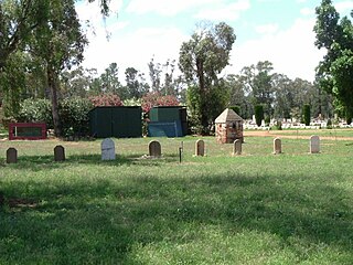
The Chinese Graves and Burner at Nyngan Cemetery is a heritage-listed burial site located at Cemetery Road, Nyngan, in the Bogan Shire, New South Wales, Australia. They were created from 1913 to 1924. The property is owned by NSW Land Registry Services, a privatised agency of the New South Wales Government. The site was added to the New South Wales State Heritage Register on 13 March 2009.

Bourke railway station is a heritage-listed disused railway station in Bourke, in the Far West region of New South Wales. The station opened in 1885 as the terminus of the Main Western line. Passenger trains to Bourke ceased in 1975 when the rail service beyond Dubbo was replaced by road coaches. NSW TrainLink continues to serve the station by coach. The property belongs to the Country Regional Network (CRN), which is owned by Transport for NSW and operated by John Holland Rail.
