
William Charles Wentworth was an Australian explorer, journalist, politician and author, and one of the leading figures of early colonial New South Wales. He was the first native-born Australian to achieve a reputation overseas, and a leading advocate for self-government for the Australian colonies.

The Darling River is the third longest river in Australia, measuring 1,472 kilometres (915 mi) from its source in northern New South Wales to its confluence with the Murray River at Wentworth, New South Wales. Including its longest contiguous tributaries it is 2,844 km (1,767 mi) long, making it the longest river system in Australia.
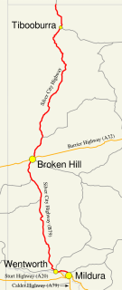
The Silver City Highway is a 683-kilometre-long (424 mi) highway that links Buronga, New South Wales to the Queensland border via Wentworth, Broken Hill, and Tibooburra, in the arid Far West region of New South Wales. A short branch also connects to the Calder Highway on the Victorian border at Curlwaa. This branch is also signed as the Calder Highway, despite legally being part of the Silver City Highway. Parts of the highway north of Broken Hill are unsealed. The namesake of the highway is derived from the moniker for Broken Hill–the "Silver City", which the highway travels through.

Wentworth is a small border town in the far south west of the state of New South Wales, Australia. It lies at the confluence of Australia's two most important rivers, the Darling and the Murray, the latter forming the border with the state of Victoria to the south. The border with the state of South Australia lies approximately 100 kilometres (62 mi) to the west. The town of Wentworth is in the local government area of the same name.
The Sunraysia is an ill–defined district, sometimes incorrectly referred to as an economic region, located in northwestern Victoria and southwestern New South Wales in Australia. The region is renowned for its sunshine, intensive horticulture including grapes and oranges, and grain farms. Its main centre is Mildura, Victoria.

Abercrombie River, a perennial river that is part of the Murray–Darling basin, is located in the central west of New South Wales, Australia.

Wentworth Park is a park near the suburbs of Glebe and Ultimo in Sydney, New South Wales, Australia.
The Southern Cross Drive is a 4.8 km (3 mi) dual carriage untolled motorway in Sydney, New South Wales, Australia. Part of the M1 and Sydney Orbital Network, the road, a freeway that opened in 1969, links the Eastern Distributor and South Dowling Street at Kensington in the north to General Holmes Drive at Sydney Airport in the south.

Wentworth Shire is a local government area in the far south-west Riverina region of New South Wales, Australia. This Shire is located adjacent to the Murray and Darling Rivers. The Shire's major roads are the Sturt and the Silver City Highways. The Shire includes the towns of Wentworth, Buronga, Gol Gol, Dareton and Pooncarie.

Broken Hill Airport is an airport located 2.5 nautical miles southeast of Broken Hill, New South Wales, Australia.

Cooma–Snowy Mountains Airport is an airport located 9 nautical miles southwest Cooma, New South Wales, Australia. The airport serves the town of Cooma and the resorts of the Snowy Mountains and Australian Alps. The airport experiences increased traffic during the winter months.

General Holmes Drive is a 5-kilometre (3.1 mi) major divided road located in Sydney, New South Wales, Australia. The road forms part of the M1, the A1, the Sydney Orbital Network, and the Australian Highway 1 network. Initially built in 1919 as a two-lane road and duplicated in 1951, the road partially circumnavigates Sydney Airport with its north-eastern terminus in Mascot, heading west and then south and then south-west, with its south-western terminus with The Grand Parade in Brighton-Le-Sands.
Wentworth was an electoral district for the Legislative Assembly in the far south west of the Australian state of New South Wales and named after and including the town of Wentworth. It established in 1880 and partly replacing Lachlan. From 1885 until 1889 it elected two members. The population in Wentworth had grown significantly since the 1880 redistribution, especially as a result of the growth of mining at Broken Hill, with the electoral roll growing from 1,901 in 1880 to 5,617 in 1887. Under the formula for seats, Wentworth was due to return 3 members, however because of the large area covered by the district, in 1889 it was split into 3, Wentworth, Sturt and Wilcannia. Wentworth retained the eponymous town, along with the towns of Menindie and Pooncaira. Sturt contained the mining boom towns of Broken Hill, Silverton and Milparinka while Wilcannia was the only town in that district.
Blue Mountains Grammar School, abbreviated as BMGS, is a dual-campus independent Anglican comprehensive co-educational early learning, primary and secondary day school, located in the Blue Mountains suburbs of Wentworth Falls and Valley Heights, New South Wales, Australia. Established in 1918, there are approximately 600 students currently enrolled over both campuses.

Wentworth Falls is a three-tiered waterfall fed by the Jamison Creek, near the town of Wentworth Falls in the Blue Mountains region of New South Wales, Australia. The falls are accessible via the National Pass Walking Trail and the Overcliff/Undercliff Walk. The total height of the waterfall is 187 metres (614 ft).

The Kings Tableland is a plateau, located in the Blue Mountains in Wollondilly Shire, New South Wales, Australia. The ridge is an eroded remnant of a sandstone layer that is approximately 1,000 metres (3,300 ft) AMSL, situated immediately south of Wentworth Falls. The Tableland is the major southerly spur of the main spine of the Blue Mountains Range and forms the beginning of the Southern Escarpment, an unbroken series of tall sandstone cliffs which fringes the Jamison, Megalong, Kanimbla and Hartley Valleys.
The Erskine Creek, a perennial stream of the Hawkesbury-Nepean catchment, is located in the Blue Mountains region of New South Wales, Australia.

The Bedford Creek, a perennial stream of the Hawkesbury-Nepean catchment, is located in the Blue Mountains region of New South Wales, Australia.

The Bennelong Bridge is a 330-metre-long (1,080 ft) vehicular bridge across Homebush Bay between the Sydney suburbs of Rhodes and Wentworth Point. It opened on 22 May 2016.
Wentworth, an electoral district of the Legislative Assembly in the Australian state of New South Wales, was created in 1859 and abolished in 1904.
