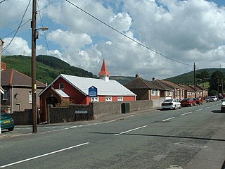
Amenities in Penperlleni

The Goytre Arms in Penperlleni

Goytre Fawr Primary School

Goytre Village Hall & Social Club

Penperlleni Post Office
Penperlleni is a hamlet within community and electoral ward of Goetre Fawr in Monmouthshire, Wales.
Penperlleni is a hamlet within community and electoral ward of Goetre Fawr in Monmouthshire, Wales.
The name of Penperlleni derives from two Welsh words, Pen refers to the summit or top of a hill, the second element perlleni, has been interpreted as meaning a "round mass" and an "area of round hills", although the current Welsh word for orchard (perllan) may apply. [1]
Penperlleni was previously known as Pelleny (1256), Pethllenny (1330), Pelleny (1349) and Pellenig (1593). [1] Penperlleni has a number of amenities, including a primary school, Goytre Fawr Primary School and a church, Capel Ed, a public house, the Goytre Arms and a village hall and post office.
Penperlleni lies on the Newport–Shrewsbury Trunk Road (A4042 road).
Llanvapley is a village in the community of Gobion Fawr, in Monmouthshire, south east Wales, United Kingdom. Llan has replaced the (earlier) Eglwys (1254).

Llantwit Major is a town and community in Wales on the Bristol Channel coast. It is one of four towns in the Vale of Glamorgan, with the third largest population after Barry and Penarth, and ahead of Cowbridge. It is 4+1⁄2 miles (7.2 km) from Cowbridge, 9 miles (14 km) from Bridgend, 10 miles (16 km) from Barry, and 15 miles (24 km) from Cardiff. It had a population of 9,486 in 2011.

Llanfoist is both a village near Abergavenny, in Monmouthshire, Wales, and the community of Llanfoist Fawr. Llanfoist derives from Ffwyst, an early Christian Welsh saint, although the anglicised version of the church patron is Saint Faith. The population was 1,228 in 2011.

The Black Mountains are a group of hills spread across parts of Powys and Monmouthshire in southeast Wales, and extending across the England–Wales border into Herefordshire. They are the easternmost of the four ranges of hills that comprise the Brecon Beacons National Park, and are frequently confused with the westernmost, which is known as the Black Mountain. The Black Mountains may be roughly defined as those hills contained within a triangle defined by the towns of Abergavenny in the southeast, Hay-on-Wye in the north and the village of Llangors in the west. Other gateway towns to the Black Mountains include Talgarth and Crickhowell. The range of hills is well known to walkers and ramblers for the ease of access and views from the many ridge trails, such as that on the Black Hill (Herefordshire) at the eastern edge of the massif. The range includes the highest public road in Wales at Gospel Pass, and the highest point in southern England at Black Mountain.
Goytre Association Football Club is a football club is based in the village of Penperlleni, Monmouthshire in South Wales. The team play in the Ardal Leagues South East, tier 3 of the Welsh football pyramid.

Rhigos is a small village on the saddle of higher ground between the Vale of Neath and the Cynon Valley. It was part of the old Neath Rural district Council under Glamorgan until 1974. The village then came under the jurisdiction of The Cynon Valley Borough which subsequently became Rhondda Cynon Taf, South Wales in 1996. It lies just off the old Aberdare road that was the main link between Aberdare and Glynneath, before the A465 road was extended in the 1960s. The hamlets of Cefn Rhigos and Cwm-Hwnt lie to the west of the main village.
Little Mill is a village in Monmouthshire, south east Wales, United Kingdom, in the community and ward of Goetre Fawr. It has a population of about 600.

The Black Mountain is a mountain range in South, Mid and West Wales, straddling the county boundary between Carmarthenshire and Powys and forming the westernmost range of the Brecon Beacons National Park. Its highest point is Fan Brycheiniog at 802 metres or 2,631 ft. The Black Mountain also forms a part of the Fforest Fawr Geopark.
The suburban district of Sketty is about 2 miles (3.2 km) west of the Swansea city centre on Gower Road. It falls within the Sketty council ward of Swansea. It is also a community.
Goytre is a village near the town of Port Talbot, Wales.

The Ewenny River is a river in South Wales. For most of its 10 miles (16 km) length, it forms the border between the Vale of Glamorgan and Bridgend. It is a major tributary of the River Ogmore, which it joins near its estuary.

Goytre is a village in the community of Goetre Fawr in Monmouthshire, south east Wales, United Kingdom.
The Beacons Way is a waymarked long distance footpath in the Brecon Beacons National Park, Wales. It is a linear route which runs for 99 miles (159 km) east to west through the National Park, and passes many of the most important landmarks and mountain peaks in the mountain range. It also includes a few of the towns in the park as well as popular attractions such as Carreg Cennen Castle near Llandeilo at the western end of the path.

The Grwyne Fawr is a river in the Brecon Beacons National Park in south Wales. A section of it forms the administrative border between Powys and Monmouthshire and also of the historic counties of Brecon and Monmouth. The river and its major tributary the Grwyne Fechan flow into the River Usk at Glangrwyney.

Y Garn Goch is a hill in the Brecon Beacons National Park in the east of Carmarthenshire, Wales. The name means the 'red cairn'. It lies near the village of Bethlehem, three miles southwest of Llangadog and four miles east of Llandeilo on the southern side of the broad Towy Valley. It is also commonly known as either Garn Goch or Carn Goch. Current owners and land managers are the Brecon Beacons National Park Authority.
Cadair Fawr is a hill in the northern corner of the county borough of Rhondda Cynon Taf, Wales. It lies within the Brecon Beacons National Park and Fforest Fawr Geopark. The 485m high summit at OS grid ref SN 978123 is marked by a trig point. Cadair Fawr is the highest point of a broad ridge known as Cefn Cadlan which forms the northern edge of Cwm Cadlan, a valley which itself runs east-northeastwards from the village of Penderyn. The name Cadair Fawr signifies the 'big chair' whilst Cefn Cadlan signifies the 'ridge of the battlefield'.
Llanfechell is a village in Anglesey, Wales. It is the largest of several small villages and dispersed settlements that make up Mechell Community Council area. It is 11 miles (18 km) east of Holyhead, and 5.6 miles (9 km) west of Amlwch, in the north of the island.

Rhosybol is a village and community in Anglesey, Wales. The community population at the 2011 census was 1,078. Located 2.5 miles (4.0 km) south of the town of Amlwch, the village is close to both Llyn Alaw, the largest body of water on the island, and Parys Mountain, the site of the historic copper mines which lies just to the north. It is to the mines that the village owes its existence as it was one of several built to house the miners. During the 1960s noted painter Kyffin Williams produced an oil painting of the village.

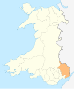
Goetre Fawr is a community and electoral ward in Monmouthshire, Wales, a few miles south of the town of Abergavenny.
Coordinates: 51°44′11″N2°58′57″W / 51.73639°N 2.98250°W