Wolvesnewton (Welsh : Llanwynell) [1] is a small village in Monmouthshire, Wales.
Wolvesnewton (Welsh : Llanwynell) [1] is a small village in Monmouthshire, Wales.
Wolvesnewton, sometimes historically Wolves Newton, is in the community of Devauden, in Monmouthshire, south east Wales, [2] 6 miles (9.7 km) north west of Chepstow, and between the villages of Devauden and Llangwm. [2] It lies in the traditional Upper Division of the Hundred of Raglan. [3]
The village and civil parish took their English name from the family of Lupus (Wolf) or Lovel, who were lords of the manor in the 13th and 14th century. [4]
The official Welsh name, Llanwynell, also found on many maps, is derived from the name of the reputed Saint Gwynell, noted by Lewys Dynn as "Syr Vwniel L. of(f) Wolffs Newton(,) Knight. He accepted the Christian Faith año 188, and erected a church at his own expense." In a list of Welsh parishes circa 1556, and in other later lists, Gwynell is given the parish of Llanwynell or Llanwnell. [5]
In the 13th and 14th centuries, the area was held as a manor by the Lupus / Wolff / Lovel family, with their manor house at Cwrt-y-gaer. According to family tradition, they originated in Thuringia and came to the area with the Romans. [4] The village is located to the north of Wentwood, which in Norman times covered a larger area than today. [6] Forest clearances under the Normans led to the establishment of several other "new" villages in the area around the same time, such as Shirenewton about 4 miles (6.4 km) to the south. [7]
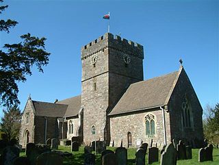
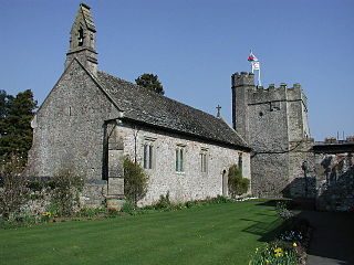
The parish church is dedicated to St Thomas à Becket who had been killed in 1170 and was canonised three years later. The church largely dates from the 13th century but was substantially restored in 1855–57. It has a 16th-century "saddle-back" roof, and three bells. The north side of the churchyard is locally called the "devil's side" and has no graves. [8] The war memorial in the churchyard incorporates part of a large mediaeval stone cross. [9]
The Iron Age hill fort at Gaer Fawr (meaning in Welsh, "great fort"), about 1 mile (1.6 km) south west of Wolvesnewton, is the origin of a second Welsh name for the village, and is one of the largest hill forts in Monmouthshire. That second Welsh name, "Trenewydd Dan-y-Gaer, means "new town under the fort". [10] [11]
From the 1970s to 1996 the village was the home of the Model Farm Folk Museum and Craft Centre. This was arranged around an actual model farm built for the Duke of Beaufort, with a farmhouse, roundhouse and mill. It was built in 1780, [8] but not fully mapped until after 1841. It was sold by the Beauforts to the then owners of a major local house, Tredean, in 1900, and later sold on to the owner of another major local property, Itton Court. [12] After the museum closure, it was converted into housing. [8]

Itton, is a small village in Monmouthshire, south-east Wales, in the community of Devauden about 3 miles (4.8 km) north-west of Chepstow. The village covers about a 2-mile (3.2 km) radius, with about 70 properties across a rural area. The parish also includes the hamlet of Howick.

Caldicot was an ancient hundred of Monmouthshire, Wales.

St Brides Netherwent is a parish and largely deserted village in Monmouthshire, south-east Wales. It is centred 2 miles north of Magor, and 3 miles west of Caerwent. The A48 Newport to Chepstow road passes close by to the north.
Shirenewton is a village and community in Monmouthshire, south east Wales. It is located 3 miles due west of Chepstow, 5 miles (8 km) by road. The village stands around 500 feet above sea level, and has extensive views of the Severn Estuary and Bristol Channel. The population of the village and the conjoined village of Mynydd-bach was 657 in 2011.

Llanvair Discoed is a small village in Monmouthshire, south-east Wales, 6 miles west of Chepstow and 10 miles east of Newport.

Raglan (; is a village and community in Monmouthshire, south-east Wales, United Kingdom. It is located some 9 miles south-west of Monmouth, midway between Monmouth and Abergavenny on the A40 road very near to the junction with the A449 road. It is the location of Raglan Castle, built for William ap Thomas and now maintained by Cadw. The community includes the villages of Llandenny and Pen-y-clawdd. Raglan itself has a population of 1,183.

Llantilio Crossenny is a small village and much larger former community, now in the community of Whitecastle, in Monmouthshire, south east Wales, in the United Kingdom. It is situated between the two towns of Abergavenny and Monmouth on the B4233 road. The community included Penrhos, and Llanvihangel-Ystern-Llewern.
Llanvihangel-Ystern-Llewern is a village in the community of Whitecastle, in Monmouthshire, south east Wales. It is located between Abergavenny and Monmouth and north of Raglan. The River Trothy passes close by.
Mitchel Troy is a village and community in Monmouthshire, south east Wales, in the United Kingdom. It is located 3 miles south west of the county town of Monmouth, just off the A40 road leading towards Raglan. Settlements within the community include Tregare, Dingestow, Cwmcarvan and Wonastow.

Earlswood is a rural area of scattered settlement in Monmouthshire, south east Wales, United Kingdom. It is located five miles northwest of Chepstow, within the parish of Shirenewton and immediately east of the forested area of Wentwood.

Trelleck Grange is a small hamlet in a rural area of Monmouthshire, south east Wales, United Kingdom, about seven miles south of Monmouth.

Kilgwrrwg is a rural parish in Monmouthshire, south east Wales, United Kingdom. It is located 7 miles (11 km) north west of Chepstow and 7 miles (11 km) south east of Usk in a network of country lanes running through the rolling hills below the Trellech ridge.

Newchurch is an extensive rural parish and small hamlet in Monmouthshire, south east Wales. It is located 6 miles south east of Usk and 6 miles north west of Chepstow, between the B4235 and B4293 roads.
St Pierre is a former parish and hamlet in Monmouthshire, south east Wales, 3 miles (4.8 km) south west of Chepstow and adjacent to the Severn Estuary. It is now the site of a large golf and country club, the Marriott St Pierre Hotel & Country Club, which was previously a large manor house and deer park belonging to the Lewis family.

Penterry is a small rural parish of 479 acres (1.94 km2) in Monmouthshire, Wales. It is located between the villages of St. Arvans and Tintern, about 4 miles (6.4 km) north of Chepstow, within the Wye Valley Area of Outstanding Natural Beauty and about 2 miles (3.2 km) from the border with England. It now contains an isolated parish church adjoining the site of a deserted village, and a few farms.
Llanfihangel Tor-y-Mynydd is a small rural village in the community of Devauden, Monmouthshire, Wales. It is located within the Vale of Usk, about 9 miles south west of Monmouth and 6 miles east of the town of Usk, between the villages of Devauden and Llansoy.

St Cadoc's Church, Raglan, Monmouthshire, Wales, is the parish church of the village of Raglan, situated at a cross-roads in the centre of the village. Built originally by the Clare and Bluet families in the thirteenth and fourteenth centuries, it was rebuilt and expanded by the Herbert's of Raglan Castle in the fifteenth century. In the nineteenth century the church was subject to a major restoration by Thomas Henry Wyatt.

St Cenedlon's is a parish church in the village of Rockfield, Monmouthshire, Wales. The dedication to St Cenedlon is unusual and the history of the saint is obscure. Some sources suggest that she was a daughter of Brychan king of Brycheiniog while others identify her as the wife of King Arthfael ab Ithel, king of Glywysing. The existing church dates from the Middle Ages but only the tower remains from that period. After the English Reformation, the surrounding area of north Monmouthshire became a refuge for Catholics and Matthew Pritchard (1669-1750), Roman Catholic bishop and Vicar Apostolic of the Western District is buried at the church. By the mid-19th century the church was in ruins and a complete reconstruction was undertaken by the ecclesiastical architects John Pollard Seddon and John Prichard in around 1860. St Cenedlon's is an active parish church in the Diocese of Monmouth. It is designated by Cadw as a Grade II listed building.

Llansantffraed is the smallest parish in Monmouthshire, Wales, located four miles to the west of Raglan, north of the A40 between Raglan and Abergavenny. There is no community, only the Llansantffraed Court estate and the church.

Perth-hir House, Rockfield, Monmouthshire, Wales, was a major residence of the Herbert family. It stood at a bend of the River Monnow, to the north-west of the village. At its height in the 16th century, the mansion, entered by two drawbridges over a moat, comprised a great hall and a number of secondary structures. Subsequently in the ownership of the Powells, and then the Lorimers, the house became a centre of Catholic recusancy following the English Reformation. By the 19th century, the house had declined to the status of a farmhouse and it was largely demolished in around 1830. Its ruins, and the site which contains considerable remnants of a Tudor garden, are a scheduled monument.
{{cite book}}: CS1 maint: location missing publisher (link)51°41′36″N2°47′29″W / 51.69338°N 2.79133°W