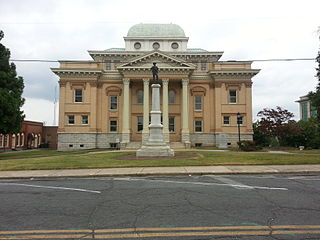
Randolph County is a county located in the U.S. state of North Carolina. As of the 2020 census, the population was 144,171. Its county seat is Asheboro.

Block Island Southeast Light is a lighthouse located on Mohegan Bluffs at the southeastern corner of Block Island, Rhode Island. It was designated a U.S. National Historic Landmark in 1997 as one of the most architecturally sophisticated lighthouses built in the United States in the 19th century.

Pisgah National Forest is a National Forest in the Appalachian Mountains of western North Carolina. It is administered by the United States Forest Service, part of the United States Department of Agriculture. The Pisgah National Forest is completely contained within the state of North Carolina. The forest is managed together with the other three North Carolina National Forests from common headquarters in Asheville, North Carolina. There are local ranger district offices located in Pisgah Forest, Mars Hill, and Nebo.

Old Blenheim Bridge was a wooden covered bridge that spanned Schoharie Creek in North Blenheim, New York, United States. With an open span of 210 feet (64 m), it had the second longest span of any surviving single-span covered bridge in the world. The 1862 Bridgeport Covered Bridge in Nevada County, California, currently undergoing repairs due to 1986 flooding is longer overall at 233 feet (71 m) but is argued to have a 208 feet (63 m) clear span. The bridge, opened in 1855, was also one of the oldest of its type in the United States. It was destroyed by flooding resulting from Tropical Storm Irene in 2011. Rebuilding of the bridge commenced in 2017 and was completed in 2018.

The Joel Lane House, also known as Wakefield, was built in 1769 and is now a restored historic home and museum in Raleigh, North Carolina. It is the oldest dwelling in Wake County and contains collections of 18th century artifacts and period furnishings. The museum grounds include a detached middle-class home built circa 1790, a formal city garden, and a period herb garden. The house is named after Joel Lane, the "Father of Raleigh" and "Father of Wake County."

Maybury Hill is a historic house at 346 Snowden Lane, in Princeton, Mercer County, New Jersey, United States. Built about 1725, it was the birthplace and boyhood home of Joseph Hewes (1730-1799), a signer of the United States Declaration of Independence. The house, an architecturally excellent example of Georgian domestic architecture, was designated a National Historic Landmark in 1971 for its association with Hewes. It is a private residence not open to the public.

The Lynchburg Covered Bridge is a historic wooden covered bridge that spans the east fork of the Little Miami River in Lynchburg, Ohio. It, also, has the distinction, following a recent repair and restoration project, of being the only such covered bridge in North America to have been converted to a pseudo-suspension infrastructure. The bridge was built in 1870 as a Long truss.

The Hillsgrove Covered Bridge is a Burr arch truss covered bridge over Loyalsock Creek in Hillsgrove Township, Sullivan County, in the U.S. state of Pennsylvania. It was built c. 1850 and is 186 feet (56.7 m) long. In 1973, it became the first covered bridge in the county to be placed on the National Register of Historic Places (NRHP). The bridge is named for the township and nearby unincorporated village of Hillsgrove, and is also known as Rinkers Covered Bridge for an adjoining farm.

The Belknap Bridge crosses the McKenzie River near the unincorporated community of Rainbow in Lane County, Oregon, United States. It is approximately three miles west of the town of McKenzie Bridge which is named after the bridge. It is the fourth covered bridge built on the site. The bridge is well maintained and open to traffic. The Belknap Bridge is listed on the National Register of Historic Places.

The Bunker Hill Covered Bridge is one of two covered bridges left in North Carolina,, and is possibly the last wooden bridge in the United States with Haupt truss construction. It was built in 1895 by Andrew Loretz Ramsour (1817–1906) in Claremont, North Carolina, and crosses Lyle Creek.
The Slate Covered Bridge is a wooden covered bridge which carries the Westport Village Road over the Ashuelot River in Westport, a village of Swanzey, New Hampshire. The bridge was built in 2001, as a replacement for an 1862 bridge that was destroyed by arson fire in 1993. The 1862 bridge, one of New Hampshire's small number of surviving 19th-century covered bridges, was listed on the National Register of Historic Places in 1978.

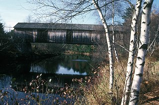
Watson Settlement Bridge was an historic covered bridge in eastern Littleton, Maine, United States. Built in 1911, it was one of the youngest of Maine's few surviving covered bridges. It formerly carried Framingham Road over the Meduxnekeag River, but was closed to traffic, the road passing over a modern bridge to its south. It was listed on the National Register of Historic Places in 1970. It was destroyed by fire on July 19, 2021.

The Contoocook Railroad Bridge is a covered bridge on the former Contoocook Valley Railroad line spanning the Contoocook River in the center of the village of Contoocook, New Hampshire, United States. It is referred to in the National Register of Historic Places as the Hopkinton Railroad Covered Bridge, for the town of Hopkinton, New Hampshire, in which the village of Contoocook is located.
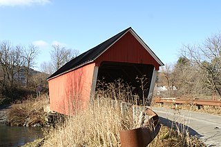
The Gifford Covered Bridge, also called the C.K. Smith Covered Bridge, is a wooden covered bridge that crosses the Second Branch of the White River in Randolph, Vermont on Hyde Road. It was listed on the National Register of Historic Places in 1974. It is one of two bridges in the state that was uncovered when first built, its trusses boxed for shelter.

The Kingsbury Covered Bridge, also called the Hyde Covered Bridge, is a wooden covered bridge that carries Kingsbury Road across the Second Branch of the White River in Randolph, Vermont. Built in 1904, it is last documented covered bridge to be built in Vermont during the historic 19th and early 20th century period. It was listed on the National Register of Historic Places in 1974.
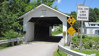
The Fuller Covered Bridge, also known as the Blackfalls Covered Bridge is a wooden covered bridge that crosses Black Falls Brook in Montgomery, Vermont on Fuller Bridge Road. It was listed on the National Register of Historic Places in 1974. The bridge is one of a concentrated regional collection built by brothers Sheldon & Savannah Jewett.

The Dingleton Hill Covered Bridge, also known as the Cornish Mills Bridge, is a historic wooden covered bridge, carrying Root Hill Road over Mill Brook in Cornish Mills, New Hampshire. Built in 1882, it is one of the state's few surviving 19th-century covered bridges. It was listed on the National Register of Historic Places in 1978. It carries one lane of traffic, with a posted weight limit.

The Porter-Parsonsfield Bridge is a covered bridge in western Maine, and one of the few 19th-century covered bridges left in the state. The bridge spans the Ossipee River just east of the modern alignment of North Road, which it formerly carried, between the towns of Porter and Parsonsfield. Built in 1876 by the towns, it is a Paddleford truss bridge which has been strengthened with laminated arches. The bridge was closed to traffic in 1960, and is now maintained by the state. It was listed on the National Register of Historic Places in 1970.
Skeen's Mill Covered Bridge was a wooden covered bridge that spanned a branch of the Little Uwharrie River in Randolph County, North Carolina. It was built between about 1885 and 1900, and measured 100 feet long. The bridge had a combination of Ithiel Town lattice truss and queenpost truss construction. It had a gable roof and board-and-batten siding. It has been demolished.

The Lincoln Covered Bridge is a historic covered bridge, just south of U.S. Route 4 in West Woodstock, Vermont. Built in 1877, it is one of the only known examples of a wooden Pratt truss bridge in the United States. It was listed on the National Register of Historic Places in 1973.


